In these PoCs, TRI-AD verified that both following methods are effective for HD map building:
- Building map information for automated driving via map data derived from the cameras of ordinary vehicles as well as satellite imagery, without the use of conventional means of collecting data such as survey vehicles
- Applying vehicle data from TRI-AD’s Automated Mapping Platform (AMP) to other companies’ platforms by converting data formats and applying correcting algorithms.
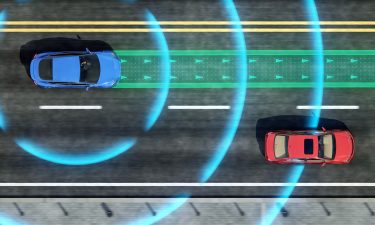
By utilising the results of these PoCs, it is expected that the delay in updating HD maps for automated driving can be shortened, areas of HD map coverage can reportedly be expanded quickly, and costs to build and maintain the HD maps can be reduced.
Maxar Technologies (
The PoC reportedly demonstrated that it is now possible to automatically extract the required map information by analysing and removing and correcting non-map image pixels such as automobiles, shadows, and occlusions due to the inclination of buildings in satellite imagery. Currently, maps with a relative accuracy of 25 centimetres1 were created within the 23 wards in
CARMERA
TRI-AD and a road intelligence platform,
The project achieved a relative accuracy of 40 centimetres1 for key navigation feature – -a major advance in camera-only detection. TRI-AD’s work with CARMERA used the same hardware-agnostic computer vision and processing technology as CARMERA’s Real-Time Events and Change Management engine, which detects, validates and delivers navigation-critical updates to CARMERA’s regenerative HD mapping system in minutes rather than months. By using consumer-grade vehicle cameras that are common around the world, TRI-AD and CARMERA are said to have showcased a scalable approach to next-generation map making.
TomTom
TRI-AD also collaborated on a PoC with
HERE
TRI-AD also collaborated with location data and technology platform, HERE Technologies (HERE) for this PoC. Correcting the positional errors in the vehicle data collected by TRI-AD, HERE was able to automatically create surface road maps using HERE’s advanced ‘Self-Healing’ technology. By using only vehicle sensor data, HERE ingested the data into its platform and automatically generated HD maps including lane level information required for automated driving.
Mandali Khalesi, Vice President of Automated Driving Strategy and Mapping at TRI-AD, said, “I’m very pleased to announce the results of the PoCs with
Reference
1. Reference values in some environments with good data accuracy in the target areas of these PoCs.
© Russell Publishing Limited, 2020. All Rights Reserved., source
