Dr.
Key Takeaways From the Altar Geological-Structural Model
- The current Altar mineral resource model, released in 2018 and created by the previous operator of the project, is based on a strictly geo-statistical model, and used little geological constraints or inputs. The new Altar geological-structural model offers for the first time a robust, consistent, and more realistic framework on which to calculate a new mineral resource estimate and to base any subsequent economic analyses.
- Altar consists of at least five large, mineralized porphyry centres aligned along a 7-kilometre-long corridor, with strong geological and geophysical indications of potentially several more, yet to be discovered centres:
• Evidence of multiple, overprinting mineralized intrusive phases within each of those porphyry centres, indicating that there were multiple mineralizing events at Altar.
• Evidence that all the porphyries at the Altar project are structurally controlled, something that previously had not been identified, and should have material impacts on future drill targets. - Altar had previously been viewed as a large, low-grade deposit. The Company has identified three distinct zones of higher-grade mineralization and modeled the structural and geological controls of these zones.
- There are two distinct styles of mineralization at Altar which are now properly constrained in the model:
• Secondary supergene (oxide) mineralization which occurs near surface and could potentially be amenable to SX-EW heap leach technology.
• Primary hypogene mineralization (sulphides) which occurs throughout the project and could be concentrated and ultimately shipped to a smelter. - Arsenic, in the previous mineral resource estimate, was unconstrained and because the estimate was based on a geo-statistical model the perception was that there was arsenic throughout the deposit. In reality, geological evidence indicates that arsenic at the Altar project is hosted by narrow, sub-vertical veinlets that occur within distinct structural zones that have now been meticulously modelled in three-dimensions:
• Constraining the arsenic to these structural zones in the new resource model should reduce the overall arsenic content of the primary (hypogene) copper mineralization.
• A significant amount of the arsenic at the Altar project occurs within the leach-cap and supergene zones and therefore may reduce the impact of arsenic on a potential copper concentrate, as the leach-cap rocks are not mineralized, and the supergene rocks could potentially be processed by SX-EW heap leach technology, which would not extract the arsenic.
Methodology
The new geological-structural model for the Altar project consists of a three-dimensional block measuring 5.2 km (north-south) by 8.0 km (east-west) and ~2.8 km vertically from surface, that was constructed in Leapfrog Geo by integrating and interpreting the following datasets:
- Detailed re-logging of ~115,000 m of historical drill core to capture a systematic and consistent dataset of lithologies, alteration-types, mineralization-types, and timing relationships
- Surface geological and structural mapping
- Detailed ground magnetic data
- High-resolution, satellite-borne hyperspectral data to identify zones of favourable alteration
- Regional and detailed structural mapping and analysis
Importance of Using a Geological Model Instead of a Geo-statistical Model
Previous mineral resource grade estimates at Altar for Cu, Au, Ag and As were based primarily on geo-statistical estimation methods with minimal geological constraint. The focus of the Company since acquisition has been to collect and interpret data to generate a comprehensive geologic model including major faults, lithology, oxidation states, high sulfidation zones, alteration zoning, etc. The upcoming mineral resource estimate will represent a proper geologic constrained geo-statistical model that provides a more realistic representation of the grade-tonnage relationships at Altar.
Assuming an acceptable geologic model for an orebody, a geologically constrained resource estimation will always be better than a simple geo-statistically estimated resource because it includes all the geologic knowledge, data and interpretation to properly constrain the mineral resource estimate.
Lithological Units
A total of 43 distinct lithological units were defined from either drill core and/or surface geological mapping. These 43 units were then simplified into 23 units based on similar textures and compositions and these were then used in the geological model and the upcoming resource update. Finally, these 23 units were further grouped into six time-stages, based on their spatial and timing relationships. The relationships between the various individual intrusive events with both alteration and mineralization is shown in Figures 1 and 2.
Structural Domains
A total of 35 discrete fault-bounded structural domains have been defined within the Altar project area (Figure 3). These fault blocks have been defined based on regional structural analysis, detailed field mapping and the sub-surface drill holes. All the Altar porphyry centres exhibit a strong structural control in terms of their emplacement, orientations of mineralization, and local post-mineralization fault offsets. The importance of these structural controls was not recognized or fully appreciated prior to Aldebaran’s current work. The implications of these structural domains are the identification within each of the porphyry centres of:
- Preferred orientations of higher-grade copper mineralization that can be more easily tested for extensions in the cases where they are currently open.
• Each of the porphyry centres has its own set of preferred orientations. - Preferred orientations of structural corridors containing narrow, subvertical quartz-enargite-pyrite veinlet zones, which will better constrain the distribution of arsenic.
• Each of the porphyry centres has its own set of preferred orientations. - Post-mineral faulting and offsets, on the order of 10s to potentially 100s of metres in some cases, that have jostled the original mineralization distribution and created opportunities for discovering new mineralization.
• Upthrown blocks may bring the mineralization closer to surface, while downthrown blocks may have hidden better mineralization below areas where there is currently only shallow drilling.
Copper Equivalent (CuEq%) Grade Shell Modeling
Using the new geological-structural model described above as a framework, grade shells at different cut-offs were modeled for copper, gold, and copper equivalent (Figures 4 and 5). The purpose of these grade shells is to better highlight the distribution and geometry of the higher-grade mineralized zones and will be used as guides for the upcoming mineral resource estimate and to also highlight areas for additional resource extension drilling.
Note: CuEq values were calculated using copper, gold and silver. Metal prices utilized for the calculations are Cu =
Secondary (Supergene) Oxide and Sulphide Copper (Cu%)
Special attention was given to modeling secondary (supergene) copper zones. Most of this style of mineralization occurs at Altar Central, however it is also observed at QDM/Radio and Altar East. Identifying significant supergene mineralization could have material economic impacts on the future development of Altar as SX-EW technology is viewed as being less capital intensive (see Figures 6 and 7).
Primary (Hypogene) Sulphide Copper Distribution
The primary (hypogene) copper zones amenable to traditional milling and flotation technology make up the bulk of the known mineralization at the
Arsenic Distribution
Historically, there was a perception that arsenic is a potential issue at Altar. Prior to Aldebaran acquiring Altar, there had been no attempt to geologically constrain and model the arsenic distribution. This, in addition to using a geo-statistical model, resulted in arsenic being artificially spread out in the 2018 resource model. A significant amount of the arsenic at the Altar project occurs within the leach-cap and supergene zones primarily above Altar Central (Figure 9). This realization could have material impacts on the project as the leach-cap rocks will not be processed as they have no mineralization, and the supergene zone could potentially be processed by SX-EW heap leach technology, which would not extract the arsenic. Geological evidence indicates that the arsenic in the primary (hypogene) mineralization is hosted by sub-vertical, centimeter-scale quartz-enargite-pyrite veinlets that occur within narrow, metre- to tens of metre-scale structural zones that have now been meticulously modelled in three-dimensions, which will better constrain the arsenic in the new resource model and reduce the overall arsenic content of the reportable primary (hypogene) copper mineralization.
Alteration Types
The principal alteration types identified and modelled at Altar are Potassic-Biotite (PB), Potassic-K-Feldspar (PK), Green Sericite ± Chlorite (GSC), Tourmaline-Quartz-Sericite (TQS), White Sericite-Pyrite (WSP), Quartz-Pyrite-Clay (QPC), Sericite-High-Sulphidation (SHS), Sericite-Base Metal Carbonate (SBM), Chlorite (CHL), Gypsum-White Anhydrite (GYA), and Levander Anhydrite (ANL). At least two potassic alteration events have been documented (PBK1 and PBK2), which supports the concept that there are multiple mineralizing porphyry intrusive events. Copper mineralization is associated with both potassic alteration events, as well as with the Green Sericite ± Chlorite (GSC) and the Sericite-High-Sulphidation (SHS) alteration events. Figures 10 and 11 show the distribution and intensity of the potassic (PK + PB) and green sericite-chlorite (GSC) alteration types, which are both intimately associated with copper-gold mineralization.
Qualified Person
The scientific and technical data contained in this news release has been reviewed and approved by Dr.
ON BEHALF OF THE ALDEBARAN BOARD
“
Chief Executive Officer and Director
For further information, please consult our website at www.aldebaranresources.com or contact:
Investor Relations Manager
Phone: +1 646 583-1404
Email: laura.brangwin@aldebaranresources.com
About
Aldebaran is a mineral exploration company that was spun out of Regulus Resources Inc. in 2018 and has the same core management team. Aldebaran acquired the Rio Grande copper-gold project located in
Neither the
Forward-Looking Statements
Certain statements regarding Aldebaran, including management's assessment of future plans and operations, may constitute forward-looking statements under applicable securities laws and necessarily involve known and unknown risks and uncertainties, most of which are beyond Aldebaran's control. Often, but not always, forward-looking statements or information can be identified using words such as "plans", "expects" or "does not expect", "is expected", "budget", "scheduled", "estimates", "forecasts", "intends", "anticipates" or "does not anticipate" or "believes" or variations of such words and phrases or statements that certain actions, events or results "may", "could", "would", "might" or "will" be taken, occur or be achieved.
Specifically, and without limitation, all statements included in this press release that address activities, events or developments that Aldebaran expects or anticipates will or may occur in the future, including the proposed exploration and development of the Altar project described herein, and management's assessment of future plans and operations and statements with respect to the completion of the anticipated exploration and development programs, may constitute forward-looking statements under applicable securities laws and necessarily involve known and unknown risks and uncertainties, most of which are beyond Aldebaran's control. These risks may cause actual financial and operating results, performance, levels of activity and achievements to differ materially from those expressed in, or implied by, such forward-looking statements. Although Aldebaran believes that the expectations represented in such forward-looking statements are reasonable, there can be no assurance that such expectations will prove to be correct. The forward-looking statements contained in this press release are made as of the date hereof and Aldebaran does not undertake any obligation to publicly update or revise any forward-looking statements or information, whether as a result of new information, future events or otherwise, unless so required by applicable securities law.
Figure 1: Altar time-space diagram showing the various porphyry centres, magmatic stages, main porphyry intrusion phases in relation to the alteration and mineralization events is available at https://www.globenewswire.com/NewsRoom/AttachmentNg/0633e6c3-d889-42ca-9870-9042698a087b
Figure 2: New geological-structural model for the Altar project area is available at https://www.globenewswire.com/NewsRoom/AttachmentNg/abd97a9b-eb38-48b1-8f80-5532b5a12ac0. (A) Full project area with google earth image and topography, (B) Full project area with google earth image and topography removed - white dashed line is the cut surface represented in (C), (C) Cut away to expose the porphyry centres at Radio, Altar Central and Altar East.
Figure 3: Numbered structural blocks and geological units is available at https://www.globenewswire.com/NewsRoom/AttachmentNg/d0806304-50cb-4659-b25a-22910486c14d. Black dots are the drill collars.
Figure 4: Copper Equivalent (CuEq%) grade shells in plan view is available at https://www.globenewswire.com/NewsRoom/AttachmentNg/736d82f9-3af5-4507-88d8-29b3cda00676.
Figure 5: Copper Equivalent (CuEq%) grade shells in section view is available at https://www.globenewswire.com/NewsRoom/AttachmentNg/220dadce-652b-40af-97f6-c74c98a36ad1.
Figure 6: Secondary (supergene) copper (Cu%) plan view map is available at https://www.globenewswire.com/NewsRoom/AttachmentNg/ef1c1008-68b2-4a6d-9325-0ac12b91d9cf.
Figure 7: Secondary (supergene) copper (Cu%) cross-section map is available at https://www.globenewswire.com/NewsRoom/AttachmentNg/04799778-c80d-436d-918c-81ad1f22faf4.
Figure 8: Distribution of sulphide minerals is available at https://www.globenewswire.com/NewsRoom/AttachmentNg/9e6143fc-a933-4543-8841-084406ec18f5.
Figure 9: Arsenic distribution relation to the 0.5% Cu (black dashed line) and 0.7% Cu (magenta dashed line) grade shells is available at https://www.globenewswire.com/NewsRoom/AttachmentNg/fd0a8061-54ca-4824-9b38-3c9c98d72358. Note that most of the high arsenic is found within the leach cap and secondary (supergene) copper zones.
Figure 10: Potassic alteration (PK+PB) in relation to the 0.5% Cu (black dashed line) and 0.7% Cu (magenta dashed line) grade shells is available at https://www.globenewswire.com/NewsRoom/AttachmentNg/40856ca5-99c7-4667-bde2-f55df530d17b.
Figure 11: Green sericite-chlorite (GSC) alteration in relation to the 0.5% Cu (black dashed line) and 0.7% Cu (magenta dashed line) grade shells is available at https://www.globenewswire.com/NewsRoom/AttachmentNg/387d3c1b-79ae-45f7-8e8d-6ff1725492f9.
![]()
Figure 1: Altar time-space diagram showing the various porphyry centres, magmatic stages, main porphyry intrusion phases in relation to the alteration and mineralization events.
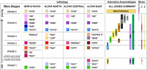
Figure 1: Altar time-space diagram showing the various porphyry centres, magmatic stages, main porphyry intrusion phases in relation to the alteration and mineralization events.
Figure 2: New geological-structural model for the Altar project area.
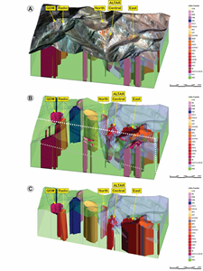
Figure 2: New geological-structural model for the Altar project area. (A) Full project area with google earth image and topography, (B) Full project area with google earth image and topography removed - white dashed line is the cut surface represented in (C), (C) Cut away to expose the porphyry centres at Radio, Altar Central and Altar East.
Figure 3: Numbered structural blocks and geological units. Black dots are the drill collars.
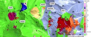
Figure 3: Numbered structural blocks and geological units. Black dots are the drill collars.
Figure 4: Copper Equivalent (CuEq%) grade shells in plan view.
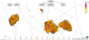
Figure 4: Copper Equivalent (CuEq%) grade shells in plan view.
Figure 5: Copper Equivalent (CuEq%) grade shells in section view.
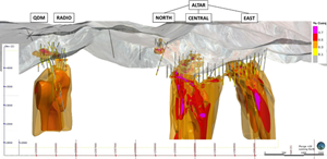
Figure 5: Copper Equivalent (CuEq%) grade shells in section view.
Figure 6: Secondary (supergene) copper (Cu%) plan view map.
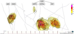
Figure 6: Secondary (supergene) copper (Cu%) plan view map.
Figure 7: Secondary (supergene) copper (Cu%) cross-section map.
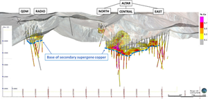
Figure 7: Secondary (supergene) copper (Cu%) cross-section map.
Figure 8: Distribution of sulphide minerals.
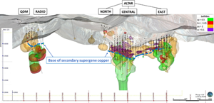
Figure 8: Distribution of sulphide minerals.
Figure 9: Arsenic distribution relation to the 0.5% Cu (black dashed line) and 0.7% Cu (magenta dashed line) grade shells. Note that most of the high arsenic is found within the leach cap and secondary (supergene) copper zones.
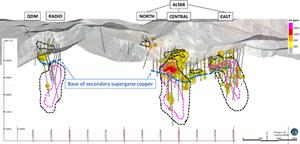
Figure 9: Arsenic distribution relation to the 0.5% Cu (black dashed line) and 0.7% Cu (magenta dashed line) grade shells. Note that most of the high arsenic is found within the leach cap and secondary (supergene) copper zones.
Figure 10: Potassic alteration (PK+PB) in relation to the 0.5% Cu (black dashed line) and 0.7% Cu (magenta dashed line) grade shells.
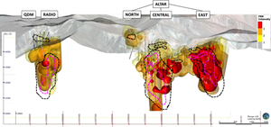
Figure 10: Potassic alteration (PK+PB) in relation to the 0.5% Cu (black dashed line) and 0.7% Cu (magenta dashed line) grade shells.
Figure 11: Green sericite-chlorite (GSC) alteration in relation to the 0.5% Cu (black dashed line) and 0.7% Cu (magenta dashed line) grade shells.
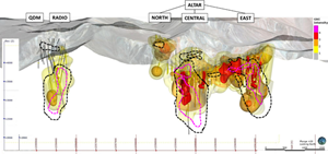
Figure 11: Green sericite-chlorite (GSC) alteration in relation to the 0.5% Cu (black dashed line) and 0.7% Cu (magenta dashed line) grade shells.
2021 GlobeNewswire, Inc., source

