“The spring RC drilling program at Angilak showcases the potential for zones such as Dipole, Yat and now J4 West to host high-grade, near-surface, basement-hosted uranium deposits, with multiple zones of near-surface radioactivity intersected in 22 of 27 holes with vertical depths of radioactive intersections ranging between 9 and 110 metres,” stated ValOre’s VP of Exploration,
Angilak 2022 RC Drilling Highlights:
- 26 RC drill holes in 3,063 metres (“m”) drilled to date from 13 drill sites at Dipole (17 holes), Yat (4 holes) and J4 West (5 holes, 6th hole on-going) targets;
- Multiple zones of near-surface radioactivity intersected in 14 of 17 holes at Dipole, 4 of 4 holes at Yat and 4 of 5 holes at J4 West, with vertical depths of radioactive intersections ranging from 9 m to 110 m;
- Dipole, Yat and J4 West remain largely open along strike and at depth;
- Ground VLF-EM and magnetics program is complete, totaling 1,547 line-kilometres (“ln-km”) and 15,481 hectares (“ha”);
- Total of 401 samples (611 m) from 22 holes have been collected for assay, to date;
- Timing and specific areas of focus for the follow up diamond drill core program in Q3 will be announced upon receipt and review of assay results.
J4 West Target
- J4 West target (“J4W”), located 280 m west of the J4 uranium deposit, which hosts an inferred resource estimate of 14.4 Mlbs U3O8 grading 0.8% U3O8;
- 2022 J4W drilling has tested a strike length of 400 m of a 1-km-long EM conductor, with 2 RC holes drilled from each of three sites spaced 200 m apart;
- RC22-J4W-001 returned a peak CPS value of 22,146 at ~36 m vertical depth, within a broader zone of 12,118 CPS over 4.6 m.
The J4 West (“J4W”) target, formerly know as the
2022 Drilling at J4 West
Drilling to date in 2022 at J4W was conducted from three sites spaced 200 m apart, with 2 RC holes drilled at each pad, testing a strike length of 400 m in between the area of previous drilling and the sinistral structure to the east. All holes to date have intercepted strong, shallow intervals of radioactivity, including a peak CPS value of 22,146 in RC22-J4W-001 at ~36 m vertical depth, within a broader zone of 12,118 CPS over 4.6 m (Table 1, Figure 1). A final drill hole is in progress.
Results to date from J4W are highly encouraging, and support the interpretation of a high-grade, shallow uranium deposit being off-set from J4, and continuing along the 1-km-long conductor to the west.
Figure 1: Plan Map of J4 West Target, and J4-Ray Uranium Deposits
https://www.globenewswire.com/NewsRoom/AttachmentNg/d9521542-cf83-41ea-b89e-f6ae3cf36c65
2022 RC Drilling at Yat
A total of 4 RC holes (382.52 m) were drilled at Yat in 2022, with all four holes intercepting between 1 to 4 zones of near-surface, anomalous radioactivity (Table 1), up to a maximum value of 5,013 CPS in hole RC22-YAT-002. Three of these holes were previously released (CLICK HERE for news release dated
The final hole, RC22-YAT-004, drilled through 4 distinct radioactive zones within a package of locally graphitic basaltic, trachytic and andesitic volcanic rocks, locally mineralized with sulfides (pyrite, chalcopyrite), copper oxides (malachite, azurite) and native copper.
2022 RC Drilling at Dipole
A total of 17 RC holes (2,141.21 m) were drilled at Dipole in 2022, with all 14 of 17 holes intercepting between 2 to 4 zones of near-surface, anomalous radioactivity (Table 1), up to a maximum value of 65,535 CPS in RC22-DP-005. All 2022 Dipole RC holes are summarized in news releases dated
Table 1: 2022 RC Drilling Results to Date (Scintillometer CPS Radioactivity)
| Target | Hole ID | EOH (m) | Samples | Max CPS | Zone 1* | Zone 2* | Zone 3* | Zone 4* |
| Yat | RC22-YAT-004 | 109.73 | 71 | 1,964 | 9.14-24.38 m @ Max CPS: 1,146 Avg CPS: 762 | 24.38-25.91 m @ 375 CPS | 33.53-44.20 m @ Max CPS: 1,964 Avg CPS: 1,100 | 56.39-65.53 m @ Max CPS: 384 Avg CPS: 371 |
| J4W | RC22-J4W-001 | 109.73 | 6 | 22,146 | 4.57-6.10 m @ 1015 CPS | 48.77-53.34 m @ Max CPS: 22,146 Avg CPS: 12,118 | 64.01-67.06 m @ Max CPS: 371 Avg CPS: 351 | |
| J4W | RC22-J4W-002 | 129.54 | 5 | 13,929 | 50.29-51.82 m @ 1297 CPS | 56.39-60.96 m @ Max CPS: 13,929 Avg CPS: 4,899 | 91.44-92.96 m @ 355 CPS | |
| J4W | RC22-J4W-003 | 80.77 | 3 | 4,788 | 56.39-60.96 m @ Max CPS: 4,788 Avg CPS: 1,893 | |||
| J4W | RC22-J4W-004 | 109.73 | 1 | 2,248 | 73.15-74.68 m @ 2248 CPS | |||
| J4W | RC22-J4W-005 | 109.73 | 0 | Background | ||||
| J4W | RC22-J4W-006 | On-going | TBD | TBD | ||||
| TOTALS (to date) | 2302.75 | 315 | ||||||
* All zone interval measurements are metres (“m”) down-hole, and true widths are yet to be determined
2022 Ground VLF-EM and Magnetics
A total of 1,547 line-km covering 15,481 ha of prospective area was surveyed in the 2022 ground geophysics campaign. The VLF-EM and magnetics data have been compiled and processed, which included the generation of 3D inversion models to aid in future drill targeting (Figure 2).
The program was planned for 2,400 line-km but was cut short due to reduced snow and deteriorating ice conditions. The remaining un-surveyed area will be considered for a spring 2023 ground geophysics program.
Figure 2: Regional Map of Angilak Property, Summarizing 2022 Exploration to Date
https://www.globenewswire.com/NewsRoom/AttachmentNg/eeaf71d8-7231-46c5-ac6f-0dffd5c40ad0
About Angilak
The 59,483-hectare Angilak Property is situated in the mining- and exploration-friendly Nunavut Territory,
The Lac 50 NI 43-101 Technical Report (effective date
- 43.3 Mlbs U3O8 in 2,831,000 tonnes grading 0.69% U3O8. CLICK HERE for a summary table of the Lac 50 Trend inferred resource estimate;
- Supported by 351 resource delineation drill holes totaling 62,023 metres (“m”);
- Metallurgical results for Lac 50 demonstrate high uranium recoveries and rapid leach kinetics. See news releases:
February 28, 2013 ,September 11, 2013 andFebruary 27, 2014 ; - Lac 50 Trend is a 15 kilometre (“km”) by 3 km area with excellent potential for resource growth and new discoveries;
- Uranium mineralization starts at surface, and has been drilled to 380 m vertical depth;
CLICK HERE for ValOre’s
CLICK HERE for ValOre’s
Qualified Person (“QP”)
The technical information in this news release has been prepared in accordance with Canadian regulatory requirements set out in NI 43-101 and reviewed and approved by
Information related to the independent Angilak mineral resource estimate has been approved by
Information related to the independent
About
In
Comprehensive exploration programs have demonstrated the "District Scale" potential of ValOre’s Angilak Property in Nunavut Territory,
ValOre’s team has forged strong relationships with sophisticated resource sector investors and partner
On behalf of the Board of Directors,
“Jim Paterson”
For further information about
Neither the
This news release contains “forward-looking statements” within the meaning of applicable securities laws. Although ValOre believes that the expectations reflected in its forward-looking statements are reasonable, such statements have been based on factors and assumptions concerning future events that may prove to be inaccurate. These factors and assumptions are based upon currently available information to ValOre. Such statements are subject to known and unknown risks, uncertainties and other factors that could influence actual results or events and cause actual results or events to differ materially from those stated, anticipated or implied in the forward-looking statements. A number of important factors including those set forth in other public filings could cause actual outcomes and results to differ materially from those expressed in these forward-looking statements. Factors that could cause the actual results to differ materially from those in forward-looking statements include the future operations of ValOre and economic factors. Readers are cautioned to not place undue reliance on forward-looking statements. The statements in this press release are made as of the date of this release and, except as required by applicable law, ValOre does not undertake any obligation to publicly update or to revise any of the included forward-looking statements, whether as a result of new information, future events or otherwise. ValOre undertakes no obligation to comment on analyses, expectations or statements made by third parties in respect of ValOre, or its financial or operating results or (as applicable), their securities.

Figure 1: Plan Map of J4 West Target, and J4-Ray Uranium Deposits
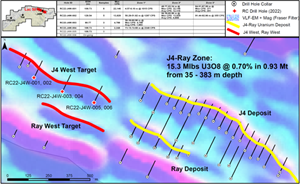
Figure 1: Plan Map of J4 West Target, and J4-Ray Uranium Deposits
Figure 2: Regional Map of Angilak Property, Summarizing 2022 Exploration to Date
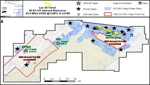
Figure 2: Regional Map of Angilak Property, Summarizing 2022 Exploration to Date
2022 GlobeNewswire, Inc., source

