“RC drilling success at Dipole and Yat this season demonstrates the potential for these zones to host high-grade, near-surface, basement-hosted uranium deposits,” stated ValOre’s VP of Exploration,
- Twenty RC drill holes in 2,141 metres (“m”) drilled to date from 10 drill sites at Dipole (17 holes) and Yat targets (3 holes);
- Multiple zones of near-surface radioactivity intersected in 14 of 17 holes at Dipole and 3 of 3 holes at Yat (Table 1);
- RC drilling at Dipole has extended the known strike extent of the mineralized structure from 150 m to 650 m;
- Radioactive intervals are shallow, with vertical depths of the intersections ranging from 9 m to 110 m below surface;
- RC drilling continues at the Yat target (“Yat”), located 10 kilometres (“km”) to the northeast;
- Prospecting and trenching at Yat in 2015 and 2016 yielded high-grade polymetallic (U-Pd-Pt-Au-Cu-Ag) rock samples which assayed up to 23% U3O8, 58 g/t Pd, 7.8 g/t Pt, 211 g/t Au, 22% Cu, and 3,200 g/t Ag;
- Yat program has been expanded due to strong preliminary results, with intervals of anomalous radioactivity intercepted in 3 of 3 holes, up to a maximum of 5,013 counts per second (“CPS”);
- Total of 315 samples (480 m total) from 17 holes have been collected for assay, to date;
- Dipole and Yat remain open in both directions and at depth.
Table 1: 2022 RC Drilling Results to Date (Scintillometer CPS Radioactivity)
| Target | Hole ID | EOH (m) | Samples | Max CPS | Zone 1* | Zone 2* | Zone 3* | Zone 4* |
| Dipole | RC22-DP-001* | 100.58 | 2 | 1,020 | 64.01-65.5 m @ 560 CPS | 70.10-71.6 m @ 1,020 CPS | ||
| Dipole | RC22-DP-002* | 128.02 | 6 | 5,320 | 36.58-38.10 m @ 2,280 CPS | 73.15-80.77 m @ Max CPS: 5,320 Avg CPS: 2,242 | ||
| Dipole | RC22-DP-003* | 100.58 | 2 | 590 | 65.53-67.06 m @ 590 CPS | 85.34-86.87 m @ 560 CPS | ||
| Dipole | RC22-DP-004* | 120.4 | 2 | 630 | 73.20-77.72 m @ 630 CPS | 97.54-99.06 m @ 520 CPS | ||
| Dipole | RC22-DP-005* | 111.25 | 13 | 65,535 | 30.48-35.05 m @ Max CPS: 15,380 Avg CPS: 5648 | 47.24-54.86 m @ Max CPS: 65,535 (maxed-out Scint) Avg CPS: 17,270 | 57.91-62.48 m @ Max CPS: 773 Avg CPS: 706 | 68.58-73.15 m @ Max CPS: 722 Avg CPS: 550 |
| Dipole | RC22-DP-006* | 111.25 | 11 | 4,505 | 47.24-50.29 m @ Max CPS: 4,505 Avg CPS: 2,518 CPS | 60.96-62.48 m @ 630 CPS 67.06-68.58 m @ 985 CPS | 76.20-82.30 m @ Max CPS: 3110 Avg CPS: 1,246 | 91.44-96.01 m @ Max CPS: 1,750 Avg: CPS 892 |
| Dipole | RC22-DP-007 | 182.88 | 33 | 26,580 | 65.53-70.10 m @ Max CPS: 15,400 Avg CPS: 8,486 | 92.96-99.06 m @ Max CPS: 26,580 Avg CPS: 10,080 | 109.73-124.97 m @ Max CPS: 24,550 Avg CPS: 3,561 | 129.54-153.92 m @ Max CPS: 4,755 Avg CPS: 2,689 |
| Dipole | RC22-DP-008 | 100.58 | 16 | 865 | 47.24-54.86 m @ Max CPS: 865 Avg CPS: 570 | 57.91-73.15 m @ Max CPS: 685 Avg CPS: 484. | 86.87-88.39 m @ 477 CPS | |
| Dipole | RC22-DP-009 | 120.4 | 21 | 1,465 | 53.34-82.30 m @ Max CPS: 1,465 Avg CPS: 528 | 88.39-91.44 m @ Max CPS: 455 Avg CPS: 303 | ||
| Dipole | RC22-DP-010 | 100.58 | 8 | 915 | 74.68-82.30 m @ Max CPS: 485 Avg CPS: 380 | 91.44-96.01 m @ Max CPS: 915 Avg CPS: 633 | ||
| Dipole | RC22-DP-011 | 121.92 | 4 | 484 | 80.77-82.30 m @ Max CPS: 435 Avg CPS: 366 | 97.54-100.58 m @ Max CPS 484 and Avg CPS: 384 | ||
| Dipole | RC22-DP-012 | 103.63 | 3 | 375 | 22.86-24.38 m @ CPS: 351 | 91.44-92.96 m @ Max CPS: 375 Avg CPS: 372 | ||
| Dipole | RC22-DP-013 | 137.16 | 0 | 175 | ||||
| Dipole | RC22-DP-014 | 160.02 | 6 | 6,500 | 48.77-50.29 m @ 455 CPS | 80.77-85.34 m @ Max CPS: 6,500 Avg CPS:2,500 | 126.49-129.54 m @ Max CPS: 2690 Avg CPS:1578 | |
| Dipole | RC22-DP-015 | 201.17 | 16 | 3,300 | 76.20-77.72 m @ 3,300 CPS | 85.34-89.92 m @ Max CPS: 2,600 Avg CPS:1,200 | 121.92-134.11 m @ Max CPS: 1,957 Avg CPS: 864 | 170.69-181.36 m @ Max CPS: 1,223 Avg CPS: 600 |
| Dipole | RC22-DP-016 | 100.58 | 0 | 120 | ||||
| Dipole | RC22-DP-017 | 140.21 | 0 | 179 | ||||
| Yat | RC22-YAT-001 | 80.77 | 50 | 1,236 | 15.24-22.86 m @ Max CPS: 1,236 Avg CPS:756 | 41.15-42.67 m @ 355 CPS | ||
| Yat | RC22-YAT-002 | 80.77 | 50 | 5,013 | 9.14-10.67 m @ 467 CPS | 19.81-21.34 m @ 467 CPS | 28.96-32.00 m @ Max CPS: 5,013 (with 356 shoulder) | 44.20-45.72 m @ 356 CPS |
| Yat | RC22-YAT-003 | 111.25 | 72 | 392 | 67.06-68.58 m @ 392 CPS | |||
| TOTALS (to date) | 2302.75 | 315 | ||||||
* Previously release hole, CLICK HERE for news release dated
** All zone interval measurements are metres (“m”) down-hole, and true widths are yet to be determined
2022 RC Drilling at Dipole
The main zone at Dipole was tested with 15 RC drill holes over 650 m of strike length in 2022, with 14 of 15 holes intersecting anomalous radioactivity (>350 CPS), 10 holes with intervals exceeding 1,000 CPS and 7 holes over 3,300 CPS (Figure 1). A maximum of 65,535 CPS was drilled in hole RC22-DP-005, a reading which maxed-out the handheld scintillometer. Assays for the 143 Dipole samples (217 m) remain pending.
All main zone drill pad locations produced a minimum of 2 and a maximum of 4 intervals of radiation, including the following highlight from hole RC22-DP-007 (Figure 2):
- Zone 1: 4.57 m averaging 8,486 CPS from 65.53 m (max 15,400 CPS)
- Zone 2: 6.64 m averaging 10,080 CPS from 92.96 m (max 26,580 CPS)
- Zone 3: 15.24 m averaging 3,561 CPS from 109.73 m (max 24,550 CPS)
- Zone 4: 24.38 m averaging 2,689 CPS from 129.54 m (max 4,755 CPS)
2022 VLF-EM ground surveys have delineated the target Dipole conductor for approximately 9 km, with strong uranium-in-soil anomalies remaining open in both directions of strike. Soil sampling along-trend will commence in July, and the core drill rig will further test the high-grade Dipole structure at depth and along strike in both directions.
One regional reconnaissance RC drill pad was located 1,250 m to the northwest of the main zone, where two 2022 holes were drilled. Both RC22-DP-016 and -017 only returned background radioactivity values, and thus will not receive follow-up. For more information regarding the Dipole target, CLICK HERE for news release dated
Figure 1: Dipole target map, showing locations of the 2015 core holes, 2022 RC holes, prospective VLF-EM conductor, and uranium-in-soils samples.
Figure 1 is available at https://www.globenewswire.com/NewsRoom/AttachmentNg/c6da78ee-29b4-458b-a27c-e6a1db986cd7
Figure 2: Cross Section A-A’, Dipole Target
Figure 2 is available at https://www.globenewswire.com/NewsRoom/AttachmentNg/0edac4a9-4afa-4303-886d-424d89607f39
Yat is located near the northern margin of the
Work by ValOre between 2007 and 2012 included ground gravity, Mag-VLF surveys, and four shallow reconnaissance RC holes that did not intersect significant uranium mineralization. Subsequent soil sampling and prospecting in 2015 served to delineate uranium and silver soil anomalies running parallel to a discreet 1.6-km-long EM conductor that strikes northeast through the centre of the magnetic low.
A 2015 grab sample from brecciated quartz-carbonate veined glacial float collected on the southeast margin of the Yat magnetic response returned the highest precious metal assays ever reported from the Angilak Property with 1.82% U3O8, 6.8% Cu, 211 g/t Au, 80,900 g/t Ag, 3.1 g/t Pt and 6.7 g/t Pd (CLICK HERE for news release
In
- Channel sample 18924 from Trench KIV-16-T03:
2.50% U3O8, 16.2% Cu, 417 g/t Ag and 1.3 g/t Au over a width of 0.5 m - Channel sample A00560 from Trench KIV-PO-T05:
0.32% U3O8, 0.10% Cu, 373 g/t Ag, 2.9 g/t Au and 6.4 g/t Pd across a width of 0.65 m - Grab sample A00619:
23.6% U3O8, 22.7% Cu, 879 g/t Ag and 5.3 g/t Au - Grab sample 18939:
3.0% U3O8, 1.3% Cu, 3200 g/t Ag, 43.3 g/t Au, 7.8 g/t Pt and 56.3 g/t Pd
2022 RC Drilling at Yat
The main Yat zone which produced the high-grade polymetallic boulder and trench channel samples has been tested with 3 RC holes (273 m) from 2 drill sites to date in 2022, with all holes intersecting zones of anomalous radioactivity. Highlight drill hole 22RC-YAT-002 returned 3 discrete radioactive zones between 15.25 to 32.00 m depth, with a maximum CPS value of 5,013 from 28.96-30.00 m (Table 1). A fourth drill hole is in process.
2022 RC holes are designed to drill under the high-grade trench assays, testing for continuity of mineralization at depth. Given the potential for Pd-Pt-Au mineralization being unassociated with radioactivity, every metre from the 2022 Yat RC holes will be sampled for assay.
Figure 3: Plan map regional Yat target area, showing uranium-in-soils anomaly, coincident VLF-EM conductor, high-grade rock samples, and drilling.
Figure 3 is available at https://www.globenewswire.com/NewsRoom/AttachmentNg/66483014-8e4b-46f3-a96c-56c947a55ed0
Figure 4: Plan map of main zone at Yat, with assay results from 2015 prospecting and 2016 trenching programs, and locations of historical and 2022 RC drill holes.
Figure 4 is available at https://www.globenewswire.com/NewsRoom/AttachmentNg/fce73610-2978-4e9f-a8e2-e03b448416f2
About Angilak
The 59,483-hectare Angilak Property is situated in the mining- and exploration-friendly Nunavut Territory,
The Lac 50 NI 43-101 Technical Report (effective date
- 43.3 Mlbs U3O8 in 2,831,000 tonnes grading 0.69% U3O8. CLICK HERE for a summary table of the Lac 50 Trend inferred resource estimate;
- Supported by 351 resource delineation drill holes totaling 62,023 metres (“m”);
- Metallurgical results for Lac 50 demonstrate high uranium recoveries and rapid leach kinetics. See news releases:
February 28, 2013 ,September 11, 2013 andFebruary 27, 2014 ; - Lac 50 Trend is a 15 kilometre (“km”) by 3 km area with excellent potential for resource growth and new discoveries;
- Uranium mineralization starts at surface, and has been drilled to 380 m vertical depth;
CLICK HERE for ValOre’s
CLICK HERE for ValOre’s
Qualified Person (“QP”)
The technical information in this news release has been prepared in accordance with Canadian regulatory requirements set out in NI 43-101 and reviewed and approved by
Information related to the independent Angilak mineral resource estimate has been approved by
Information related to the independent
About
In
Comprehensive exploration programs have demonstrated the "District Scale" potential of ValOre’s Angilak Property in Nunavut Territory,
ValOre’s team has forged strong relationships with sophisticated resource sector investors and partner
On behalf of the Board of Directors,
“Jim Paterson”
For further information about
Neither the
This news release contains “forward-looking statements” within the meaning of applicable securities laws. Although ValOre believes that the expectations reflected in its forward-looking statements are reasonable, such statements have been based on factors and assumptions concerning future events that may prove to be inaccurate. These factors and assumptions are based upon currently available information to ValOre. Such statements are subject to known and unknown risks, uncertainties and other factors that could influence actual results or events and cause actual results or events to differ materially from those stated, anticipated or implied in the forward-looking statements. A number of important factors including those set forth in other public filings could cause actual outcomes and results to differ materially from those expressed in these forward-looking statements. Factors that could cause the actual results to differ materially from those in forward-looking statements include the future operations of ValOre and economic factors. Readers are cautioned to not place undue reliance on forward-looking statements. The statements in this press release are made as of the date of this release and, except as required by applicable law, ValOre does not undertake any obligation to publicly update or to revise any of the included forward-looking statements, whether as a result of new information, future events or otherwise. ValOre undertakes no obligation to comment on analyses, expectations or statements made by third parties in respect of ValOre, or its financial or operating results or (as applicable), their securities.

Dipole target map
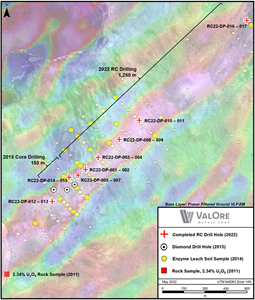
Figure 1: Dipole target map, showing locations of the 2015 core holes, 2022 RC holes, prospective VLF-EM conductor, and uranium-in-soils samples.
Cross Section A-A’, Dipole Target
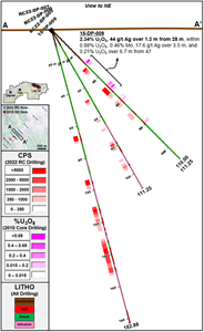
Figure 2: Cross Section A-A’, Dipole Target
Plan map regional Yat target area
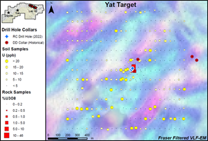
Figure 3: Plan map regional Yat target area, showing uranium-in-soils anomaly, coincident VLF-EM conductor, high-grade rock samples, and drilling.
Plan map of main zone at Yat
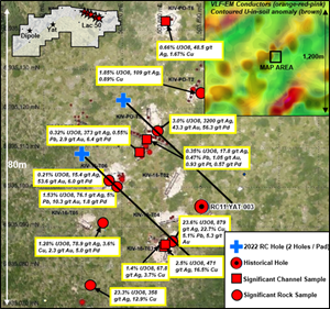
Figure 4: Plan map of main zone at Yat, with assay results from 2015 prospecting and 2016 trenching programs, and locations of historical and 2022 RC drill holes.
2022 GlobeNewswire, Inc., source

