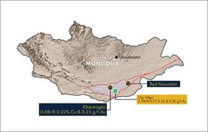
TORONTO, Sept. 28, 2021 (GLOBE NEWSWIRE) -- Xanadu Mines Ltd (ASX: XAM, TSX: XAM) (Xanadu or the Company) is pleased to provide an exploration update for the Red Mountain copper-gold porphyry district, a joint venture with Japan Oil, Gas and Metals National Corporation (JOGMEC). Red Mountain is located within the Dornogovi Province of southern Mongolia, approximately 420km southeast of Ulaanbaatar and 70km west of the provincial centre of Sainshand.
Highlights
- 3,000m diamond drilling program completed at Red Mountain, with targeting focussed on near surface high-grade bornite mineralisation at Stairy and nearby larger-scale porphyry IP targets
- Assays returned for 1,865m, with silver-rich, high-grade copper results in several drill holes, including:
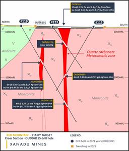
° OUDDH115 4m @ 7.34% Cu, 29.3g/t Ag from 60m
• Including 1m @ 28.9% Cu, 114g/t Ag from 62m
° OUDDH119 8m @ 1.31% Cu, 7.00g/t Ag from 94m
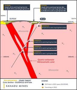
° OUDDH112 4m @ 1.98% Cu, 9.15g/t Ag from 40m
- Mineralised zones primarily comprised of massive bornite and bornite, along with trace chalcocite
- Structural modelling underway to understand orientation for targeting additional high-grade bornite
- Assays pending for remaining 1,135m, expected within the next two weeks
Xanadu’s Chief Executive Officer, Dr Andrew Stewart, said “We are very excited to see shallow, high-grade bornite mineralisation that is comparable to our Stairy drilling results from earlier this year1. This confirms the presence of sub-vertical mineralised structures up to twenty-four meters wide that potentially extend beyond a kilometre. Importantly, our latest geological interpretation suggests these may be linked to a large-scale porphyry system at depth. Red Mountain district, particularly Stairy, continues to improve, laying a strong foundation for future exploration.”
Stairy Drilling Results
Approximately 1,600 metres of the 3,000 metre Red Mountain drilling program was designed to obtain geological (structural) data relating to mineralised zones identified in recent trenching results2 at Stairy. The remaining 1,400 metres was designed to target large-scale porphyry IP targets.
Multiple intercepts of strong copper mineralisation were encountered in the first batch of assays received, comprising 1,812 metres (Appendix 1: Tables 1 and 2), including drill holes OUDDH112, OUDDH115 and OUDDH119 (Figures 1, 2, 3 and 4). These results indicate extensions to mineralised zones identified in historic trenches. More importantly, the results provide greater structural and pathfinder information for better targeting high-grade bornite zones in future drilling programs.
| Hole ID | From | Interval | Cu | Ag |
| OUDDH112 | 0 | 8m | 0.15 | % | 0.96g/t |
| and | 30m | 4m | 0.16 | % | 0.80g/t |
| and | 40m | 4m | 1.98 | % | 9.15g/t |
| and | 48m | 4m | 0.19 | % | 1.20g/t |
| Hole ID | From | Interval | Cu | Ag |
| OUDDH115 | 60m | 4m | 7.34 | % | 29.29g/t |
| including | 61.5m | 1m | 28.90 | % | 114.0g/t |
| Hole ID | From | Interval | Cu | Ag |
| OUDDH119 | 42m | 6m | 0.27 | % | 0.55g/t |
| including | 42m | 4m | 0.36 | % | 0.70g/t |
| and | 94m | 8m | 1.31 | % | 7.00g/t |
| including | 94m | 6m | 1.72 | % | 9.17g/t |
True mineralised widths will generally be narrower than those reported. See disclosure in JORC Tables attached in Appendix 3.
The next stage of Red Mountain exploration will be developed by Xanadu and its partner JOGMEC using results reported in this announcement and assays pending. This follow-up targeting program will be announced in due course.
FIGURE 1: Cross Section OUDDH112 is available at:
https://www.globenewswire.com/NewsRoom/AttachmentNg/8007eccf-f001-4f88-be94-9c1a6ba25398
FIGURE 2: Cross Section OUDDH115 and OUDDH119 is available at:
https://www.globenewswire.com/NewsRoom/AttachmentNg/eff429bc-a21b-4042-bd27-a60c4311f3bc
FIGURE 3: Trenching Results at Stairy, showing surface high-grade mineralisation3,4 is available at:
https://www.globenewswire.com/NewsRoom/AttachmentNg/4876097c-f386-4d70-979e-973521c38f55
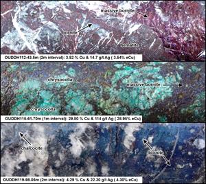
FIGURE 4: HQ Core images from Stairy Drilling. Core is 6.4cm high is available at:
https://www.globenewswire.com/NewsRoom/AttachmentNg/a49c8d51-0030-42a5-9f6b-ba09858fab26
About Stairy
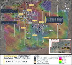
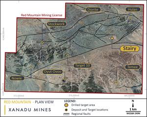
The Stairy prospect consists of a 1.5km by 1km zone of sheeted mineralised structures hosted within the Stairy Intrusive in central eastern portion of Red Mountain Mining Lease (Figure 5). Structures are interpreted to be sub-vertical, up to twenty-four meters wide and can extend beyond a kilometre.
Copper mineralisation at Stairy consists of bornite and chalcopyrite sulphide with quartz carbonate fill. Current geological interpretations suggest these sheeted structures may be linked to a large-scale porphyry system at depth.
FIGURE 5: Red Mountain Mining Licence, showing ground Landsat data and priority target locations is available at:
https://www.globenewswire.com/NewsRoom/AttachmentNg/7518ff65-5da0-4a5c-ad76-8a1d2af0a895
About Red Mountain
The Red Mountain district is located within the Dornogovi Province of southern Mongolia, approximately 420 kilometres southeast of Ulaanbaatar (Figure 6) and is a joint venture between Xanadu and JOGMEC, in which JOGMEC may earn up to 51% beneficial interest in the project by sole funding up to $US7.2 million in exploration expenditure over 4 years, commencing April 2020.
Red Mountain covers approximately 57 square kilometres in a frontier terrane with significant mineral endowment, and it has a granted 30-year mining licence. Red Mountain comprises a cluster of outcropping mineralising porphyry intrusions which display features typically found in the shallower parts of porphyry systems where narrow dykes and patchy mineralisation branch out above a mineralised stock. This includes multiple porphyry copper-gold centres, mineralised tourmaline breccia pipes copper-gold/base metal skarns and high-grade epithermal gold veins.
FIGURE 6: Location of the Red Mountain district in the South Gobi porphyry copper belt 5 is available at:
https://www.globenewswire.com/NewsRoom/AttachmentNg/8583f2c4-eff6-4c5e-9c5d-42e1d440fa45
About Xanadu Mines
Xanadu is an ASX and TSX listed Exploration company operating in Mongolia. We give investors exposure to globally significant, large scale copper-gold discoveries and low-cost inventory growth. Xanadu maintains a portfolio of exploration projects and remains one of the few junior explorers on the ASX or TSX who control a globally significant copper-gold deposit in our flagship Kharmagtai project. For information on Xanadu visit: www.xanadumines.com.
For further information, please contact:
Andrew Stewart
Chief Executive Officer
T: +61 2 8280 7497
M: +61 409 819 922
E: Andrew.stewart@xanadumines.com
W: www.xanadumines.com
This Announcement was authorised for release by Xanadu’s Board of Directors.
Appendix 1: Drilling Results
Table 1: Drill hole locations
| Hole ID | Prospect | East | North | RL | Azimuth (°) | Inc (°) | Depth (m) |
| OUDDH106 | Stairy | 378390 | 4939816 | 1055 | 0 | -58 | 145.0 |
| OUDDH107 | Stairy | 378426 | 4939852 | 1055 | 0 | -58 | 95.0 |
| OUDDH108 | Stairy | 378342 | 4939821 | 1055 | 0 | -58 | 75.0 |
| OUDDH109 | Stairy | 378388 | 4939917 | 1056 | 180 | -60 | 125.0 |
| OUDDH110 | Stairy | 378392 | 4939522 | 1051 | 0 | -58 | 75.5 |
| OUDDH111 | Stairy | 378598 | 4939602 | 1049 | 0 | -58 | 75.5 |
| OUDDH112 | Stairy | 378699 | 4939648 | 1050 | 0 | -58 | 75.5 |
| OUDDH113 | Stairy | 378393 | 4939413 | 1049 | 0 | -58 | 75.0 |
| OUDDH114 | Stairy | 378644 | 4939610 | 1049 | 0 | -58 | 75.5 |
| OUDDH115 | Stairy | 378237 | 4939758 | 1056 | 0 | -60 | 80.5 |
| OUDDH116 | Stairy | 378995 | 4939675 | 1044 | 0 | -60 | 75.0 |
| OUDDH117 | Stairy | 378396 | 4939764 | 1054 | 0 | -58 | 85.0 |
| OUDDH118 | Stairy | 378451 | 4939784 | 1054 | 0 | -58 | 75.0 |
| OUDDH119 | Stairy | 378239 | 4939837 | 1056 | 180 | -60 | 120.0 |
| OUDDH120 | Stairy | 378285 | 4939774 | 1055 | 0 | -58 | 85.0 |
| OUDDH121 | Stairy | 378473 | 4939874 | 1055 | 0 | -58 | 75.0 |
| OUDDH122 | Stairy | 378501 | 4939846 | 1054 | 0 | -58 | 75.0 |
| OUDDH123 | Stairy | 378246 | 4939803 | 1056 | 180 | -55 | 55.0 |
| OUDDH124 | Stairy | 378228 | 4939804 | 1056 | 180 | -55 | 55.0 |
| OUDDH125 | Bavuu | 376700 | 4939549 | 1081 | 0 | -75 | 400.0 |
| OUDDH126 | Diorite | 378398 | 4940329 | 1064 | 180 | -75 | 400.0 |
| OUDDH127 | Diorite | 377800 | 4940430 | 1071 | 0 | -65 | 550.0 |
Table 2: Significant drill results
| Hole ID | Prospect | From (m) | To (m) | Interval (m) | Cu (%) | Ag (g/t) |
| OUDDH106 | Stairy | 8 | 12 | 4 | 0.19 | 0.90 |
| and | | 42 | 45.4 | 3.4 | 0.58 | 3.18 |
| and | | 56 | 64 | 8 | 0.29 | 1.39 |
| including | | 56 | 60 | 4 | 0.40 | 2.20 |
| OUDDH107 | Stairy | 68 | 74 | 6 | 0.20 | 0.90 |
| OUDDH108 | Stairy | 0 | 4 | 4 | 0.12 | 0.38 |
| and | | 10 | 14 | 4 | 0.34 | 1.85 |
| and | | 26 | 32 | 6 | 0.51 | 2.27 |
| and | | 40 | 44 | 4 | 0.45 | 2.50 |
| and | | 68 | 72 | 4 | 0.15 | 0.53 |
| OUDDH109 | Stairy | 102 | 108 | 6 | 0.28 | 1.27 |
| and | | 118 | 124 | 6 | 0.49 | 2.37 |
| OUDDH110 | Stairy | 18 | 24 | 6 | 0.15 | 0.67 |
| and | | 66 | 72 | 6 | 0.60 | 3.10 |
| including | | 68 | 72 | 4 | 0.75 | 3.85 |
| OUDDH112 | | 0 | 8 | 8 | 0.15 | 0.96 |
| and | | 30 | 34 | 4 | 0.16 | 0.80 |
| and | | 40 | 44 | 4 | 1.98 | 9.15 |
| and | | 48 | 52 | 4 | 0.20 | 1.20 |
| OUDDH113 | Stairy | 16 | 26 | 10 | 0.24 | 1.26 |
| including | | 32 | 54 | 22 | 0.21 | 1.03 |
| OUDDH115 | Stairy | 60 | 64 | 4 | 7.34 | 29.29 |
| including | | 61.5 | 62.5 | 1 | 28.90 | 114.00 |
| OUDDH117 | Stairy | 70 | 74 | 4 | 0.14 | 0.55 |
| OUDDH119 | Stairy | 42 | 48 | 6 | 0.27 | 0.55 |
| including | | 42 | 46 | 4 | 0.36 | 0.70 |
| and | | 94 | 102 | 8 | 1.31 | 7.00 |
| including | | 94 | 100 | 6 | 1.72 | 9.17 |
| OUDDH120 | Stairy | 72 | 76 | 4 | 0.30 | 1.13 |
| OUDDH121 | Stairy | 42 | 48 | 6 | 0.39 | 0.40 |
| OUDDH122 | Stairy | Assays pending |
| OUDDH123 | Stairy | Assays pending |
| OUDDH124 | Stairy | Assays pending |
| OUDDH125 | Bavuu | 54 | 72 | 18 | 0.05 | 0.59 |
| OUDDH126 | Diorite | Assays pending |
| OUDDH127 | Diorite | Assays pending |
Appendix 2: Statements and Disclaimers
Competent Person Statement
The information in this announcement that relates to exploration results is based on information compiled by Dr Andrew Stewart, who is responsible for the exploration data, comments on exploration target sizes, QA/QC and geological interpretation and information. Dr Stewart, who is an employee of Xanadu and is a Member of the Australasian Institute of Geoscientists, has sufficient experience relevant to the style of mineralisation and type of deposit under consideration and to the activity he is undertaking to qualify as the “Competent Person” as defined in the 2012 Edition of the Australasian Code for Reporting Exploration Results, Mineral Resources and Ore Reserves and the National Instrument 43-101. Dr Stewart consents to the inclusion in the report of the matters based on this information in the form and context in which it appears.
Forward-Looking Statements
Certain statements contained in this Announcement, including information as to the future financial or operating performance of Xanadu and its projects may also include statements which are ‘forward‐looking statements’ that may include, amongst other things, statements regarding targets, estimates and assumptions in respect of mineral reserves and mineral resources and anticipated grades and recovery rates, production and prices, recovery costs and results, capital expenditures and are or may be based on assumptions and estimates related to future technical, economic, market, political, social and other conditions. These ‘forward-looking statements’ are necessarily based upon a number of estimates and assumptions that, while considered reasonable by Xanadu, are inherently subject to significant technical, business, economic, competitive, political and social uncertainties and contingencies and involve known and unknown risks and uncertainties that could cause actual events or results to differ materially from estimated or anticipated events or results reflected in such forward‐looking statements.
Xanadu disclaims any intent or obligation to update publicly or release any revisions to any forward‐looking statements, whether as a result of new information, future events, circumstances or results or otherwise after the date of this Announcement or to reflect the occurrence of unanticipated events, other than required by the Corporations Act 2001 (Cth) and the Listing Rules of the Australian Securities Exchange (ASX) and Toronto Stock Exchange (TSX). The words ‘believe’, ‘expect’, ‘anticipate’, ‘indicate’, ‘contemplate’, ‘target’, ‘plan’, ‘intends’, ‘continue’, ‘budget’, ‘estimate’, ‘may’, ‘will’, ‘schedule’ and similar expressions identify forward‐looking statements.
All ‘forward‐looking statements’ made in this Announcement are qualified by the foregoing cautionary statements. Investors are cautioned that ‘forward‐looking statements’ are not guarantee of future performance and accordingly investors are cautioned not to put undue reliance on ‘forward‐looking statements’ due to the inherent uncertainty therein.
For further information please visit the Xanadu Mines’ Website at www.xanadumines.com.
Appendix 3: Red Mountain Table 1 (JORC 2012)
Set out below is Section 1 and Section 2 of Table 1 under the JORC Code, 2012 Edition for the Red Mountain project. Data provided by Xanadu. This Table 1 updates the JORC Table 1 disclosure dated 5 August 2021.6
1.1 JORC TABLE 1 - SECTION 1 - SAMPLING TECHNIQUES AND DATA
| Criteria | JORC Code explanation | Commentary |
| Sampling techniques | - Nature and quality of sampling (e.g., cut channels, random chips, or specific specialised industry standard measurement tools appropriate to the minerals under investigation, such as down hole gamma sondes, or handheld XRF instruments, etc). These examples should not be taken as limiting the broad meaning of sampling.
- Include reference to measures taken to ensure sample representivity and the appropriate calibration of any measurement tools or systems used.
- Aspects of the determination of mineralisation that are Material to the Public Report.
- In cases where ‘industry standard’ work has been done this would be relatively simple (e.g., ‘reverse circulation drilling was used to obtain 1 m samples from which 3 kg was pulverised to produce a 30 g charge for fire assay’). In other cases, more explanation may be required, such as where there is coarse gold that has inherent sampling problems. Unusual commodities or mineralisation types (e.g., submarine nodules) may warrant disclosure of detailed information.
| - The exploration results are based on diamond drill core samples, reverse circulation (RC) chip samples and channel samples from surface trenches.
- Representative ½ core samples were split from PQ, HQ & NQ diameter diamond drill core on site using rock saws, on a routine two metre sample interval that also honors lithological/intrusive contacts.
- The orientation of the cut line is controlled using the core orientation line ensuring uniformity of core splitting wherever the core has been successfully oriented.
- Sample intervals are defined and subsequently checked by geologists, and sample tags are attached (stapled) to the plastic core trays for every sample interval.
- RC chip samples are ¼ splits from 1m intervals using a 75%:25% riffle splitter to obtain a 3kg sample.
- RC samples are uniform 2m samples formed from the combination of two ¼ split 1m samples.
- Trench samples are collected as 2m composite from 30m above the trench toe.
- Sampling generally honors lithological contacts.
- Trench samples are continuous along the length of the trench
|
| Drilling techniques | - Drill type (e.g., core, reverse circulation, open-hole hammer, rotary air blast, auger, Bangka, sonic, etc.) and details (e.g., core diameter, triple or standard tube, depth of diamond tails, face-sampling bit or other type, whether core is oriented and if so, by what method, etc.).
| - The exploration results are based upon diamond drilling of PQ, HQ and NQ diameters with both standard and triple tube core recovery configurations, RC drilling and surface trenching with channel sampling.
- All drill core drilled by Xanadu has been oriented using the “Reflex Ace” tool.
|
| Drill sample recovery | - Method of recording and assessing core and chip sample recoveries and results assessed.
- Measures taken to maximise sample recovery and ensure representative nature of the samples.
- Whether a relationship exists between sample recovery and grade and whether sample bias may have occurred due to preferential loss/gain of fine/coarse material.
| - Diamond drill core recoveries were assessed using the standard industry (best) practice which involves: removing the core from core trays; reassembling multiple core runs in a v-rail; measuring core lengths with a tape measure, assessing recovery against core block depth measurements and recording any measured core loss for each core run.
- Diamond core recoveries average 97% through mineralization.
- Overall, core quality is good, with minimal core loss. Where there is localized faulting and or fracturing core recoveries decrease, however, this is a very small percentage of the mineralized intersections.
- RC recoveries are measured using whole weight of each 1m intercept measured before splitting
- Analysis of recovery results vs grade shows no significant trends that might indicate sampling bias introduced by variable recovery in fault/fracture zones.
|
| Logging | - Whether core and chip samples have been geologically and geotechnically logged to a level of detail to support appropriate Mineral Resource estimation, mining studies and metallurgical studies.
- Whether logging is qualitative or quantitative in nature. Core (or costean, channel, etc.) photography.
- The total length and percentage of the relevant intersections logged.
| - All drill core is geologically logged by well-trained geologists using a modified “Anaconda-style” logging system methodology. The Anaconda method of logging and mapping is specifically designed for porphyry Cu-Au mineral systems.
- Logging of lithology, alteration and mineralogy is intrinsically qualitative in nature. However, the logging is subsequently supported by 4 Acid ICP-MS (48 element) geochemistry and SWIR spectral mineralogy (facilitating semi-quantitative / calculated mineralogical, lithological and alteration classification) which is integrated with the logging to improve cross section interpretation and 3D geological model development.
- Drill core is also systematically logged for both geotechnical features and geological structures. Where drill core has been successfully oriented, the orientation of structures and geotechnical features are also routinely measured.
- Both wet and dry core photos are taken after core has been logged and marked-up but before drill core has been cut.
|
Sub -
sampling techniques
and sample preparation | - If core, whether cut or sawn and whether quarter, half or all core taken.
- If non-core, whether riffled, tube sampled, rotary split, etc and whether sampled wet or dry.
- For all sample types, the nature, quality and appropriateness of the sample preparation technique.
- Quality control procedures adopted for all sub-sampling stages to maximise representivity of samples.
- Measures taken to ensure that the sampling is representative of the in-situ material collected, including for instance results for field duplicate/second-half sampling.
- Whether sample sizes are appropriate to the grain size of the material being sampled.
| - All drill core samples are ½ core splits from either PQ, HQ or NQ diameter cores. A routine 2m sample interval is used, but this is varied locally to honour mineralogical/lithological/intrusive contacts. The minimum allowed sample length is 30cm.
- Core is appropriately split (onsite) using diamond core saws with the cut line routinely located relative to the core orientation line (where present) to provide consistency of sample split selection.
- The diamond saws are regularly flushed with water to minimize potential contamination.
- A field duplicate ¼ core sample is collected every 30th sample to ensure the “representivity of the in-situ material collected”. The performance of these field duplicates is routinely analysed as part of Xanadu’s sample QC process.
- Routine sample preparation and analyses of DDH samples were carried out by ALS Mongolia LLC (ALS Mongolia), who operates an independent sample preparation and analytical laboratory in Ulaanbaatar.
- All samples were prepared to meet standard quality control procedures as follows: Crushed to 75% passing 2mm, split to 1kg, pulverised to 85% passing 200 mesh (75 microns) and split to 150g sample pulp.
- ALS Mongolia Geochemistry labs quality management system is certified to ISO 9001:2008.
- The sample support (sub-sample mass and comminution) is appropriate for the grainsize and Cu-Au distribution of the porphyry Cu-Au mineralization and associated host rocks.
- Trench samples by previous explorers between 2001 to 2007 were prepared and assayed by SGS Mongolia.
|
Quality of
assay data
and
laboratory
tests | - The nature, quality and appropriateness of the assaying and laboratory procedures used and whether the technique is considered partial or total.
- For geophysical tools, spectrometers, handheld XRF instruments, etc, the parameters used in determining the analysis including instrument make and model, reading times, calibrations factors applied and their derivation, etc.
- Nature of quality control procedures adopted (e.g. standards, blanks, duplicates, external laboratory checks) and whether acceptable levels of accuracy (i.e. lack of bias) and precision have been established.
| - All XAM samples were routinely assayed by ALS Mongolia for gold.
- Au is determined using a 25g fire assay fusion, cupelled to obtain a bead, and digested with Aqua Regia, followed by an atomic absorption spectroscopy (AAS) finish, with a lower detection (LDL) of 0.01 ppm.
- All samples were also submitted to ALS Mongolia for the 48-element package ME-ICP61 using a four-acid digest (considered to be an effective total digest for the elements relevant to the MRE). Where copper is over-range (>1% Cu), it is analysed by a second analytical technique (Cu-OG62), which has a higher upper detection limit (UDL) of 5% copper.
- Quality assurance has been managed by insertion of appropriate Standards (1:30 samples - suitable Ore Research Pty Ltd certified standards), Blanks (1:30 samples), Duplicates (1:30 samples - ¼ core duplicate) by XAM.
- Assay results outside the optimal range for methods were re-analysed by appropriate methods.
- Ore Research Pty Ltd certified copper and gold standards have been implemented as a part of QC procedures, as well as coarse and pulp blanks, and certified matrix matched copper-gold standards.
- QC monitoring is an active and ongoing processes on batch-by-batch basis by which unacceptable results are re-assayed as soon as practicable.
- Prior to 2014: Cu, Ag, Pb, Zn, As and Mo were routinely determined using a three-acid-digestion of a 0.3g sub-sample followed by an AAS finish (AAS21R) at SGS Mongolia. Samples were digested with nitric, hydrochloric and perchloric acids to dryness before leaching with hydrochloric acid to dissolve soluble salts and made to 15ml volume with distilled water. The LDL for copper using this technique was 2ppm. Where copper was over-range (>1% Cu), it was analysed by a second analytical technique (AAS22S), which has a higher upper detection limit (UDL) of 5% copper. Gold analysis method was essentially unchanged.
- Trenching samples from 2001 to 2007 were analysed for 6 elements (Cu, Ag, Pb, Zn, As and Mo) by SGS Mongolia using a three-acid-digestion of a 0.3g sub-sample followed by an AAS finish (AAS21R). Samples were digested with nitric, hydrochloric and perchloric acids to dryness before leaching with hydrochloric acid to dissolve soluble salts and made to 15ml volume with distilled water. The LDL for copper using this technique was 2ppm. Where copper was over-range (>1% Cu), it was analysed by a second analytical technique (AAS22S), which has a higher upper detection limit (UDL) of 5% copper. Gold analysis method was essentially unchanged.
|
Verification
of sampling
and assaying | - The verification of significant intersections by either independent or alternative company personnel.
- The use of twinned holes.
- Documentation of primary data, data entry procedures, data verification, data storage (physical and electronic) protocols.
- Discuss any adjustment to assay data.
| - All assay data QA/QC is checked prior to loading into XAM’s Geobank data base.
- The data is managed by XAM geologists.
- The data base and geological interpretation is managed by XAM.
- Check assays are submitted to an umpire lab (SGS Mongolia) for duplicate analysis.
- No twinned drill holes exist.
- There have been no adjustments to any of the assay data.
|
Location of
data points | - Accuracy and quality of surveys used to locate drill holes (collar and down-hole surveys), trenches, mine workings and other locations used in Mineral Resource estimation.
- Specification of the grid system used.
- Quality and adequacy of topographic control.
| - Diamond drill holes have been surveyed with a differential global positioning system (DGPS) to within 10cm accuracy.
- The grid system used for the project is UTM WGS-84 Zone 49N
- Historically, Eastman Kodak and Flexit electronic multi-shot downhole survey tools have been used at Red Mountain to collect down hole azimuth and inclination information for the majority of the diamond drill holes. Single shots were typically taken every 30m to 50m during the drilling process, and a multi-shot survey with readings every 3-5m are conducted at the completion of the drill hole. As these tools rely on the earth’s magnetic field to measure azimuth, there is some localised interference/inaccuracy introduced by the presence of magnetite in some parts of the Red Mountain mineral system. The extent of this interference cannot be quantified on a reading-by-reading basis.
- More recently (since September 2017), a north-seeking gyro has been employed by the drilling crews on site (rented and operated by the drilling contractor), providing accurate downhole orientation measurements unaffected by magnetic effects. Xanadu have a permanent calibration station setup for the gyro tool, which is routinely calibrated every 2 weeks (calibration records are maintained and were sighted).
- The project DTM is based on 1 m contours from satellite imagery with an accuracy of ±0.1 m.
- Trenching locations for trenches between 2001 and 2007 were located using a handheld GPS.
|
Data spacing
and
distribution | - Data spacing for reporting of Exploration Results.
- Whether the data spacing, and distribution is sufficient to establish the degree of geological and grade continuity appropriate for the Mineral Resource and Ore Reserve estimation procedure(s) and classifications applied.
- Whether sample compositing has been applied.
| - Holes spacings range from <50m spacings within the core of mineralization to +500m spacings for exploration drilling. Hole spacings can be determined using the sections and drill plans provided.
- Holes range from vertical to an inclination of -60 degrees depending on the attitude of the target and the drilling method.
- The data spacing and distribution is sufficient to establish anomalism and targeting for porphyry Cu-Au, tourmaline breccia and epithermal target types.
- Holes have been drilled to a maximum of 1,300m vertical depth.
- The data spacing and distribution is sufficient to establish geological and grade continuity.
|
Orientation of data in
relation to geological structure | - Whether the orientation of sampling achieves unbiased sampling of possible structures and the extent to which this is known, considering the deposit type.
- If the relationship between the drilling orientation and the orientation of key mineralised structures is considered to have introduced a sampling bias, this should be assessed and reported if material.
| - Drilling is conducted in a predominantly regular grid to allow unbiased interpretation and targeting.
- Scissor drilling, as well as some vertical and oblique drilling, has been used in key mineralised zones to achieve unbiased sampling of interpreted structures and mineralised zones, and in particular to assist in constraining the geometry of the mineralised hydrothermal tourmaline-sulphide breccia domains.
|
Sample
security | - The measures taken to ensure sample security.
| - Samples are delivered from the drill rig to the core shed twice daily and are never left unattended at the rig.
- Samples are dispatched from site in locked boxes transported on XAM company vehicles to ALS lab in Ulaanbaatar.
- Sample shipment receipt is signed off at the Laboratory with additional email confirmation of receipt.
- Samples are then stored at the lab and returned to a locked storage site.
|
Audits or
reviews | - The results of any audits or reviews of sampling techniques and data.
| - Internal audits of sampling techniques and data management are undertaken on a regular basis, to ensure industry best practice is employed at all times.
- External reviews and audits have been conducted by the following groups:
- 2012: AMC Consultants Pty Ltd. was engaged to conduct an Independent Technical Report which reviewed drilling and sampling procedures. It was concluded that sampling and data record was to an appropriate standard.
- 2013: Mining Associates Ltd. was engaged to conduct an Independent Technical Report to review drilling, sampling techniques and QAQC. Methods were found to conform to international best practice.
|
1.2 JORC TABLE 1 - SECTION 2 - REPORTING OF EXPLORATION RESULTS
(Criteria in this section apply to all succeeding sections).
| Criteria | JORC Code (Section 2) Explanation | Commentary |
Mineral
tenement
and land
tenure
status | - Type, reference name/number, location and ownership including agreements or material issues with third parties such as joint ventures, partnerships, overriding royalties, native title interests, historical sites, wilderness or national park and environmental settings.
- The security of the tenure held at the time of reporting along with any known impediments to obtaining a license to operate in the area.
| - The Project comprises 1 Mining Licence (MV-17129A).
- Xanadu now owns 90% of Vantage LLC, the 100% owner of the Oyut Ulaan mining licence.
- The Mongolian Minerals Law (2006) and Mongolian Land Law (2002) govern exploration, mining and land use rights for the project.
|
Exploration
done by
other
parties | - Acknowledgment and appraisal of exploration by other parties.
| - Previous exploration was conducted by Quincunx Ltd, Ivanhoe Mines Ltd and Turquoise Hill Resources Ltd including extensive drilling, surface geochemistry, geophysics, mapping.
|
Geology
| - Deposit type, geological setting and style of mineralisation.
| - The mineralisation is characterised as porphyry copper-gold type.
- Porphyry copper-gold deposits are formed from magmatic hydrothermal fluids typically associated with felsic intrusive stocks that have deposited metals as sulphides both within the intrusive and the intruded host rocks. Quartz stockwork veining is typically associated with sulphides occurring both within the quartz veinlets and disseminated thought out the wall rock. Porphyry deposits are typically large tonnage deposits ranging from low to high grade and are generally mined by large scale open pit or underground bulk mining methods. The deposits at Red Mountain are atypical in that they are associated with intermediate intrusions of diorite to quartz diorite composition; however, the deposits are in terms of contained gold significant, and similar gold-rich porphyry deposits.
- A new style of mineralisation has been identified at Stairy with high-grade copper and silver lode style mineralisation associated with underlying porphyry mineralisation.
|
Drill hole
Information | - A summary of all information material to the understanding of the exploration results including a tabulation of the following information for all Material drill holes:
- easting and northing of the drill hole collar.
- elevation or RL (Reduced Level - elevation above sea level in metres) of the drill hole collar.
- dip and azimuth of the hole
- down hole length and interception depth
- hole length.
- If the exclusion of this information is justified on the basis that the information is not Material and this exclusion does not detract from the understanding of the report, the Competent Person should clearly explain why this is the case.
| - Diamond drill holes are the principal source of geological and grade data for the Project.
- See figures in this ASX/TSX Announcement.
|
Data
Aggregation methods | - In reporting Exploration Results, weighting averaging techniques, maximum and/or minimum grade truncations (e.g., cutting of high grades) and cut-off grades are usually Material and should be stated.
- Where aggregate intercepts incorporate short lengths of high grade results and longer lengths of low grade results, the procedure used for such aggregation should be stated and some typical examples of such aggregations should be shown in detail.
- The assumptions used for any reporting of metal equivalent values should be clearly stated.
| - A nominal cut-off of 0.1% CuEq is used in copper dominant systems for identification of potentially significant intercepts for reporting purposes. Higher grade cut-offs are 0.3%, 0.6% and 1% CuEq.
- A nominal cut-off of 0.1g/t eAu is used in gold dominant systems like for identification of potentially significant intercepts for reporting purposes. Higher grade cut-offs are 0.3g/t, 0.6g/t and 1g/t eAu.
- For large scale porphyry style mineralisaiton a maximum contiguous dilution within each intercept is 9m for 0.1%, 0.3%, 0.6% and 1% CuEq to represent bulk mining techniques
- For the Stairy mineralisation the maximum contiguous dilution is reduced to 2m to represent narrow vein mining techniques.
- Most of the reported intercepts are shown in sufficient detail, including maxima and subintervals, to allow the reader to make an assessment of the balance of high and low grades in the intercept.
- Informing samples have been composited to two metre lengths honouring the geological domains and adjusted where necessary to ensure that no residual sample lengths have been excluded (best fit).
- The copper equivalent (CuEq or eCu) calculation represents the total metal value for each metal, multiplied by the conversion factor, summed and expressed in equivalent copper percentage with a metallurgical recovery factor applied.
- Copper equivalent (CuEq or eCu) grade values were calculated using the following formula:
• CuEq = Cu + Au * 0.62097 * 0.8235, - Gold Equivalent (eAu) grade values were calculated using the following formula:
• eAu = Au + Cu / 0.62097 * 0.8235.
- Where:
- Cu - copper grade (%)
- Au - gold grade (g/t)
- 0.62097 - conversion factor (gold to copper)
- 0.8235 - relative recovery of gold to copper (82.35%)
- The copper equivalent formula was based on the following parameters (prices are in USD):
- Copper price - 3.1 $/lb (or 6834 $/t)
- Gold price - 1320 $/oz
- Copper recovery - 85%
- Gold recovery - 70%
- Relative recovery of gold to copper = 70% / 85% = 82.35%.
|
Relationship between mineralisation
on widths
and intercept
lengths | - These relationships are particularly important in the reporting of Exploration Results.
- If the geometry of the mineralisation with respect to the drill hole angle is known, its nature should be reported.
- If it is not known and only the down hole lengths are reported, there should be a clear statement to this effect (e.g., ‘down hole length, true width not known’).
| - Mineralised structures are variable in orientation, and therefore drill orientations have been adjusted from place to place to allow intersection angles as close as possible to true widths.
- Exploration results have been reported as an interval with 'from' and 'to' stated in tables of significant economic intercepts. Tables clearly indicate that true widths will generally be narrower than those reported.
|
| Diagrams | - Appropriate maps and sections (with scales) and tabulations of intercepts should be included for any significant discovery being reported These should include, but not be limited to a plan view of drill hole collar locations and appropriate sectional views.
| - See figures in this ASX/TSX Announcement.
|
Balanced
Reporting | - Where comprehensive reporting of all Exploration Results is not practicable, representative reporting of both low and high grades and/or widths should be practiced to avoid misleading reporting of Exploration Results.
| - Exploration results have been reported at a range of cut-off grades, above a minimum suitable for open pit mining, and above a minimum suitable for underground mining.
|
Other
substantive
exploration
data | - Other exploration data, if meaningful and material, should be reported including (but not limited to): geological observations; geophysical survey results; geochemical survey results; bulk samples – size and method of treatment; metallurgical test results; bulk density, groundwater, geotechnical and rock characteristics; potential deleterious or contaminating substances.
| - Extensive work in this area has been done and is reported separately.
|
Further
Work | - The nature and scale of planned further work (e.g. tests for lateral extensions or depth extensions or large-scale step-out drilling).
- Diagrams clearly highlighting the areas of possible extensions, including the main geological interpretations and future drilling areas, provided this information is not commercially sensitive.
| - The mineralisation is open at depth and along strike.
- Current estimates are restricted to those expected to be reasonable for open pit mining. Limited drilling below this depth (-300m RLl) shows widths and grades potentially suitable for underground extraction.
- Exploration on going.
|
1.3 JORC TABLE 1 - SECTION 3 ESTIMATION AND REPORTING OF MINERAL RESOURCES
Mineral Resources are not reported so this is not applicable to this report.
1.4 JORC TABLE 1 - SECTION 4 ESTIMATION AND REPORTING OF ORE RESERVES
Ore Reserves are not reported so this is not applicable to this report.
____________________________________________________________________________
1 ASX/TSX Announcement 23 March 2021 – Shallow Bornite-Rich Copper Mineralisation at Red Mountain
2 ASX/TSX Announcement 5 August 2021 – Significant Trenching Results & Drilling Commences at Red Mountain
3 ASX/TSX Announcement 16 June 2021 - Multiple strong MLEM conductors detected at Stairy
4 ASX/TSX Announcement 5 August 2021 – Significant Trenching Results & Drilling Commences at Red Mountain
5 ASX/TSX Announcement 31 October 2018 – Major Increase in Kharmagtai Open-Cut Resources to 1.9Mt Cu & 4.3Moz Au
6 ASX Announcement 5 August 2021 – Significant Trenching Results & Drilling Commences at Red Mountain


FIGURE 1:
Cross Section OUDDH112.
FIGURE 2:
Cross Section OUDDH115 and OUDDH119.
FIGURE 3:
Trenching Results at Stairy, showing surface high-grade mineralisation. (3,4)
FIGURE 4:
HQ Core images from Stairy Drilling. Core is 6.4cm high.
FIGURE 5:
Red Mountain Mining Licence, showing ground Landsat data and priority target locations.
FIGURE 6:
Location of the Red Mountain district in the South Gobi porphyry copper belt. (5)
Source:
Xanadu Mines Ltd.2021 GlobeNewswire, Inc., source Press Releases - Canada