(via TheNewswire)
 | |||||||||
Crackingstone Highlights
Property cover 5kms of
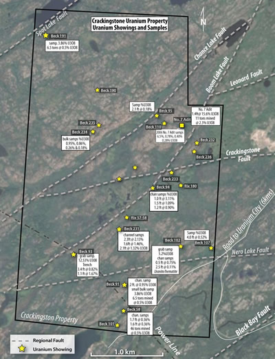
Black Bay Shear Zone which hosts several past producing uranium minesHistoric grab samples at uranium showings (%U3O8); Beck 93-12.53%; Beck 102-5.2% Beck 91 -2.86%
Belmont 2008 Drilling DH-C14 intercepted 2.09% U3O8 over 0.3 m and 0.87% U3O8 over 0.5 m within 1.18% U3O8 over 0.9 m from 49.1 to 50.0 m.Ground Spectrometer surveying outlined a radioactive zone 1km long and 300m wide with CPS readings ranging from 400-65,000 cps.
No less than 3 major conductive structural corridors associated with Uranium occurrences identified totaling 10 kms, with 2 areas of fault intersections being prime locations for uranium mineralization
We have produced a very informative video which does a great job in telling the Crackingstone visual story. We invite you to watch it athttps://belmontresources.com/crackingstone-video/”
Click Image To View Full Size
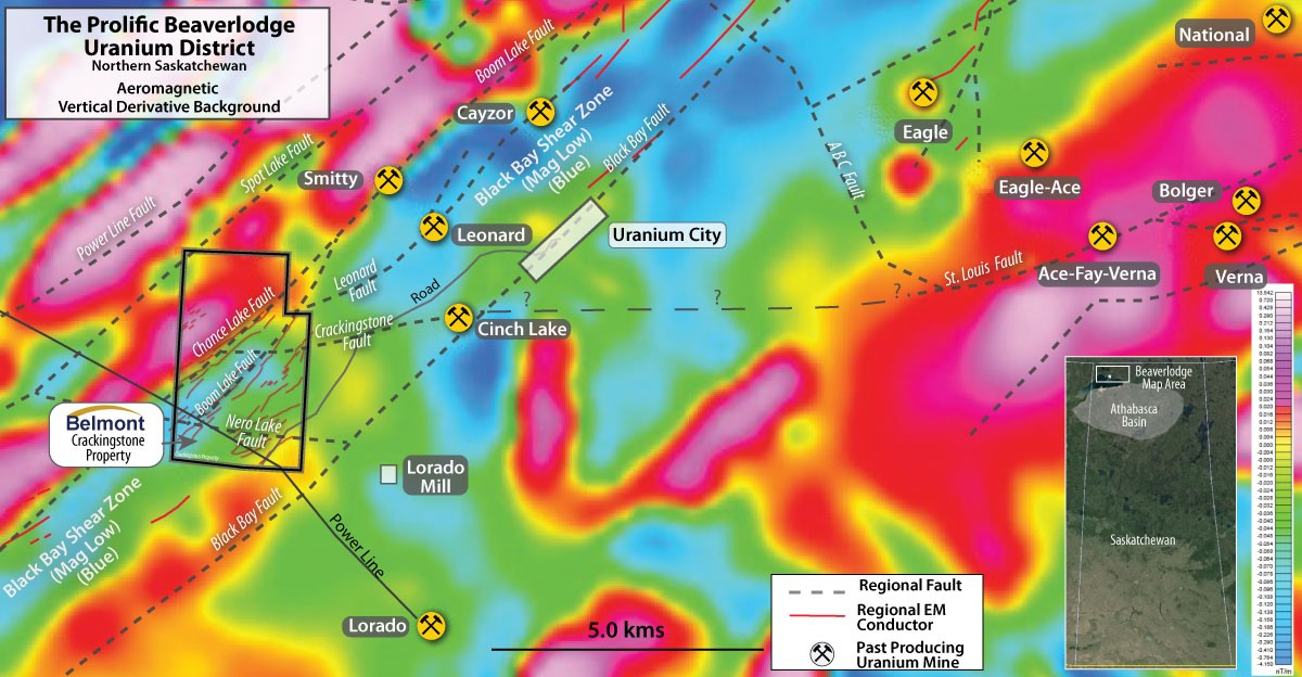
The 100% owned Crackingstone property is located in the
Historic work in the
The Crackingstone property covers 5 kms of the
Crackingstone Historic Exploration
In 1958 Mr.
E. Kull , drove a short adit which is now referred to as the Number 7 Adit, from the base of a trench, previously returned 15.6% U3O8 over 0.43m. He shipped 11 tons of broken rock to the Lorado mill which graded 2.3% U3O8.
In 1959 Uranium stain was visible at a few places near the Beck 91 showing. A channel sample assayed 0.61m at 0.95% U3O8 and a bulk sample from the same locality assayed 3.86% U3O8.
A grab sample containing considerable yellow stain, possibly fine disseminated pitchblende, from the Beck 93 showing, assayed 12.53% U3O8.
At the Beck 231 showing Channel sampling assayed 1.32% U3O8 over 0.64m, 2.13% over 0.70m and 1.46% over 0.49m.
At the Beck 102 showing a grab sample assayed 5.2% U3O8.
Structural Faults
On the property and on strike with the
These faults appear to have been reactivated several times to provide ample fractured ground for hosting the uranium mineralization. The easterly Crackingstone fault intersects the two northeasterly faults on the property.
The two areas of fault intersections are prime locations for potential uranium mineralization. The intersection area of the
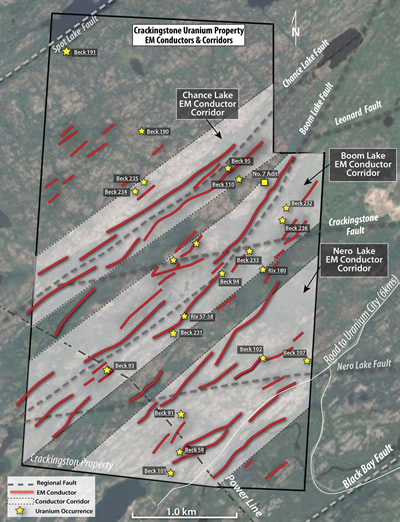
A 2007 EM survey by
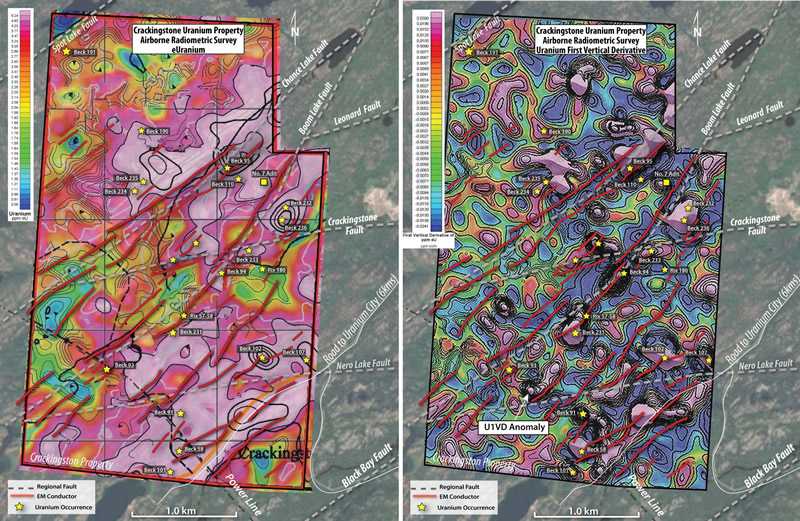
A 2007 Airborne Radiometric survey identified two large Uranium anomalies. The north anomaly is on a north easterly trend and appears to be associated with the northern portions of the
The south east Uranium anomaly trends north easterly as well, and appears to be associated with the
The Uranium radiometric data was filtered to produce a “Uranium First Vertical Derivative (U1VD)” map. The U1VD algorithm enhances the shallow sources of uranium by suppressing the effect of the deeper ones. This helps to reveal near-surface uranium mineralization on the property. Most all of the uranium occurrences on the property are coincident with a U1VD anomaly which adds confidence to use of U1VD mapping as a powerful resource in combination with the structural faults and EM conductive corridors for the selection of future drill targets.
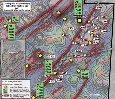
A ground radioactivity survey using a RS-125 Spectrometer, over the central area of the property was conducted in 2007. Readings were taken in areas of rock outcroppings and also at various uranium occurrences. Several high radioactive readings were recorded in this area with readings reaching >65,000 CPS which is considered to be “off-scale”.
A radioactive zone 1km long and 300m wide, with CPS readings ranging from 400-65,000 CPS was identified on the north easterly trending
2008 Drilling
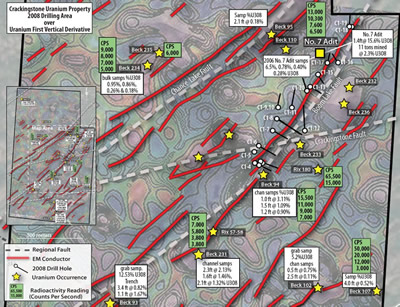
In March of 2008
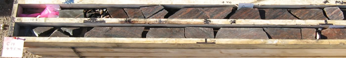
All of the drill core was mineralized with uranium.
Some highlights are as follows:
Hole C14:
2.087% U3O8 over 0.3 m and 0.873% U3O8 over 0.5 m
within 1.182% U3O8 over 0.9 m from 49.1 to 50.0 m
Hole C8:
0.362% U3O8 over 0.15 m from 114.4 to 114.55 metres
within 0.277% U3O8 over 0.25 m from 114.4 to 114.65 m
0.371% U3O8 over 0.5 m starting from 116.2 to 116.7 m;
0.146% U3O8 over 0.35 metres from 123.35 to 123.7 m
Hole C10:
0.256% U3O8 over 0.4 m from 108.5 to 108.9 m
In addition to the uranium mineralization, drilling intercepted a 1.8 kilometer pegmatite dyke. Pegmatite is often associated with uranium mineralization in the
The results of the 2008 drilling were very positive with the interception of uranium mineralization, pegmatites and hematite alteration along the
2024 Exploration
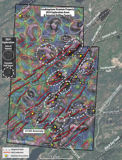
In preparation for a 2024 exploration program
on or near a major fault,
on or near an EM conductor
on or near a U1VD anomaly,
surface uranium occurrence.
Phase 1 of the 2024 exploration program which is expected in Q2 of 2024, will involve ground verification of the high priority targets and prioritizing selected drill targets for a Q4 drill program.
About
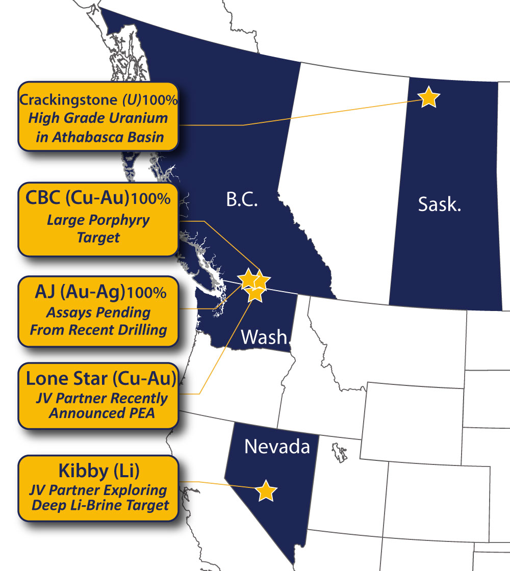
Athelstan-Jackpot (A-J):2 former gold mines. Initial 2023 drill results from Athelstan gold mine area drilling indicates peripheral alteration zone to a potential deep-seated gold-copper porphyry.
CrackingstoneUranium:High grade uranium property situated in the prolific
Beaverlodge Uranium District of theAthabasca basin. The Project covers 4 kilometers of theBlack Bay Shear Zone , a northeast trending magnetic low corridor which hosts 4 past producing mines.
Come By Chance (CBC):2021 geophysics delineated potential large copper-gold porphyry
2022 drilling provided further vectors towards potential core of porphyry;
The
Lone Star Copper-Gold:optioned to Australian Marquee Resources ASX:MQR; MQR has spent$2.5M in drilling, completed new resource inDec. 2022 and a PEA inNovember 2023 earning them a 50% interest in the property.
TheKibby Basin Lithiumproject located 60 kilometers north of the lithium rich
Clayton Valley Basin : Optioned 80% of the central Kibby Playa claim block to Australian Marquee Resources MQR. MQR has spent$2.5M in drilling in 2022 for potential deep seated lithium brine. 2022 Drilling confirmed high levels of lithium-bearing sediments along with dissolved lithium in the groundwater. Mineralized intervals containing up to 924 ppm lithium with greater than 300 ppm lithium over thicknesses in excess of 450m have been identified in core samples of clay-rich playa sediments.
Click Image To View Full Size
NI 43-101 Disclosure:
The technical and scientific information in this news release has been reviewed and approved by
ON BEHALF OF THE BOARD OF DIRECTORS
“George Sookochoff”
Neither the
This Press Release may contain forward-looking statements that may involve a number of risks and uncertainties, based on assumptions and judgments of management regarding future events or results that may prove to be inaccurate as a result of exploration and other risk factors beyond its control. Actual events or results could differ materially from the Companies forward-looking statements and expectations. These risks and uncertainties include, among other things, that we may not be able to obtain regulatory approval; that we may not be able to raise funds required, that conditions to closing may not be fulfilled and we may not be able to organize and carry out an exploration program in 2023, and other risks associated with being a mineral exploration and development company. These forward-looking statements are made as of the date of this news release and, except as required by applicable laws, the Company assumes no obligation to update these forward-looking statements, or to update the reasons why actual results differed from those projected in the forward-looking statements.
Details on the sources of information contained within this News Release:
Report No. 126; Uranium Deposits of the
A
A
An Interpretation of Aeroquest’s
Saskatchewan Mineral Deposit Index (SMDI) - digital information on all known mineral occurrences in the Province of
Copyright (c) 2024 TheNewswire - All rights reserved.
Copyright (c) 2024 TheNewswire - All rights reserved., source
