A total of nine lithium soil anomalies have been identified at Preissac-
- Athona Anomaly
- Key West Anomaly
- Narwhal Anomaly
- NW Buffalo Anomaly
- West BaMo Anomaly
- SE Preissac Anomaly
- NW Narwhal Anomaly
- South Key West Anomaly
- SW Narwhal Anomaly
Each anomaly consists of samples containing greater than 100 ppm lithium. Five of these anomalies (1-3 & 7-8) are located within the heart of the Vallée
The 2022 soil sampling property-wide survey was completed on 400 m x 200 m sample station spacings (608 samples). The 2023 soil sampling property-wide survey was completed on 200 m x 100 m sample station spacings (265 samples).
Detailed description of each anomaly
1. Athona Anomaly
The Athona Anomaly is comprised of five sub-subsections scattered over a 1,600 m long by 650m wide (see Figure 3). Lithium soil concentrations in the Athona Anomaly range from 165 ppm Li to 348 ppm Li. The sub-sections of the Athona Anomaly surround the New Athona Mo-Li Occurrence, which was discovered in 1960. Grab samples ranging up to 11.99% Mo and 0.28% Li2O have been reported at the New Athona Mo-Li Occurrence (see Government of
https://sigeom.mines.gouv.qc.ca/signet/classes/I1103_index?format=COMPLET&type_reqt=U&mode=NOUVELLE&l=F&entt=GM&numr_utls=174579064607&alias_table_crit=F4E02&mnen_crit=NUMR_INTER&oper_crit=EGAL&valr_crit=5431
The Athona Anomaly is located 2.1 km west of the eastern property boundary and is along strike of the Keyboycon Lithium Showing on the adjacent property (see Figure 3). Only one historical drill hole is present between the Athona Anomaly and the Keyboycon Lithium Showing.
Seven short holes have been drilled at the New Athona Mo-Li Occurrence. While each hole contained anomalous molybdenum, none of the holes were sampled for lithium (see Government of
https://sigeom.mines.gouv.qc.ca/signet/classes/I1103_index?l=f&type_reqt=U&entt=LG&mode=NOUVELLE&format=RESUME&alias_table_crit=EXADOC&mnen_crit=NUMR_RAPR&oper_crit=EGAL&valr_crit=GM%2017912
2. Key West Anomaly
The Key West Anomaly is 1,400 m long and up to 200 m wide and is defined by eight anomalous samples ranging from 157 ppm Li to 248 ppm Li. The anomaly is located 1,600 m west of the property boundary and is underlain by metasedimentary rocks located less than 200 m north of the LaCorne Batholith margin, the same stratigraphic and structural location of the nearby Canada Lithium/Beluga lithium occurrence on the adjacent property (see Figure 3).
3. Narwhal Anomaly
The Narwal Anomaly is 800 m long and up to 150 m wide extending westward from the eastern property boundary. The anomaly is located immediately along strike of lithium-bearing pegmatites discovered on the adjacent property (see Figure 3). The Narwhal Anomaly has never been tested with a drill hole. The anomaly consists of two samples, one of which returned 180 ppm Li and the other 260 ppm Li.
4. NW Buffalo Anomaly
The NW Buffalo Anomaly returned a sample at 158 ppm Li and is located on the west side of the property, 400 m west of the Buffalo Canadian-
5. West BaMo Anomaly
The West BaMo Anomaly consists of single sample containing 243 ppm Li and is located 400 m west of the known Baillargé Molybdènum Occurrence. No known historical drilling has been completed in the West BaMo Anomaly Area according to the Government of Quebec SIGEOM website.
6. SE Preissac Anomaly
The SE Preissac Anomaly is 136 ppm Li and is located on the southeast corner of the property. No known historical drilling has been completed in the SE Preissac Anomaly Area according to the Government of Quebec SIGEOM website.
Given that the anomalies (4-6) occur within the 400 m x 200 m soil sample survey area, additional soil sampling, prospecting, and geological mapping is warranted in the vicinity of these three showings and will be undertaken in future exploration programs.
7. NW Narwhal Anomaly
The NW Narwhal Anomaly is a single sample anomaly of 157 ppm Li located 650 m northwest of the Narwhal Anomaly within the Vallée Lithium Trend. No known historical drilling has been completed in the area according to the Government of Quebec SIGEOM website.
8. South Key West Anomaly
The South Key West Anomaly is a single sample anomaly of 138 ppm Li located 100 m south of the Key West Anomaly within the Vallée Lithium Trend. No known historical drilling has been completed in the area according to the Government of Quebec SIGEOM website.
9. SW Narwhal Anomaly
The SW Narwhal Anomaly is a single sample anomaly of 122 ppm Li located 1,200 m southwest of the Narwhal Anomaly, south of the Vallée Lithium Trend. No known historical drilling has been completed in the area according to the Government of Quebec SIGEOM website.
Upcoming 2024 Exploration Program
The northeast area of the
The Company intends to follow-up the lithium soil anomalies at
Exploration Program Specifics
About Soil Sampling
Soil samples were collected from the B-horizon of the soil profile in plastic bags shipping to the laboratory for geochemical analysis. The analyses were undertaken by
The Company implemented a QA/QC procedures to ensure the validity of the sampling by using a series of field duplicates and reference standards in each batch of samples sent for analysis. A review of the field duplicates and reference standards indicate that the soil sample results are likely reasonably precise and accurate.
Qualified Person
The scientific and technical information contained herein has been reviewed and approved by
About
For more information:
Email | info@consolidatedlithium.com
Phone | (306) 713-1401
Website |www.consolidatedlithium.com
Cautionary Statements
The content and grades of any mineral deposits at the Company’s properties are conceptual in nature. There has been insufficient exploration to define a mineral resource on its properties and it is uncertain if further exploration will result in any target being delineated as a mineral resource. In addition, sample results at or around, and information applicable to, New Athona, the North American Lithium or
This press release contains “forward‑looking information” within the meaning of applicable Canadian securities legislation. Forward‑looking information includes, but is not limited to, statements with respect to the scope, objectives, and expected results of the Company’s summer 2023 exploration program and the Company’s ability to execute its business plan. Generally, forward‑looking information can be identified by the use of forward-looking terminology such as “plans”, “expects” or “does not expect”, “is expected”, “budget”, “scheduled”, “estimates”, “forecasts”, “intends”, “anticipates” or “does not anticipate”, or “believes”, or variations of such words and phrases or statements that certain actions, events or results “may”, “could”, “would”, “might” or “will be taken”, “occur” or “be achieved”. Forward‑looking information is subject to known and unknown risks, uncertainties and other factors that may cause the actual results, level of activity, performance or achievements of CLM to be materially different from those expressed or implied by such forward‑looking information, including but not limited to: receipt of necessary approvals; general business, economic, competitive, political and social uncertainties; future mineral prices and market demand; accidents, labour disputes and shortages and other risks of the mining industry. Although CLM has attempted to identify important factors that could cause actual results to differ materially from those contained in forward-looking information, there may be other factors that cause results not to be as anticipated, estimated or intended. There can be no assurance that such information will prove to be accurate, as actual results and future events could differ materially from those anticipated in such statements. Accordingly, readers should not place undue reliance on forward‑looking information. CLM does not undertake to update any forward-looking information, except in accordance with applicable securities laws.
NEITHER TSX VENTURE EXCHANGE NOR ITS REGULATION SERVICES PROVIDER (AS THAT TERM IS DEFINED IN THE POLICIES OF THE
Appendix

Figure 1 - CLM Regional Projects Map - Property boundaries from Company resources and historical drill hole, geology and showing information from the Government of
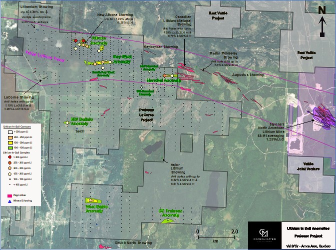
Figure 2 - Lithium-in-soil anomalies defined by the 2022 and 2023 property-wide soil sampling program at the
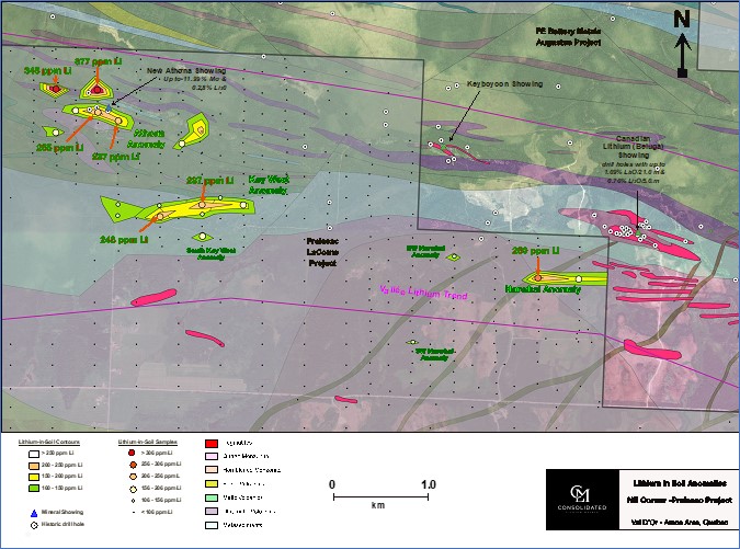
Figure 3 - Lithium-in-soil results from the Northeast area of the Preissac-LaCorne Property
Photos accompanying this announcement are available at
https://www.globenewswire.com/NewsRoom/AttachmentNg/3e4ef5d1-f885-49b0-a5b6-c137a66ebcf1
https://www.globenewswire.com/NewsRoom/AttachmentNg/d173b7fe-7918-4a8d-98bd-90230feb74dd
https://www.globenewswire.com/NewsRoom/AttachmentNg/0507e279-4362-4763-b202-36188509065c

![]()
Figure 1
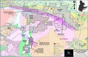
CLM Regional Projects Map - Property boundaries from Company resources and historical drill hole, geology and showing information from the Government of Quebec website
Figure 2

Lithium-in-soil anomalies defined by the 2022 and 2023 property-wide soil sampling program at the Preissac-LaCorne Project
Figure 3
Lithium-in-soil results from the Northeast area of the Preissac-LaCorne Property
2024 GlobeNewswire, Inc., source
