Highlights
- Hole TS21-001 intersected 10.41% zinc, 11.58% lead, and 149.9 g/t silver over 7.99 m (true width 2.46 m) within a broader interval of 6.92% zinc, 5.03% lead, and 48.7 g/t silver over 37.99 m (11.70 m true width).
Tom East is the highest-grade deposit on the property and remains open for expansion.- Assay results from the last two holes at Boundary West are pending.
Table 1: Drill Results,
| Hole | From | To | Intersected width | Estimated True width | Zinc | Lead | Silver | Bulk density |
| (meters) | (meters) | (meters) | (meters) | (%) | (%) | (g/t) | (t/m3) | |
| TS21-001 | 145.21 | 183.20 | 37.99 | 11.70 | 6.92 | 5.03 | 48.7 | 3.200 |
| Including | 145.21 | 153.20 | 7.99 | 2.46 | 10.41 | 11.58 | 149.9 | 3.453 |
| Including | 150.20 | 152.20 | 2.00 | 0.62 | 12.61 | 15.01 | 219.6 | 4.271 |
| Including | 151.20 | 152.20 | 1.00 | 0.31 | 18.34 | 16.68 | 256.9 | 4.118 |
CEO Statement
Tom East Drilling Results
Hole TS21-001 was drilled at Tom East, a high-grade zone within the Tom deposits area (Maps 1 and 2).
Photo 1: Hole TS21-001 at 148.53-148.73 m illustrating laminated high-grade mineralization is available at https://www.globenewswire.com/NewsRoom/AttachmentNg/92701a3f-7ce2-43e4-b943-7e797eaba6a3
The mineralization comprises laminated to massive sulphides, predominantly consisting of thinly laminated sphalerite, galena, barite, and chert. Soft-sediment deformation has created chaotic laminae (Photo 1) further distorted by regional folding. Mineralization is consistent with other intervals encountered within the Tom East and
Notes on sampling, assaying, and data aggregation:
The diamond drill core logging and sampling program was carried out under a rigorous quality assurance / quality control program using industry best practices. Drill intersections in this release are all HQ3 (split tube) size core (61.1mm / 2.4-inch diameter) with recoveries typically above 85% unless otherwise noted in the table of results. After drilling, core was logged for geology, structure, and geotechnical characteristics, then marked for sampling and photographed on site. The cores for analyses were marked for sampling based on geological intervals with individual samples 1.5 m or less in length. Drill core was cut lengthwise in half with a core saw; half-core was sent for assays reported in this news release, and the other half is stored on site for reference. Bulk density was determined on site for the entire length of each sample assayed by measurement of mass in air and mass in water. Sample duplicate bulk density determinations and in-house bulk density standard determinations were each made at a rate of 5%. Since 2017, four in-house bulk density standards (mineralized drill core from the Tom deposit that span a range of densities) have been used and show an acceptable long-term precision. Certified standard masses are used to calibrate the scale balance used for bulk density determinations.
A total of 5% assay standards or blanks and 5% core duplicates are included in the sample stream as a quality control measure and are reviewed after analyses are received. Standards and blanks in 2021 drill results to date have been approved as acceptable. Duplicate data add to the long-term estimates of precision for assay data on the project and precision for drill results reported is deemed to be within acceptable levels. Samples were sent to the Bureau Veritas preparation laboratory in
Results in this news release are length and bulk-density weighted averages as would be used in a Mineral Resource estimate. Readers are cautioned that in Fireweed news releases prior to 2020, only length weighted assay averages were reported which may result in slightly lower (under-reported) average values. Length and bulk-density weighted averages have been reported as these most accurately represent the average metal-content of the intersections.
Qualified Person Statement
Technical information in this news release has been approved by
About
In
Additional information about
ON BEHALF OF FIREWEED ZINC LTD.
“
CEO & Director
Contact:
Phone: (604) 646-8361
Neither the
Cautionary Statements
This news release may contain “forward-looking” statements and information relating to the Company and the
Map 1: Location of Macmillan Pass deposits and exploration targets is available at https://www.globenewswire.com/NewsRoom/AttachmentNg/9f2d7726-5569-4797-9385-9624a812402c
Map 2: Location of
Table 2: 2021 drill hole results and observations
| Drill Hole | Length (m) | Zone | Target | Results and Observations |
| NB21-001 | 277.0 | Boundary West | BZW down-dip extension | Results reported 17th |
| NB21-002 | 439.0 | Boundary West | BZW down-dip extension | Results reported 16th |
| NB21-003 | 189.0 | Boundary West | BZW step-out to west | Results reported 23rd |
| NB21-004 | 382.7 | Boundary West | BZW step-out to west | Results reported 23rd |
| TS21-001 | 402.7 | Results reported in this release. | ||
| TS21-002 | 46.0 | Hole ended early due to drilling problems and redrilled as TS21-003. | ||
| TS21-003 | 401.5 | No mineralization encountered. | ||
| NB21-005 | 481.7 | Boundary Main | BZ down-dip extension | Results reported 18th |
| NB21-006 | 157.2 | Boundary West | BZW step-out to east | Results reported 23rd |
| NB21-007 | 106.7 | Boundary West | BZW step-out to east | Results reported 23rd |
| NB21-008 | 325.8 | Boundary West | BZW step-out to east | Results reported 23rd |
| NB21-009 | 445.6 | Boundary West | BZW down-dip extension | Wide zone encountered. Assays pending. |
| NB21-010 | 190.5 | Boundary Main | BZ step-out to west | Moderate zone encountered. Assays pending. |
Table 3: 2021 drill collar details
| Drill Hole | Length (m) | Zone | Easting* | Northing* | Elevation (m) | Dip (°) | Grid Azimuth (°) |
| NB21-001 | 277.0 | Boundary West | 422052 | 7010614 | 1217 | -65 | 211 |
| NB21-002 | 439.0 | Boundary West | 422053 | 7010614 | 1218 | -75 | 212 |
| NB21-003 | 189.0 | Boundary West | 421932 | 7010644 | 1226 | -50 | 204 |
| NB21-004 | 382.7 | Boundary West | 421932 | 7010644 | 1226 | -75 | 204 |
| TS21-001 | 402.7 | 442064 | 7004322 | 1679 | -82 | 060 | |
| TS21-002 | 46.0 | 442197 | 7004428 | 1688 | -89 | 236 | |
| TS21-003 | 401.5 | 442197 | 7004431 | 1688 | -89 | 236 | |
| NB21-005 | 481.7 | Boundary Main | 422397 | 7010550 | 1203 | -75 | 211 |
| NB21-006 | 157.2 | Boundary West | 422093 | 7010516 | 1189 | -50 | 211 |
| NB21-007 | 106.7 | Boundary West | 422094 | 7010518 | 1189 | -70 | 211 |
| NB21-008 | 325.8 | Boundary West | 422094 | 7010518 | 1189 | -75 | 211 |
| NB21-009 | 445.6 | Boundary West | 422128 | 7010632 | 1223 | -68 | 211 |
| NB21-010 | 190.5 | Boundary Main | 422199 | 7010400 | 1159 | -75 | 211 |
*

![]()
Photo 1: Hole TS21-001 at 148.53-148.73 m illustrating laminated high-grade mineralization.
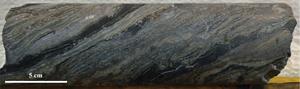
Photo 1: Hole TS21-001 at 148.53-148.73 m illustrating laminated high-grade mineralization.
Macmillan Pass 2021 Exploration Targets
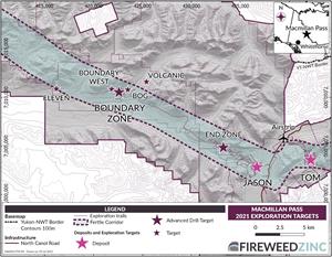
Map 1: Location of Macmillan Pass deposits and exploration targets.
Tom East 2021 Drilling
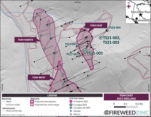
Map 2: Location of Tom East drill hole TS21-001, for results reported in the release.
2022 GlobeNewswire, Inc., source

