Highlights from the Soil Sampling program
- 8.8 km x 1.5 km NE-SW trending coherent copper (“Cu”) anomaly (>150ppm) linking two zones of shallow (<298m) high-grade historical drilling that sit 5 km apart and include re-assayed results of 108m @ 0.94% CuEq (including 30.8m @ 2.21% CuEq), and 132.6m @ 0.80% CuEq (including 57.1m @ 1.00% CuEq) starting from surface.
- “Bull’s eye” 2.8 km x 1.6 km coherent Molybdenum (“Mo”) anomaly interpreted to be the core of an at surface porphyry system that is untested with drilling.
- An Arsenic (“As”) peripheral to copper-molybdenum anomaly thought to be associated with an intermediate-sulphidation epithermal system which recent sampling by Arras has returned gold and silver grades up to 29g/t Au & 287g/t Ag.
- Results confirm a multi-kilometer-scale system, delimited by several mineralized zones which may be contiguous under surface cover.
- Arras collected 31,000 soil samples over the Elemes Licence in 2023. The results presented in this news release cover only the western half of the Elemes Licence and represent approximately 60% of the soil samples collected. The results of the remaining 14,000 soil samples are expected in the next 3 to 4 weeks.
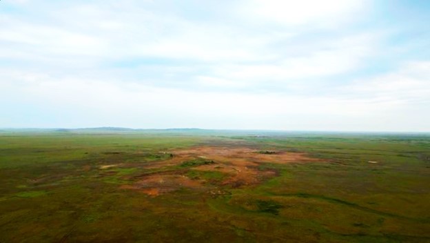
Figure 1. Drone photo showing outcropping argillic alteration at Berezski Central target (Elemes Licence)

Figure 2. The 8.8 km copper soil anomaly identified by Arras within the Elemes Licence. Also shown are the results of the re-assayed historical drillholes located at Quartzite-Gorka and Berezski East announced by Arras on
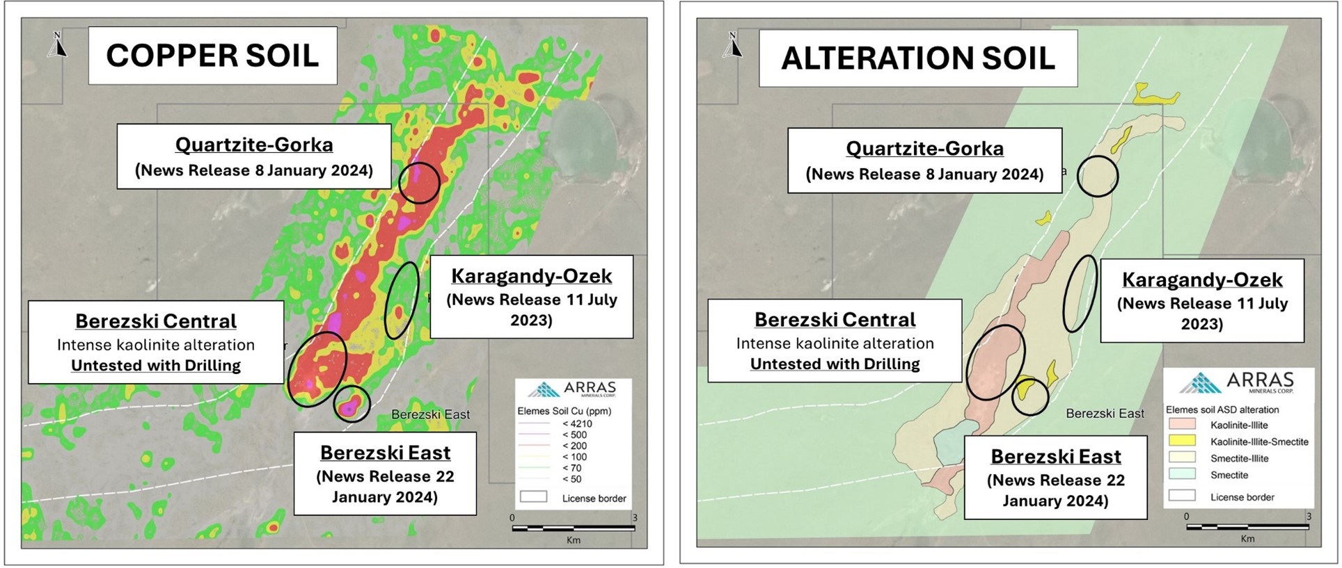
Figure 3. Soil anomaly maps showing copper results and the alteration map. Also shown are the locations of the re-assayed drillholes located at Quartzite-Gorka and Berezski East as well as Karagandy-Ozek, a high-grade gold-silver epithermal zone. The intensely altered Berezski Central zone is also shown which is co-incident with the 2.8 kilometer x 1.6 kilometer molybdenum soil anomaly (see figure 4).
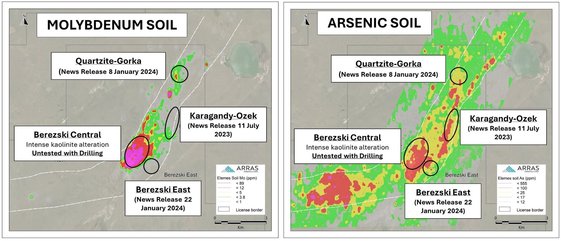
Figure 4. Soil anomaly maps showing molybdenum, and arsenic results. Also shown are the locations of the re-assayed drillholes located at Quartzite-Gorka and Berezski East as well as Karagandy-Ozek, a high-grade gold-silver epithermal zone. The intensely altered Berezski Central zone is also shown which is co-incident with the 2.8 kilometer x 1.6 kilometer molybdenum soil anomaly.
The Soil Sampling Program: In 2023, a comprehensive soil sampling program was undertaken across the Elemes Licence area. This program specifically targeted the well-developed "B soil horizon" utilizing a 50-meter sample interval and 200-meter line spacing grid. A total of approximately 31,000 samples were collected.
This press release announces the findings from the initial batch of 17,000 samples, which cover an area of 189.3 sq. km (approximately 11.5 km by 18.2 km) situated on the western side of the Elemes Licence. The results from the remaining 14,000 samples, covering the eastern portion of the Elemes Licence, are anticipated to be available within the next 3 to 4 weeks.
The soil analysis was conducted utilizing a Portable X-ray fluorescence device ("pXRF"), a widely employed instrument for determining the elemental composition of samples. Due to the limited sampling area of the pXRF, the results presented in this release are considered "indicative" rather than fully quantitative regarding mineralization.
Despite this limitation, the results have revealed a substantial and coherent copper-in-soil anomaly, with copper concentrations exceeding 150 ppm. Background copper in the area is considered to be less than 20 ppm. This anomaly stretches over a remarkable distance of more than 8.8 km from north to south and extends to approximately 1.5 km in width from east to west. Notably, it connects the Quartzite_Gorka and Berezski East historical drilling areas, which are situated over 5 km apart. These areas have previously confirmed high-grade porphyry copper-gold mineralization starting at the surface.
The continuity of the copper soil anomaly strongly suggests that the Quartzite-Gorka and Berezski-East areas represent only a small part of a much larger porphyry copper-gold system.
Re-Assay of Historical Core: The Quartzite-Gorka and Berezski East areas were drilled between 2007 and 2010. All available drill-core have been re-logged in detail by Arras for lithology, structure, alteration, and mineralization. The mineralization seen at both locations is interpreted to be the upper part of a porphyry copper-gold mineralizing system. The mineralization comprises of sheeted and/or stockwork veining of quartz-magnetite “A” veins with minor chalcopyrite-bornite ± k-feldspar halos; magnetite-only “M” veins; and quartz-chalcopyrite veins. Locally disseminated patches of chalcopyrite, bornite and pyrite occur. Anhydrite veins and late epidote-carbonate veins are also observed. The host diorite intrusion is fine-grained, equigranular and typically highly magnetic. Strong potassic (k-feldspar-quartz-magnetite-secondary biotite) alteration of the host diorite has been variably overprinted by intermediate argillic (illite-chlorite) alteration.
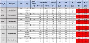
Arras also sent 6 holes, three each from Quartzite-Gorka and Berezski-East for re-assay. The summarized results of these re-assays are provided in Table 1 below and were disclosed in news releases on
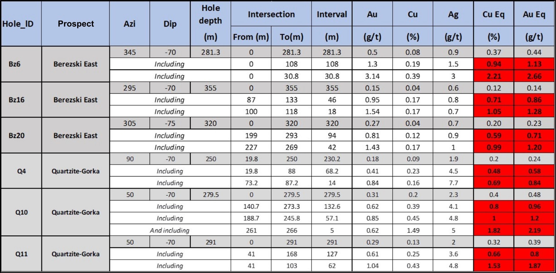
Table 1. Summary table for the re-assay of historical drill holes for Quartzite-Gorka and Berezski-East
Notes: Copper Equivalent (“CuEq”) grades reported for the drill holes at Quartzite Gorka were calculated using the following formula: CuEq % = Copper (%) + (Gold (g/t) x 0.8264) + (Silver (g/t) x 0.0107) + (Molybdenum (ppm) x 6.0000). Gold Equivalent (“AuEq”) grades reported for the drill holes at Quartzite Gorka were calculated using the following formula: AuEq g/t = Gold (g/t) + (Copper (%) x 1.2100) + (Silver (g/t) x 0.0129) + (Molybdenum (ppm) x 4.0334). Assumptions used for the copper and gold equivalent calculations were metal prices of
The Berezski Target: is located within the 425 square km Elemes mineral exploration licence. The Licence benefits from excellent modern infrastructure and ease of accessibility, being located only 20 km from Arras’ operational base in the city of Ekibastuz, northeastern
The Berezski target is located within the Bozshakol-Chingiz metallogenic belt that also hosts the Beskauga porphyry copper-gold-silver project approximately 80 km to the east, and KAZ Minerals’ Bozshakol porphyry copper-gold mine (www.kazminerals.com) approximately 60 km to the northwest.
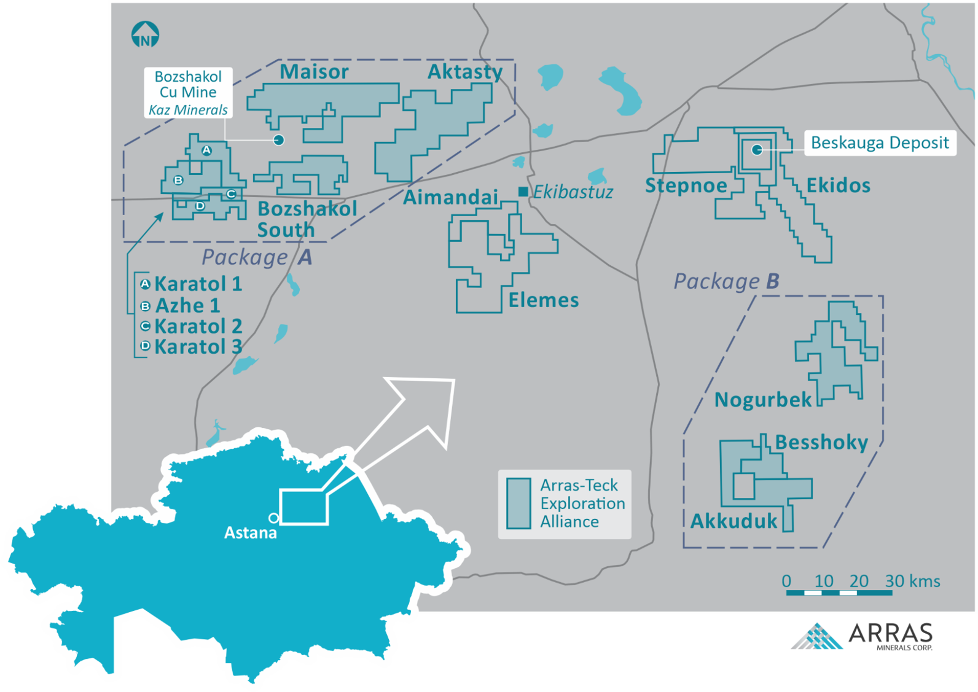
Figure 5. Arras’s License Package showing Arras-Teck Strategic Alliance Areas as “Package A” and “Package B” as well as the Elemes, Aimandai, Stepnoe, & Ekidos licences which are 100% owned by Arras.
Sampling Methodology
Samples were collected on a 50m (East-west) by 200m (north-south) grid spacings. Samples were collected from hand-dug pits, trying to consistently sample the B horizon. Approximately 500 grams of material was collected and sieved (5mm mesh size) to review larger particles and organic matter. Following collection, the samples were bagged, dried, and analyzed by the company with a Portable Niton XL5 X-ray fluorescence analyzer at the company’s core storage facility in Ekibastuz.
Assay, QAQC Procedures:
Analysis was conducted using the company’s two Niton XL5 portable XRF units. Units were calibrated at the start and end of each work shift as well as after every 100 samples to verify accuracy. In addition, a measurement from a certified reference material was taken every 20 measurements to ensure accuracy and repeatability of data. In addition, prior to commencement of the measurements, 100 duplicate samples were analyzed using both units to confirm that both units were producing accurate results and that no bias was present in either of the units.
All soil material is stored at Arras’ warehouse in Ekibastuz, and the company plans to send a proportion of these samples to
Qualified Person: The scientific and technical disclosure for the
On behalf of the Board of Directors
"Tim Barry"
Chief Executive Officer and Director
INVESTOR RELATIONS:
+1 604 687 5800
info@arrasminerals.com
Further information can be found on the Company’s website https://www.arrasminerals.com or follow us on LinkedIn: https://www.linkedin.com/company/arrasminerals or on X, formerly known as Twitter: https://twitter.com/arrasminerals
About
Arras is a Canadian exploration and development company advancing a portfolio of copper and gold assets in northeastern
Cautionary Note to U.S. Investors concerning estimates of Measured, Indicated, and Inferred Resources: This press release uses the terms “measured resources”, “indicated resources”, and “inferred resources” which are defined in, and required to be disclosed by, NI 43-101. The Company advises U.S. investors that these terms are not recognized by the
Disclosure of “contained ounces” in a resource is permitted disclosure under Canadian regulations, however the
Cautionary note regarding forward-looking statements: This news release contains forward-looking statements regarding future events and Arras’ future results that are subject to the safe harbors created under the
Images accompanying this announcement are available at
https://www.globenewswire.com/NewsRoom/AttachmentNg/8c450f63-f326-4ad3-8d8f-413b85fcdd9a
https://www.globenewswire.com/NewsRoom/AttachmentNg/9294db4f-21a1-4206-a544-23eac20dcc2b
https://www.globenewswire.com/NewsRoom/AttachmentNg/7153df83-e825-4ed3-8157-eec2e8408cb2
https://www.globenewswire.com/NewsRoom/AttachmentNg/8196924f-1022-4e64-ad45-d6896647bc6f
https://www.globenewswire.com/NewsRoom/AttachmentNg/6fa34fde-af3a-4e8c-8aa7-70c4da318f89
https://www.globenewswire.com/NewsRoom/AttachmentNg/4c764bcc-42c4-4bee-8d7c-3a0023e25d33

![]()
Figure 1
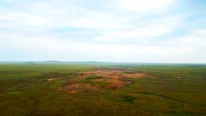
Drone photo showing outcropping argillic alteration at Berezski Central target (Elemes Licence)
Figure 2
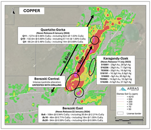
The 8.8 km copper soil anomaly identified by Arras within the Elemes Licence. Also shown are the results of the re-assayed historical drillholes located at Quartzite-Gorka and Berezski East announced by Arras on 8 January 2024 , and 22 January 2024 respectively. The location of the medium sulphidation epithermal system sampled by Arras and announced on 11 July 2023 is also shown. Lastly a wide zone of intense kaolinite alteration at Berezski Central is also shown that is co-incident with the strong molybdenum anomaly that has been identified and shown in Figure 4.
Figure 3
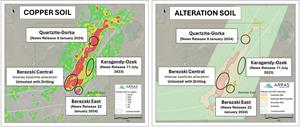
Soil anomaly maps showing copper results and the alteration map. Also shown are the locations of the re-assayed drillholes located at Quartzite-Gorka and Berezski East as well as Karagandy-Ozek, a high-grade gold-silver epithermal zone. The intensely altered Berezski Central zone is also shown which is co-incident with the 2.8 kilometer x 1.6 kilometer molybdenum soil anomaly (see figure 4).
Figure 4

Figure 4. Soil anomaly maps showing molybdenum, and arsenic results. Also shown are the locations of the re-assayed drillholes located at Quartzite-Gorka and Berezski East as well as Karagandy-Ozek, a high-grade gold-silver epithermal zone. The intensely altered Berezski Central zone is also shown which is co-incident with the 2.8 kilometer x 1.6 kilometer molybdenum soil anomaly.
Table 1
Summary table for the re-assay of historical drill holes for Quartzite-Gorka and Berezski-East
Figure 5
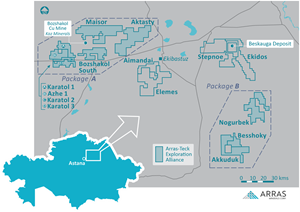
Arras’s License Package showing Arras-Teck Strategic Alliance Areas as “Package A” and “Package B” as well as the Elemes, Aimandai, Stepnoe, & Ekidos licences which are 100% owned by Arras.
2024 GlobeNewswire, Inc., source


