- Gonalbert is underlain by a dacitic intrusive dome approximately 1,300m by 600m which hosts epithermal Ag-Pb-Zn mineralization along structures that are exposed in a number of historical and recent artisanal workings and trenches.
- An IP chargeability anomaly surrounding the structures covers an area of 800m by 500m and extends to a depth of at least 400m, the depth limit of the survey.
- The chargeability anomaly becomes stronger, especially at depths greater than 100m, below a depleted, near-surface zone where sulphide mineralization has been extensively oxidized.
- Drilling to test this anomaly will commence shortly.
Geologically, the property is underlain by Ordovician sedimentary rocks that have been intruded by a Miocene dacitic dome which includes tuffs, breccias and intrusive dacite. The intrusion, which is approximately 1,300m by 600m wide (Figure 2), hosts epithermal Ag-Pb-Zn mineralization along structures cutting this intrusion. Until recently, an artisanal mining operation was active near the intersection of two major faults, with a small plant processing approximately 20 t/day. The head grade was reported to be around 180 g/t Ag, yielding a concentrate of about 1300 g/t Ag (Micon, 2023). Several other historic and more recent artisanal workings on the property are shown in Figure 2. Geological mapping, sampling, and trenching are being carried out on these artisanal working areas and other surface showings – assay results from this work are pending.
Magnetic and Induced Polarization survey data provide the first exploration information to a depth of approximately four hundred meters below where mineralization has been known since colonial times. Previous exploration was limited to surface trenches and artisanal workings. The magnetic map for the property shows that magnetic susceptibility is enhanced near a pair of northwest and north-northwest trending faults that intersect where artisanal mining has occurred for silver, lead and zinc. This close association of the magnetic mineralization with the intersecting faults is defined more clearly on the Analytical Signal (ASIG) map (Figure 3). Micon’s report refers to pyrrhotite in association with the “argentite, galena and zincblende” mineralization so these early results suggest that the magnetic survey may be able to detect the fault-controlled sulphide mineralization directly.
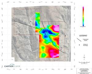
An Induced Polarization and Resistivity survey was carried out on seven lines in the central part of the Gonalbert concession using a conventional N=8 x 50m pole-dipole array followed by N=4 offset 100m dipoles to obtain chargeability and resistivity data to a depth approaching four hundred meters. Resistivity data (Figure 4) show distinct lows that coincide with the faults interpreted from the magnetic data and rugged topography.
An IP chargeability anomaly surrounding the structures covers an area of 800m by 500m and extends to a depth of at least 400m, the depth limit of the survey. Chargeable mineralization coincides with the enhanced conductivity along both fault traces as shown in Figure 5. The chargeability becomes stronger at depths greater than 100m, below a depleted, near-surface zone where sulphide mineralization has been extensively oxidized.
Qualified Person
Dr.
The Gonalbert property was surveyed magnetically by MES Geophysics personnel using GEM-19W GPS-guided magnetometers in walking mode on lines spaced 50m apart to achieve high resolution. On the east and west sides of the property the rugged topography was deemed unsafe for a ground-based Induced Polarization/Resistivity survey (IP/Res) in the first program. The IP/Res survey by MES Geophysics will be extended to cover the northwest part of the property.
About
Cartier Silver is an exploration and development Company focused on discovering and developing its recently acquired silver property assets, including the optioned
For further information please visit Cartier Silver’s website at www.cartiersilvercorp.com
| For further information please contact: | ||
| Thomas G. Larsen | Jorge Estepa | |
| Chief Executive Officer | Vice-President | |
| (800) 360-8006 | (800) 360-8006 | |
| (416) 360-8006 | (416) 360-8006 | |
The CSE has not reviewed nor accepts responsibility for the adequacy or accuracy of this release.
Statements in this release that are not historical facts are “forward-looking statements” and readers are cautioned that any such statements are not guarantees of future performance, and that actual developments or results, may vary materially from those in these “forward-looking statements”.
Figure 1: Location Map of
Figure 2: Geological Plan Map of Gonalbert Property
Figure 3: Magnetic Analytical Signal Map, Gonalbert Property
Figure 4: Resistivity Plan Map at N=4, Elevation 100m Below Surface, Gonalbert Property
Figure 5: Chargeability Plan Map at N=4, Elevation 100m Below Surface, Gonalbert Property
Photos accompanying this announcement are available at
https://www.globenewswire.com/NewsRoom/AttachmentNg/b4f156f5-a7cb-451b-9c9b-6019961ba779
https://www.globenewswire.com/NewsRoom/AttachmentNg/d6604ea5-7b8c-490f-845f-e35091dd7f8d
https://www.globenewswire.com/NewsRoom/AttachmentNg/f27d8e95-cc53-4fee-b89c-f504a18157a7
https://www.globenewswire.com/NewsRoom/AttachmentNg/a437ca6b-e5d0-4160-9f15-f5941e2c60e0
https://www.globenewswire.com/NewsRoom/AttachmentNg/18d12423-c697-41af-bb35-a7d5492038e8

![]()
Figure 1

Location Map of Gonalbert and Felicidad Properties , Las Chorrillos Project , Potosi Department , Southern Bolivia
Figure 2
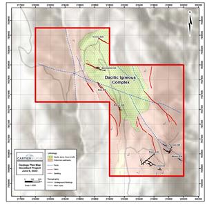
Geological Plan Map of Gonalbert Property
Figure 3
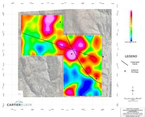
Magnetic Analytical Signal Map, Gonalbert Property
Figure 4
Resistivity Plan Map at N=4, Elevation 100m Below Surface, Gonalbert Property
Figure 5

Chargeability Plan Map at N=4, Elevation 100m Below Surface, Gonalbert Property
2023 GlobeNewswire, Inc., source