TORONTO, March 27, 2024 (GLOBE NEWSWIRE) -- Xanadu Mines Ltd (ASX: XAM, TSX: XAM) (Xanadu or the Company) is pleased to advise an initial 5,000m diamond drilling programme to test five main target areas at the highly prospective 100% owned Red Mountain copper and gold Project in the South Gobi region of Mongolia is now underway, with drilling expected to be completed by mid-May, and all assays available by end-June.
Highlights
- Exploration drilling focused on discovery of shallow high-grade gold and copper-gold deposit, akin to the shallower parts of the Northparkes copper gold porphyry deposits in NSW, Australia .
- Systematic diamond drilling program designed to test five high-priority targets, following up on more recent trenching and previous drilling; compelling results from the latter are highlighted, below:
- First results from the drilling program are anticipated late April.
Xanadu’s Executive Chairman and Managing Director, Mr Colin Moorhead, said,
“Drilling has commenced at our 100% owned Red Mountain copper and gold project with an initial 5,000m diamond hole programme targeting five of our highest priority targets. Red Mountain offers a rare opportunity to access a large, under-explored mineral district. We are conducting a systematic exploration program, including diamond drilling, that we expect will provide a new perspective on the mineral potential of the Red Mountain district. Xanadu is entering an exciting period of new opportunities for discovery and growth.”
Exploration Program Design
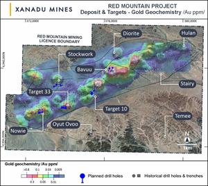
Five thousand meters of drilling has been designed to test five shallow high-grade gold and copper-gold targets across the Red Mountain Lease (Figures 1 and 2). Drilling is targeting:
- Shallow gold at Target 33,
- High-grade copper sulphide lodes at Target 10, and
- Shallow porphyry targets at Nowie, Stockwork and Bavuu (Figure 3).
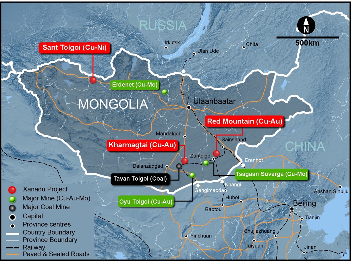
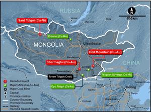
Figure 1: Map of Mongolia, showing location of the Red Mountain Mining Lease.

Figure 2: The Red Mountain Mining Lease with designed drill holes and target locations.
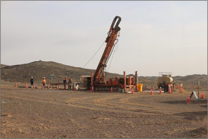
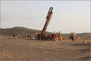
Figure 3: Exploration drilling has commenced at Red Mountain.
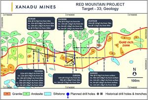
Target 33 – Shallow Epithermal Gold Mineralisation
Target 33 is a 1,000-metre-long and 100-wide-zone of alteration and anomalous gold mineralisation associated with an east west trending intrusion. Trenching and limited reverse circulation drilling in 2017 encountered significant widths of gold mineralisation (Figure 4).
Previous results1 include:
| OURC043 | 40m @ 1.06g/t Au from 26m |
| Including | 22m @ 1.82g/t Au from 40m |
| Including | 10m @ 3.7g/t Au from 50m |
| OURC055 | 30m @ 0.68g/t Au from surface |
| Including | 4m @ 2.82g/t Au from surface |
| Including | 8m @ 0.39g/t Au from 4m |
| And | 16m @ 1.13g/t Au from 42m |
| Including | 8m @ 1.7g/t Au from 42m |
| | |
Current Drilling Program: Five shallow diamond drill holes have been planned to test a 300m strike across the center of the gold anomalism at Target 33. Follow-up drilling will be planned once interpretation of the initial results has been completed.
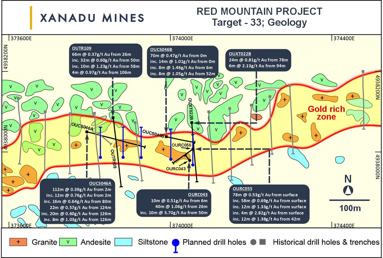
Figure 4: Target 33 showing previous drilling and trenching2 and planned drilling 2024.
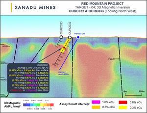
Target 10 – High-Grade Cu and Porphyry Cu-Au Target
Target 10 was first identified in 2017 as a copper and gold in soil anomaly with a molybdenum halo and coincident bullseye magnetic feature. Two diamond drill holes were drilled into the magnetic feature, returning3:
| OUDDH089 | 6.2m @ 4.24% Cu and 1.9g/t Au, from 128m |
| Including | 0.9m @ 22.1%Cu and 8.27g/t Au, from 129m |
| And | 79.5m @ 0.26% Cu and 0.21g/t Au, from 198.5m |
| OUDDH090 | 138m @ 0.27% Cu and 0.25g/t Au, from 200m |
| | |
Current Drilling Program: Three shallow drill holes and one deeper drill hole are planned to follow up on these results. Shallow holes are targeting around the high-grade copper intercept in OUDDH089 and are designed to determine the orientation of this zone, with the aim of delivering further expansion. A single deeper hole is planned to scissor the broad porphyry intercept in OUDDH090, testing the theory that this is associated with a south dipping structure, clearly visible in the magnetics (Figure 5)
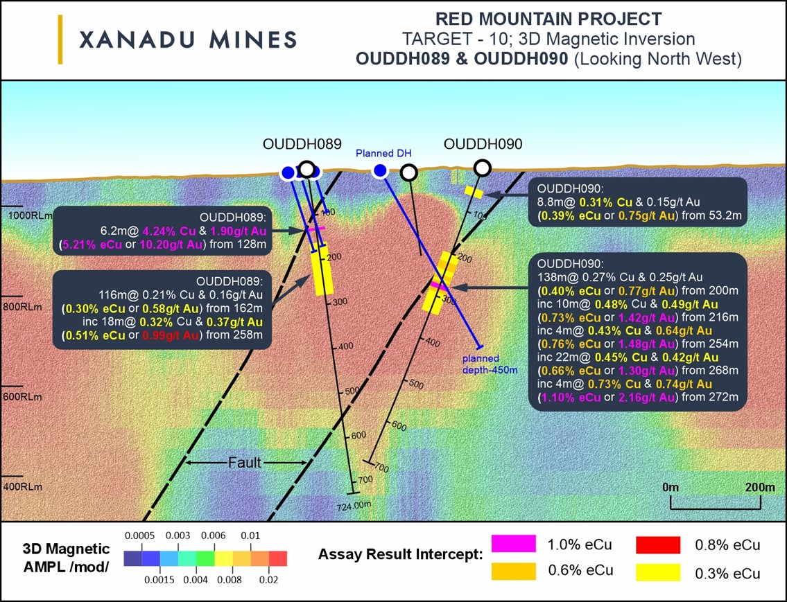
Figure 5: Target 10 showing previous drilling and planned drilling 20244.
Bavuu Porphyry – Porphyry Cu-Au Target
Bavuu Porphyry was first identified in 2016 as a large-scale copper and gold soil anomaly. Trenching completed in 2016 returned very broad porphyry intercepts of copper and gold mineralisation5;
| OUCS030A | 188m @ 0.24% Cu and 0.18g/t Au |
| Including | 52 m @ 0.36% Cu and 0.22g/t Au |
| OUCS030B | 220m @ 0.15% Cu and 0.16g/t Au |
| | |
| Two shallow reverse circulation drill holes were drilled under OUCS030A with the deeper hole returning; |
| OURC032 | 168m @ 0.22% Cu and 0.25g/t Au from surface |
| Including | 32m @ 0.31% Cu and 0.4g/t Au from 132m |
| | |
Current Drilling Program: Two diamond drill holes have been designed to test behind this intercept and along strike to the west (Figure 6).
Figure 6: Target 10 showing previous drilling and planned drilling 20246.
Nowie Porphyry – Porphyry Cu-Au Target
No work has previously been conducted at Nowie by Xanadu. However, multiple drill hole collars and trenches from previous explorers are visible at surface. Soil sampling at Nowie has defined a 500m long copper in soil anomaly greater than 0.1% Cu and 0.25g/t Au. Geological mapping has identified strong oxide copper at surface associated with porphyry veining.
Current Drilling Program: Three diamond drill holes have been designed to test beneath the 500m strike of surface mineralisation.
Stockwork Porphyry – Porphyry Cu-Au Target
Limited work has previously been conducted at Stockwork by Xanadu. However, like the Nowie propsect, multiple drill hole collars and trenches from previous explorers are visible at surface. Soil sampling at Stockwork has defined a 650m long copper in soil anomaly greater than 0.05% Cu. Geological mapping has identified strong oxide copper at surface associated with intense porphyry veining and a reinterpretation based on this mapping has suggested an alternative orientation to drill test for the system at Stockwork.
Current Drilling Program: Three shallow diamond drill holes have been designed to test this target.
About Red Mountain
The 100% owned Red Mountain project, located within the Dornogovi Province of southern Mongolia, approximately 420 kilometres southeast of Ulaanbaatar (Figures 1 and 2).
The project covers approximately 57 square kilometres in a frontier terrane with significant mineral endowment and has a granted 30-year mining licence. Red Mountain comprises a cluster of outcropping mineralising porphyry intrusions which display features typically found in the shallower parts of porphyry systems where narrow dykes and patchy mineralisation branch out above a mineralised stock. This underexplored porphyry district includes multiple porphyry copper-gold centres, mineralised tourmaline breccia pipes copper-gold/base metal skarns and high-grade epithermal gold veins.
Existing porphyry mineralisation at Red Mountain is hosted within narrow stockwork zones that have been focused around several narrow structurally controlled monzonite porphyry dykes. Emplacement of mineralisation appears to be controlled by intersection of northeast and north-northwest trending structures. The quartz-chalcopyrite-bornite stockwork mineralisation is associated with strong reddening albite-sericite-biotite-magnetite (potassic) alteration assemblage in the host lithology. The thin nature of the mineralising dykes, their irregular intrusion geometry, and the patchy distribution of stockwork mineralisation are all features typically found in the shallower parts of porphyry systems, where narrow dykes and patchy mineralisation branch out above a mineralised stock. Similar orebody geometries are found in the shallower parts of the Northparkes porphyry copper-gold (Cu-Au) deposits in NSW, where porphyry mineralisation has also been tightly focused along a controlling structure adjacent to a felsic pluton. Like Northparkes, there is the potential for further mineralisation along the main structures at Diorite Hill and Stockwork Hill, and the likelihood that mineralisation extends (and could amalgamate) at depth.
About Xanadu Mines
Xanadu is an ASX and TSX listed Exploration company operating in Mongolia. We give investors exposure to globally significant, large-scale copper-gold discoveries and low-cost inventory growth. Xanadu maintains a portfolio of exploration projects and remains one of the few junior explorers on the ASX or TSX who jointly control a globally significant copper-gold deposit in our flagship Kharmagtai project. Xanadu is the Operator of a 50-50 JV with Zijin Mining Group in Khuiten Metals Pte Ltd, which controls 76.5% of the Kharmagtai project.
For further information on Xanadu, please visit: www.xanadumines.com or contact:
Colin Moorhead
Executive Chairman & Managing Director
E: colin.moorhead@xanadumines.com
P: +61 2 8280 7497 | |
| | |
This Announcement was authorised for release by Xanadu’s Board of Directors.
Appendix 1: Statements and Disclaimers
Competent Person Statement
The information in this announcement that relates to exploration results is based on information compiled by Dr Andrew Stewart, who is responsible for the exploration data, comments on exploration target sizes, QA/QC and geological interpretation and information. Dr Stewart, who is an employee of Xanadu and is a Member of the Australasian Institute of Geoscientists, has sufficient experience relevant to the style of mineralisation and type of deposit under consideration and to the activity he is undertaking to qualify as the Competent Person as defined in the 2012 Edition of the Australasian Code for Reporting Exploration Results, Mineral Resources and Ore Reserves and the National Instrument 43-101. Dr Stewart consents to the inclusion in the report of the matters based on this information in the form and context in which it appears.
Forward-Looking Statements
Certain statements contained in this Announcement, including information as to the future financial or operating performance of Xanadu and its projects may also include statements which are ‘forward‐looking statements’ that may include, amongst other things, statements regarding targets, estimates and assumptions in respect of mineral reserves and mineral resources and anticipated grades and recovery rates, production and prices, recovery costs and results, capital expenditures and are or may be based on assumptions and estimates related to future technical, economic, market, political, social and other conditions. These ‘forward-looking statements’ are necessarily based upon a number of estimates and assumptions that, while considered reasonable by Xanadu, are inherently subject to significant technical, business, economic, competitive, political and social uncertainties and contingencies and involve known and unknown risks and uncertainties that could cause actual events or results to differ materially from estimated or anticipated events or results reflected in such forward‐looking statements.
Xanadu disclaims any intent or obligation to update publicly or release any revisions to any forward‐looking statements, whether as a result of new information, future events, circumstances or results or otherwise after the date of this Announcement or to reflect the occurrence of unanticipated events, other than required by the Corporations Act 2001 (Cth) and the Listing Rules of the Australian Securities Exchange (ASX) and Toronto Stock Exchange (TSX). The words ‘believe’, ‘expect’, ‘anticipate’, ‘indicate’, ‘contemplate’, ‘target’, ‘plan’, ‘intends’, ‘continue’, ‘budget’, ‘estimate’, ‘may’, ‘will’, ‘schedule’ and similar expressions identify forward‐looking statements.
All ‘forward‐looking statements’ made in this Announcement are qualified by the foregoing cautionary statements. Investors are cautioned that ‘forward‐looking statements’ are not guarantee of future performance and accordingly investors are cautioned not to put undue reliance on ‘forward‐looking statements’ due to the inherent uncertainty therein.
For further information please visit the Xanadu Mines’ Website at www.xanadumines.com.
Appendix 2: Red Mountain Table 1 (JORC Code, 2012)
Set out below is Section 1 and Section 2 of Table 1 under the JORC Code, 2012 for the Red Mountain project. Data provided by Xanadu. This Table 1 updates the JORC Table 1 disclosure dated 27 September 2022.7
1.1 JORC TABLE 1 - SECTION 1 - SAMPLING TECHNIQUES AND DATA
| Criteria | Commentary |
| Sampling techniques | - The exploration results are based on diamond drill core samples, reverse circulation (RC) chip samples and channel samples from surface trenches.
- Representative ½ core samples were split from PQ, HQ & NQ diameter diamond drill core on site using rock saws, on a routine two metre sample interval that also honours lithological/intrusive contacts.
- The orientation of the cut line is controlled using the core orientation line ensuring uniformity of core splitting wherever the core has been successfully oriented.
- Sample intervals are defined and subsequently checked by geologists, and sample tags are attached (stapled) to the plastic core trays for every sample interval.
- RC chip samples are ¼ splits from 1m intervals using a 75%:25% riffle splitter to obtain a 3kg sample.
- RC samples are uniform 2m samples formed from the combination of two ¼ split 1m samples.
- Trench samples are collected as 2m composite from 30m above the trench toe.
- Sampling generally honours lithological contacts.
- Trench samples are continuous along the length of the trench
|
| Drilling techniques | - The exploration results are based upon diamond drilling of PQ, HQ and NQ diameters with both standard and triple tube core recovery configurations, RC drilling and surface trenching with channel sampling.
- All drill core drilled by Xanadu has been oriented using the “Reflex Ace” tool.
|
| Drill sample recovery | - Diamond drill core recoveries were assessed using the standard industry (best) practice which involves removing the core from core trays; reassembling multiple core runs in a v-rail; measuring core lengths with a tape measure, assessing recovery against core block depth measurements and recording any measured core loss for each core run.
- Diamond core recoveries average 97% through mineralisation.
- Overall, core quality is good, with minimal core loss. Where there is localised faulting and or fracturing core recoveries decrease, however, this is a very small percentage of the mineralised intersections.
- RC recoveries are measured using whole weight of each 1m intercept measured before splitting
- Analysis of recovery results vs grade shows no significant trends that might indicate sampling bias introduced by variable recovery in fault/fracture zones.
|
| Logging | - All drill core is geologically logged by well-trained geologists using a modified “Anaconda-style” logging system methodology. The Anaconda method of logging and mapping is specifically designed for porphyry Cu-Au mineral systems.
- Logging of lithology, alteration and mineralogy is intrinsically qualitative in nature. However, the logging is subsequently supported by 4 Acid ICP-MS (48 element) geochemistry and SWIR spectral mineralogy (facilitating semi-quantitative / calculated mineralogical, lithological and alteration classification) which is integrated with the logging to improve cross section interpretation and 3D geological model development.
- Drill core is also systematically logged for both geotechnical features and geological structures. Where drill core has been successfully oriented, the orientation of structures and geotechnical features are also routinely measured.
- Both wet and dry core photos are taken after core has been logged and marked-up but before drill core has been cut.
|
| Sub -sampling techniques and sample preparation | - All drill core samples are ½ core splits from either PQ, HQ or NQ diameter cores. A routine 2m sample interval is used, but this is varied locally to honour lithological/intrusive contacts. The minimum allowed sample length is 30cm.
- Core is appropriately split (onsite) using diamond core saws with the cut line routinely located relative to the core orientation line (where present) to provide consistency of sample split selection.
- The diamond saws are regularly flushed with water to minimize potential contamination.
- A field duplicate ¼ core sample is collected every 30th sample to ensure the “representivity of the in-situ material collected”. The performance of these field duplicates is routinely analysed as part of Xanadu’s sample QC process.
- Routine sample preparation and analyses of DDH samples were carried out by ALS Mongolia LLC (ALS Mongolia), who operates an independent sample preparation and analytical laboratory in Ulaanbaatar.
- All samples were prepared to meet standard quality control procedures as follows: Crushed to 75% passing 2mm, split to 1kg, pulverised to 85% passing 200 mesh (75 microns) and split to 150g sample pulp.
- ALS Mongolia Geochemistry labs quality management system is certified to ISO 9001:2008.
- The sample support (sub-sample mass and comminution) is appropriate for the grainsize and Cu-Au distribution of the porphyry Cu-Au mineralization and associated host rocks.
- Trench samples by previous explorers between 2001 to 2007 were prepared and assayed by SGS Mongolia.
|
| Quality of assay data and laboratory tests | - All XAM samples were routinely assayed by ALS Mongolia for gold.
- Au is determined using a 25g fire assay fusion, cupelled to obtain a bead, and digested with Aqua Regia, followed by an atomic absorption spectroscopy (AAS) finish, with a lower detection limit (LDL) of 0.01 ppm.
- All samples were also submitted to ALS Mongolia for the 48-element package ME-ICP61 using a four-acid digest (considered to be an effective total digest for the elements relevant to the MRE). Where copper is over-range (>1% Cu), it is analysed by a second analytical technique (Cu-OG62), which has a higher upper detection limit (UDL) of 5% copper.
- Quality assurance has been managed by insertion of appropriate Standards (1:30 samples - suitable Ore Research Pty Ltd certified standards), Blanks (1:30 samples), Duplicates (1:30 samples - ¼ core duplicate) by Xanadu.
- Assay results outside the optimal range for methods were re-analysed by appropriate methods.
- Ore Research Pty Ltd certified copper and gold standards have been implemented as a part of QC procedures, as well as coarse and pulp blanks, and certified matrix matched copper-gold standards.
- QC monitoring is an active and ongoing processes on batch-by-batch basis by which unacceptable results are re-assayed as soon as practicable.
- Prior to 2014: Cu, Ag, Pb, Zn, As and Mo were routinely determined using a three-acid-digestion of a 0.3g sub-sample followed by an AAS finish (AAS21R) at SGS Mongolia. Samples were digested with nitric, hydrochloric and perchloric acids to dryness before leaching with hydrochloric acid to dissolve soluble salts and made to 15ml volume with distilled water. The LDL for copper using this technique was 2ppm. Where copper was over-range (>1% Cu), it was analysed by a second analytical technique (AAS22S), which has a higher upper detection limit (UDL) of 5% copper. Gold analysis method was essentially unchanged.
- Trenching samples from 2001 to 2007 were analysed for 6 elements (Cu, Ag, Pb, Zn, As and Mo) by SGS Mongolia using a three-acid-digestion of a 0.3g sub-sample followed by an AAS finish (AAS21R). Samples were digested with nitric, hydrochloric and perchloric acids to dryness before leaching with hydrochloric acid to dissolve soluble salts and made to 15ml volume with distilled water. The LDL for copper using this technique was 2ppm. Where copper was over-range (>1% Cu), it was analysed by a second analytical technique (AAS22S), which has a higher upper detection limit (UDL) of 5% copper. Gold analysis method was essentially unchanged.
|
| Verification of sampling and assaying | - All assay data QA/QC is checked prior to loading into Xanadu’s Geobank data base.
- The data is managed by Xanadu geologists.
- The data base and geological interpretation is managed by Xanadu.
- Check assays are submitted to an umpire lab (SGS Mongolia) for duplicate analysis.
- No twinned drill holes exist.
- There have been no adjustments to any of the assay data.
|
| Location of data points | - Diamond drill holes have been surveyed with a differential global positioning system (DGPS) to within 10cm accuracy.
- The grid system used for the project is UTM WGS-84 Zone 49N
- Historically, Eastman Kodak and Flexit electronic multi-shot downhole survey tools have been used at Red Mountain to collect down hole azimuth and inclination information for the majority of the diamond drill holes. Single shots were typically taken every 30m to 50m during the drilling process, and a multi-shot survey with readings every 3-5m are conducted at the completion of the drill hole. As these tools rely on the earth’s magnetic field to measure azimuth, there is some localised interference/inaccuracy introduced by the presence of magnetite in some parts of the Red Mountain mineral system. The extent of this interference cannot be quantified on a reading-by-reading basis.
- More recently (since September 2017), a north-seeking gyro has been employed by the drilling crews on site (rented and operated by the drilling contractor), providing accurate downhole orientation measurements unaffected by magnetic effects. Xanadu have a permanent calibration station setup for the gyro tool, which is routinely calibrated every 2 weeks (calibration records are maintained and were sighted).
- The project DTM is based on 1 m contours from satellite imagery with an accuracy of ±0.1 m.
- Trenching locations for trenches between 2001 and 2007 were located using a handheld GPS.
|
| Data spacing and distribution | - Holes spacings range from <50m spacings within the core of mineralisation to +500m spacings for exploration drilling. Hole spacings can be determined using the sections and drill plans provided.
- Holes range from vertical to an inclination of -60 degrees depending on the attitude of the target and the drilling method.
- The data spacing and distribution is sufficient to establish anomalism and targeting for porphyry Cu-Au, tourmaline breccia and epithermal target types.
- Holes have been drilled to a maximum of 1,300m vertical depth.
- The data spacing and distribution is sufficient to establish geological and grade continuity.
|
| Orientation of data in relation to geological structure | - Drilling is conducted in a predominantly regular grid to allow unbiased interpretation and targeting.
- Scissor drilling, as well as some vertical and oblique drilling, has been used in key mineralised zones to achieve unbiased sampling of interpreted structures and mineralised zones, and in particular to assist in constraining the geometry of the mineralised hydrothermal tourmaline-sulphide breccia domains.
|
| Sample security | - Samples are delivered from the drill rig to the core shed twice daily and are never left unattended at the rig.
- Samples are dispatched from site in locked boxes transported on Xanadu company vehicles to ALS lab in Ulaanbaatar.
- Sample shipment receipt is signed off at the Laboratory with additional email confirmation of receipt.
- Samples are then stored at the lab and returned to a locked storage site.
|
| Audits or reviews | - Internal audits of sampling techniques and data management are undertaken on a regular basis, to ensure industry best practice is employed at all times.
- External reviews and audits have been conducted by the following groups:
- 2012: AMC Consultants Pty Ltd. was engaged to conduct an Independent Technical Report which reviewed drilling and sampling procedures. It was concluded that sampling and data record was to an appropriate standard.
- 2013: Mining Associates Ltd. was engaged to conduct an Independent Technical Report to review drilling, sampling techniques and QA/QC. Methods were found to conform to international best practice.
|
1.2 JORC TABLE 1 - SECTION 2 - REPORTING OF EXPLORATION RESULTS
(Criteria in this section apply to all succeeding sections).
| Criteria | Commentary |
Mineral
tenement
and land
tenure
status | - The Project comprises 1 Mining Licence (MV-17129A).
- Xanadu now owns 90% of Vantage LLC, the 100% owner of the Oyut Ulaan mining licence.
- The Mongolian Minerals Law (2006) and Mongolian Land Law (2002) govern exploration, mining and land use rights for the project.
|
Exploration
done by
other parties | - Previous exploration was conducted by Quincunx Ltd, Ivanhoe Mines Ltd and Turquoise Hill Resources Ltd including extensive drilling, surface geochemistry, geophysics, mapping.
|
Geology
| - The mineralisation is characterised as porphyry copper-gold type.
- Porphyry copper-gold deposits are formed from magmatic hydrothermal fluids typically associated with felsic intrusive stocks that have deposited metals as sulphides both within the intrusive and the intruded host rocks. Quartz stockwork veining is typically associated with sulphides occurring both within the quartz veinlets and disseminated thought out the wall rock. Porphyry deposits are typically large tonnage deposits ranging from low to high grade and are generally mined by large scale open pit or underground bulk mining methods. The deposits at Red Mountain are atypical in that they are associated with intermediate intrusions of diorite to quartz diorite composition; however, the deposits are in terms of contained gold significant, and similar gold-rich porphyry deposits.
|
Drill hole
Information | - Diamond drill holes are the principal source of geological and grade data for the Project.
- See figures in this ASX/TSX Announcement.
|
Data
Aggregation methods | - A nominal cut-off of 0.1% CuEq is used in copper dominant systems for identification of potentially significant intercepts for reporting purposes. Higher grade cut-offs are 0.3%, 0.6% and 1% CuEq.
- A nominal cut-off of 0.1g/t AuEq is used in gold dominant systems like for identification of potentially significant intercepts for reporting purposes. Higher grade cut-offs are 0.3g/t, 0.6g/t and 1g/t AuEq.
- Maximum contiguous dilution within each intercept is 9m for 0.1%, 0.3%, 0.6% and 1% CuEq.
- Most of the reported intercepts are shown in sufficient detail, including maxima and subintervals, to allow the reader to make an assessment of the balance of high and low grades in the intercept.
- Informing samples have been composited to two metre lengths honouring the geological domains and adjusted where necessary to ensure that no residual sample lengths have been excluded (best fit).
- The copper equivalent (CuEq) calculation represents the total metal value for each metal, multiplied by the conversion factor, summed and expressed in equivalent copper percentage with a metallurgical recovery factor applied.
- Copper equivalent (CuEq or eCu) grade values were calculated using the following formula:
- CuEq = Cu + Au * 0.62097 * 0.8235,
- Gold Equivalent (AuEq or eAu) grade values were calculated using the following formula:
- AuEq = Au + Cu / 0.62097 * 0.8235
- Where: Cu = copper grade (%); Au = gold grade (g/t); 0.62097 = conversion factor (gold to copper); 0.8235 = relative recovery of gold to copper (82.35%)
- The copper equivalent formula was based on the following parameters (prices are in USD):
- Copper price = 3.1 $/lb (or 6834 $/t)
- Gold price = 1320 $/oz
- Copper recovery = 85%
- Gold recovery = 70%
- Relative recovery of gold to copper = 70% / 85% = 82.35%.
|
Relationship between mineralisation
on widths
and intercept
lengths | - Mineralised structures are variable in orientation, and therefore drill orientations have been adjusted from place to place in order to allow intersection angles as close as possible to true widths.
- Exploration results have been reported as an interval with 'from' and 'to' stated in tables of significant economic intercepts. Tables clearly indicate that true widths will generally be narrower than those reported.
|
| Diagrams | - See figures in this ASX/TSX Announcement.
|
Balanced
Reporting | - Exploration results have been reported at a range of cut-off grades, above a minimum suitable for open pit mining, and above a minimum suitable for underground mining.
|
Other
substantive
exploration
data | - Extensive work in this area has been done and is reported separately.
|
Further
Work | - The mineralisation is open at depth and along strike.
- Current estimates are restricted to those expected to be reasonable for open pit mining. Limited drilling below this depth (-300m RL) shows widths and grades potentially suitable for underground extraction.
- Exploration ongoing.
|
1.3 JORC TABLE 1 - SECTION 3 ESTIMATION AND REPORTING OF MINERAL RESOURCES
Mineral Resources are not reported so this is not applicable to this report.
1.4 JORC TABLE 1 - SECTION 4 ESTIMATION AND REPORTING OF ORE RESERVES
Ore Reserves are not reported so this is not applicable to this report.
1 ASX Announcement – Oyut Ulaan Exploration Update, 28th June 2017, ASX Announcement – XAM Quarterly Report Q2 2017 Final
2 ASX Announcement – Oyut Ulaan Exploration Update, 28th June 2017, ASX Announcement – XAM Quarterly Report Q2 2017 Final
3 ASX Announcement – Oyut Ulaan Exploration Update – High Grade Massive Sulphide Mineralisation Intersected, 19 July 2017
4 ASX Announcement – Oyut Ulaan Exploration Update – High Grade Massive Sulphide Mineralisation Intersected, 19 July 2017
5 XAM Quarterly Activities Report, Quarter Ending 31 December 2016 and XAM Quarterly Activities Report, Quarter Ending 31 March 2017
6 XAM Quarterly Activities Report, Quarter Ending 31 December 2016 and XAM Quarterly Activities Report, Quarter Ending 31 March 2017
7 ASX/TSX Announcement 27 September 2022 – Broad, shallow gold zone at Red Mountain
Photos accompanying this announcement are available at:
https://www.globenewswire.com/NewsRoom/AttachmentNg/ab346f65-20aa-4c77-a3a2-c675bed03215
https://www.globenewswire.com/NewsRoom/AttachmentNg/a00507a3-2ea1-4e35-8824-10d7224137ea
https://www.globenewswire.com/NewsRoom/AttachmentNg/ac18cc1e-0f5c-4ecc-b5ce-08d2b2a3846a
https://www.globenewswire.com/NewsRoom/AttachmentNg/918d6130-0a43-4c4a-acbd-450f982947d6
https://www.globenewswire.com/NewsRoom/AttachmentNg/7a3262d9-fd1d-4ccf-8699-355a23bead0e
https://www.globenewswire.com/NewsRoom/AttachmentNg/6c230dd0-e983-4ca5-a0fe-e9e47ebda5a6


Figure 1
Map of Mongolia, showing location of the Red Mountain Mining Lease.
Figure 2
The Red Mountain Mining Lease with designed drill holes and target locations.
Figure 3
Exploration drilling has commenced at Red Mountain.
Figure 4
Target 33 showing previous drilling and trenching(2) and planned drilling 2024.
Figure 5
Target 10 showing previous drilling and planned drilling 2024(4).
Figure 6
Target 10 showing previous drilling and planned drilling 2024(6).
Source:
Xanadu Mines Ltd.2024 GlobeNewswire, Inc., source Press Releases - Canada