Highlight of Phase 2 2023 Drilling Program and Plans for 2024
- Hole 18 (23-LC-018) discovered 2 new wide intercepts of 41 metres (324m-365m) and 21 metres (395m-417m) with radioactivity up to 6,200 counts per second (“cps”) below historical drilling.
- Hole 18 intersected asimilar ~200-metre interval (213m-417m) of intermittent uranium-bearing structures up to 8,000 cps, extending downdip from historical drillhole 12-LCM-015 that ended at 300m.
- Phase 2 assays are enroute to the
Saskatchewan Research Council inSaskatoon for processing, and assay results for all 18 holes are expected in November. - Focal point of 2024 drill program is expected to be:
- Following up on the 200m interval from hole 18, including the 2 new wide intercepts of 41m and 21m from Phase 2;
- Following up on the potential new lens identified just south of the
Main Zone mineralization with radioactivity up to 11,000 cps from Phase 1; and - Continuing to work outside of
Main Zone within the Lac 50 trend.
Figure 1: Location of Phase 1 and Phase 2 drillholes, and potential new lens within the Lac 50 Trend.
2023 Angilak Drill Program
The 2023 Angilak drill program consisted of a total of 5,665 metres in 18 holes all focused on the
Hole 18 (23-LC-018) was designed as a downdip follow-up to test the continuity of a wide interval (~200 metres downhole width) from historical drillhole 12-LCM-015 that showed intermittent mineralization from approximately 100 metres downhole to the end of the hole at 300 metres. Results from hole 18 (23-LC-018) show radioactivity up to 8,000 cps was intersected in quartz-carbonate-graphitic structures at approximately 213 metres and intermittent anomalous radioactivity continues downhole to 417 metres, coinciding with an approximately 200-metre interval of intermittent anomalous structures in historical drillhole 12-LCM-015.
There are 2 significant results of hole 18 that require further geological work and are expected to be a focal point of the 2024 drill program. First, hole 18 (23-LC-018) appears to demonstrate downhole continuity from historical hole 12-LCM-015. Second, there are 2 wide intervals of 40.6 metres (324.2m-364.8m) and 21.3 metres (395.3 m-416.6 m) with up to 6,200 cps below the historical hole that ended at 300 metres.
Hole 16 (23-LC-016B) was designed to fill in an approximate 100-metre gap up-dip of historical drillhole 11-LC-005. Up to 3,090 cps was intersected in a quartz-carbonate vein, along strike of a historical intercept approximately 25 metres downhole.
Hole 17 (23-LC-017) was designed to test the continuity of structure and mineralization in the northwest extension of the
| Table 1: Results from Phase 2 Drill Program at Angilak | |||||
| Drillhole7 | From (metres) | To (metres) | Length (metres) | Equivalent | |
| 23-LC-001 Easting: 519795.7 Northing: 6939864.5 Elev: 205.5 m Az: 25, Dip: -55 EOH: 234.0 m | 28.5 | 234.0 | 205.5 | Background | x 1.0 |
| 23-LC-002 Easting: 519322.2 Northing: 6939971.0 Elev: 211.2 mm Az: 26, Dip: -55 EOH: 260.0 m | 95.6 | 96.1 | 0.5 | 130 – 800 | x 4.0 |
| 125.6 | 126.0 | 0.4 | 200 – 3,700 | x 18.5 | |
| 23-LC-003 Easting: 519669.7 Northing: 6939766.7 Elev: 204.3 Az: 26, Dip: -55 EOH: 197.0 m | 112.1 | 112.6 | 0.5 | 230 – 500 | x 2.5 |
| 23-LC-004 Easting: 519002.3 Northing: 6939999.0 Elev: 214.2 m Az: 24, Dip: -55 EOH: 317.0 m | 55.5 | 58.8 | 3.3 | 400 – 3,700 | x 18.5 |
| 61.0 | 67.0 | 6.0 | 500 – 2,500 | x 12.5 | |
| 69.7 | 70.1 | 0.4 | 500 – 2,500 | x 12.5 | |
| 70.7 | 70.9 | 0.2 | 500 – 800 | x 4.0 | |
| 78.5 | 78.9 | 0.4 | 500 – 2,500 | x 12.5 | |
| 23-LC-005 Easting: 519489.8 Northing: 6939862.9 Elev: 208.5 m Az: 26, Dip: -70 EOH: 266.1 m | 165.4 | 165.5 | 0.1 | 4,500 | x 22.5 |
| 218.0 | 219.4 | 1.4 | 715 – 65,535 | x 328.0 | |
| 23-LC-006 Easting: 519002.3 Northing: 6939998.7 Elev: 214.2 m Az: 24, Dip: -70 EOH: 362.0 m | 70.2 | 80.0 | 9.8 | 130 – 7,000 | x 35.0 |
| 101.0 | 104.7 | 3.7 | 200 – 1,700 | x 8.5 | |
| 23-LC-007 Easting: 519308.0 Northing: 6939835.3 Elev: 210.1 m Az: 25, Dip: -60 EOH: 380.0 m | 248.3 | 248.9 | 0.6 | 320 – 910 | x 4.6 |
| 250.1 | 250.3 | 0.2 | 635 – 800 | x 4.0 | |
| 275.2 | 275.4 | 0.2 | 825 – 850 | x 4.3 | |
| 23-LC-008 Easting: 518957.1 Northing: 6939964.1 Elev: 216.1 m Az: 23, Dip: -74 EOH: 402.8 m | 115.5 | 115.7 | 0.2 | 1,000 – 3,000 | x 15.0 |
| 125.9 | 130.3 | 4.4 | 130 – 11,000 | x 55.0 | |
| 131.1 | 134.0 | 2.9 | 130 – 6,000 | x 3.0 | |
| 142.9 | 143.4 | 0.5 | 600 – 3,000 | x 15.0 | |
| 164.0 | 164.2 | 0.2 | 1,000 – 1,500 | x 7.5 | |
| 23-LC-009 Easting: 519145.9 Northing: 6940063.5 Elev: 214.0 m Az: 2, Dip: -72 EOH: 242.0 m | 0.7 | 0.9 | 0.2 | 950 – 1,250 | x 6.3 |
| 35.1 | 35.4 | 0.3 | 1,000 – 5,080 | x 25.4 | |
| 58.7 | 59.2 | 0.5 | 400 – 3,390 | x 17.0 | |
| 59.5 | 59.9 | 0.4 | 600 – 1,400 | x 7.0 | |
| 60.1 | 60.2 | 0.1 | 1,410 – 1,450 | x 7.3 | |
| 62.4 | 62.6 | 0.2 | 660 – 775 | x 3.9 | |
| 64.8 | 64.9 | 0.1 | 850 – 925 | x 4.7 | |
| 75.5 | 75.7 | 0.2 | 1,100 – 3,300 | x 16.5 | |
| 77.0 | 77.4 | 0.4 | 450 – 9,050 | x 45.3 | |
| 175.2 | 175.5 | 0.3 | 3,500 – 7,400 | x 37.0 | |
| 23-LC-010 Easting: 519145.7 Northing: 6940062.9 Elev: 213.9 m Az: 12, Dip: -85 EOH: 326.0 m | 86.7 | 86.9 | 0.2 | 900 | x 3.9 |
| 96.3 | 96.4 | 0.1 | 770 | x 4.5 | |
| 100.2 | 101.0 | 0.8 | 6,750 – 9,200 | x 46.0 | |
| 106.0 | 106.7 | 0.7 | 1,100 – 14,450 | x 72.3 | |
| 134.0 | 134.2 | 0.2 | 750 – 2,200 | x 11.0 | |
| 23-LC-011 Easting: 518718.7 Northing: 6940232.1 Elev: 218.6 m Az: 25, Dip: -54 EOH: 215.0 m | 45.9 | 46.3 | 0.4 | 1,500 – 2,000 | x 10.0 |
| 46.8 | 47.0 | 0.2 | 1,500 – 2,000 | x 10.0 | |
| 81.5 | 81.7 | 0.2 | 2,000 – 3,500 | x 17.5 | |
| 118.0 | 118.2 | 0.2 | 1,000 – 1,200 | x 6.0 | |
| 133.4 | 133.5 | 0.1 | 900 – 1,000 | x 5.0 | |
| 170.7 | 170.8 | 0.1 | 1,000 – 2,000 | x 10.0 | |
| 171.2 | 171.7 | 0.5 | 800 – 21,000 | x 105.0 | |
| 172.0 | 172.1 | 0.1 | 1,000 – 3,000 | x 15.0 | |
| 23-LC-012 Easting: 518458.1 Northing: 6940273.5 Elev: 233.6 m Az: 26, Dip: -60 EOH: 347.0 m | 72.8 | 73.5 | 0.7 | 300 – 800 | x 4.0 |
| 113.3 | 113.5 | 0.2 | 900 – 1,200 | x 6.0 | |
| 130.0 | 130.3 | 0.3 | 900 – 1,000 | x 5.0 | |
| 232.1 | 232.4 | 0.3 | 875 – 1,400 | x 7.0 | |
| 234.8 | 235.9 | 1.1 | 800 – 15,000 | x 75.0 | |
| 236.3 | 236.7 | 0.4 | 800 – 1,300 | x 6.5 | |
| 255.3 | 255.5 | 0.2 | 1,000 – 1,400 | x 6.5 | |
| 282.9 | 283.2 | 0.3 | 800 – 1,000 | x 5.0 | |
| 286.6 | 286.7 | 0.1 | 800 | x 4.0 | |
| 308.6 | 308.7 | 0.1 | 1,000 | x 5.0 | |
| 23-LC-013A Easting: 519064.3 Northing: 6939973.8 Elev: 213.3 m Az: 12, Dip: -80.5 EOH: 413.0 m | 76.7 | 77.2 | 0.5 | 650 – 1,200 | x 6.0 |
| 80.2 | 80.6 | 0.4 | 750 – 1,000 | x 5.0 | |
| 84.6 | 84.8 | 0.2 | 800 – 1,100 | x 5.5 | |
| 283.1 | 283.7 | 0.6 | 840 – 5,740 | x 28.7 | |
| 23-LC-014 Easting: 518458.3 Northing: 6940273.9 Elev: 233.3 m Az: 25, Dip: -70 EOH: 362.0 m | 139.2 | 139.3 | 0.1 | 1,000 | x 5.0 |
| 139.9 | 140.3 | 0.4 | 1,000 – 11,000 | x 55.0 | |
| 258.6 | 258.8 | 0.2 | 1,000 – 3,500 | x 17.5 | |
| 268.8 | 268.9 | 0.1 | 1,000 | x 5.0 | |
| 288.6 | 288.7 | 0.1 | 2,600 | x 13.0 | |
| 23-LC-015 Easting: 518202.0 Northing: 6940390.5 Elev: 236.0 m Az: 28, Dip: -60 EOH: 359.0 m | 87.9 | 88.2 | 0.3 | 970 – 2,300 | x 11.5 |
| 170.5 | 170.8 | 0.3 | 805 – 4,400 | x 22.0 | |
| 230.0 | 230.3 | 0.3 | 2,000 – 24,500 | x 122.5 | |
| 241.2 | 241.3 | 0.1 | 920 | x 4.6 | |
| 274.5 | 274.6 | 0.1 | 970 | x 4.9 | |
| 280.9 | 281.0 | 0.1 | 945 | x 4.7 | |
| 282.0 | 282.1 | 0.1 | 1,055 | x 5.3 | |
| 282.5 | 282.6 | 0.1 | 720 | x 3.6 | |
| 295.0 | 295.2 | 0.2 | 780 – 1,300 | x 6.5 | |
| 299.1 | 299.5 | 0.4 | 900 – 30,800 | x 154.0 | |
| 299.6 | 300.0 | 0.4 | 845 – 10,375 | x 51.9 | |
| 23-LC-016B Easting: 518401.6 Northing: 6940485.8 Elev: 234.5 m Az: 24, Dip: -60 EOH: 143.0 m | 24.9 | 25.0 | 0.1 | 897 | x 4.5 |
| 25.0 | 25.1 | 0.1 | 3090 | x 15.5 | |
| 23-LC-017 Easting: 518024.4 Northing: 6940421.3 Elev: 235.0 m Az: 35, Dip: -45 EOH: 302.0 m | 152.7 | 157 | 4.3 | 210 – 870 | x 4.4 |
| 199.2 | 203.3 | 4.10 | 221 – 770 | x 3.9 | |
| 266.5 | 270.8 | 4.3 | 160 – 710 | x 3.6 | |
| 23-LC-018 Easting: 518205.8 Northing: 6940320.3 Elev: 234.4 m Az: 26, Dip: -60 EOH: 444.0 m | 34.2 | 35.7 | 1.5 | 400 – 2,020 | x 10.1 |
| 112.9 | 113.1 | 0.2 | 1,500 – 1,600 | x 8.0 | |
| 212.9 | 213.6 | 0.7 | 860 – 8,000 | x 40.0 | |
| 253.1 | 253.3 | 0.2 | 1,100 – 1,200 | x 6.0 | |
| 262.3 | 262.4 | 0.1 | 1,200 | x 6.0 | |
| 300.7 | 305.3 | 4.6 | 170 – 1,600 | x 8.0 | |
| 324.2 | 364.8 | 40.6 | 170 – 2,550 | x 12.8 | |
| 395.3 | 416.6 | 21.3 | 170 – 6,200 | x 31.0 | |
1. See Figure 1 for drillhole locations.
2. Radioactivity is total gamma in cps (counts per second) measured directly from drill core using a recently calibrated RS230 spectrometer.
3. The Company considers all spectrometer readings greater than 200 cps to constitute elevated radioactivity, with background radioactivity measuring less than 200 cps. Anomalous radioactivity is defined as anything over 700 cps.
4. Measurements of cps on drill core are an indication of the presence of radioactive materials (uranium, thorium, and/or potassium), but may not directly correlate with uranium chemical assays. Total cps readings are preliminary and may not be used directly to quantify or qualify uranium concentrations of the rock samples measured.
5. All reported depths and intervals are drill hole depths and intervals, unless otherwise noted, and do not represent true thicknesses, which have yet to be determined.
6. Cps values are given as continuous composite elevated radioactivity (sum of drill core length greater than or equal to the minimum value for that interval). During logging, cps is measured as 10 cm intervals through the radioactive zone and 1 – 2 m above and below into background radioactive core. This is performed when any measurements are above 200 cps. Data is measured and recorded by a trained geotechnician and verified by the onsite supervising geologist.
7. Previous drillhole location data updated with Differential Global Positioning Systems (DGPSs) data.
Qualified Person (QP)
The technical information in this news release has been reviewed and approved by
About
Latitude Uranium is exploring and developing two district-scale uranium projects in
For More Information, Please Contact:
CEO
jjentz@latitudeuranium.com
Toll-Free: 1-833-572-2333
Email: info@latitudeuranium.com
Website: www.latitudeuranium.com
Twitter: @LatitudeUr
LinkedIn: https://www.linkedin.com/company/latitude-uranium-inc/
Cautionary Statement Regarding “Forward-Looking” Information
This news release contains “forward-looking information” within the meaning of applicable Canadian securities laws. “Forward-looking information” includes, but is not limited to, statements with respect to activities, events or developments that the Company expects or anticipates will or may occur in the future including, but not limited to, the expected timing and results of Phase 2 of the drill program; the Company’s planned exploration focus for 2024; the Company’s ongoing business plan, sampling, exploration and work programs. Generally, but not always, forward-looking information and statements can be identified by the use of words such as “plans”, “expects”, “is expected”, “budget”, “scheduled”, “estimates”, “forecasts”, “intends”, “anticipates”, or “believes” or the negative connotation thereof or variations of such words and phrases or statements that certain actions, events or results “may”, “could”, “would”, “might” or “will be taken”, “occur” or “be achieved” or the negative connotation thereof.
Forward-looking information and statements are based on our current expectations, beliefs, assumptions, estimates and forecasts about LUR’s business and the industry and markets in which it operates. Such forward information and statements are based on numerous assumptions, including among others, that general business and economic conditions will not change in a material adverse manner, that locations of historical mineral resources estimates could lead to new mineralization discoveries and potentially be verified as current mineral resource estimates, that financing will be available if and when needed and on reasonable terms to conduct further exploration and operational activities, and that third party contractors, equipment and supplies and governmental and other approvals required to conduct LUR’s planned exploration activities will be available on reasonable terms and in a timely manner. Although the assumptions made by LUR in providing forward-looking information or making forward-looking statements are considered reasonable by management at the time, there can be no assurance that such assumptions will prove to be accurate.
Forward-looking information and statements also involve known and unknown risks and uncertainties and other factors, which may cause actual results, performances and achievements of LUR to differ materially from any projections of results, performances and achievements of LUR expressed or implied by such forward-looking information or statements, including, among others: limited operating history, negative operating cash flow and dependence on third party financing, uncertainty of additional financing, delays or failure to obtain required permits and regulatory approvals, no known mineral resources/reserves, aboriginal title and consultation issues, reliance on key management and other personnel; potential downturns in economic conditions; availability of third party contractors; availability of equipment and supplies; failure of equipment to operate as anticipated; accidents, effects of weather and other natural phenomena and other risks associated with the mineral exploration industry; changes in laws and regulation, competition, and uninsurable risks, community relations, delays in obtaining governmental or other approvals and the risk factors with respect to LUR set out in LUR’s annual information form in respect of the year ended
Although LUR has attempted to identify important factors that could cause actual actions, events or results to differ materially from those contained in the forward-looking information or implied by forward-looking information, there may be other factors that cause results not to be as anticipated, estimated or intended. There can be no assurance that forward-looking information and statements will prove to be accurate, as actual results and future events could differ materially from those anticipated, estimated or intended. Accordingly, readers should not place undue reliance on forward-looking statements or information. LUR undertakes no obligation to update or reissue forward-looking information as a result of new information or events except as required by applicable securities laws.
A photo accompanying this announcement is available at https://www.globenewswire.com/NewsRoom/AttachmentNg/006ac9f7-5ae5-4107-9ad9-c1163be26bf2

![]()
Figure 1: Location of Phase 1 and Phase 2 drillholes, and potential new lens within the Lac 50 Trend.
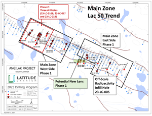
Figure 1: Location of Phase 1 and Phase 2 drillholes, and potential new lens within the Lac 50 Trend.
2023 GlobeNewswire, Inc., source