- Three reverse circulation (“RC”) holes on northern IP anomaly to depths of 774 - 823 ft, for 2,402 ft in total (732 m).
- Each hole successfully intersected continuous silica-sulphide alteration through its entirety.
- Water pressure at the 800 ft level resulted in the termination of each RC hole. Each hole bottomed in the silica-sulfide alteration in the core of the IP anomaly.
Figure 1 and Figure 2 show photographs of drill chips which are mostly quartz-adularia altered tuff, hydrothermal quartz with sulfide, individual sulfide grains and sulfide clots, and tuffisite breccia with silica flooding and disseminated sulfide.
A total of 534 samples were collected in continuous sequence in order to completely capture the alteration intersected throughout the entirety of each hole. The samples have been received by the ALS laboratory in
Figure 3 shows the location of the three holes, which test along the strike of, and across, the northwest-trending axis of the northern IP anomaly and corresponding airborne radiometric potassium anomaly which corresponds to quartz-adularia alteration in rhyolite tuff and tuffisite breccia mapped on surface.
The cross-section in Figure 4 illustrates how the three RC holes just completed to the 800 ft level bottomed in silica-sulfide alteration in the core of the northern IP anomaly.
CEO Comment
From VR’s CEO Dr.
We used state-of-the-art 3D-array DCIP technology for drill targeting because the DCIP survey maps sulfide chargeability, and VR’s mapping and prospecting along the 20 km long Big Ten mineral trend has established a strong correlation between gold mineralization and pyrite-bearing quartz veins and pyrite in altered tuffisite breccia. An example is provided at the end of Big Ten – Amsel project page on the Company’s website, with a photograph and 58 g/t gold assay for a rock sample of altered tuff with pyrite from the Company’s Clipper Property located 10 km southeast along trend from Amsel.
Further, the relationship of gold mineralization to pyrite is well established at the 20Moz Round Mtn. gold deposit located 45 km to the northwest of Amsel, and hosted in a Tertiary rhyolite caldera of the same age.
The sulfide-bearing alteration intersected from top to bottom in the three RC drill holes just completed demonstrates that the DCIP technology deployed in 2019 was the right tool to identify the core of the broad silica-adularia, potassium alteration footprint evident on surface at Amsel.
On face value, the plan map and section of the IP data in Figures 3 and 4 make clear that despite the breadth of sulfide alteration intersected throughout all three of the 800 ft holes just completed in the northern IP anomaly, the southern IP anomaly anchored by the opposing southern volcanic horst fault appears to be, by comparison: 1. larger in plan view; 2. more deeply rooted; 3. higher amplitude chargeability (greater sulfide content), and 4. is below a surface gold-silver geochemical anomaly that includes the high temperature indicator assemblage of thallium-tungsten-moly and lead indicative of proximity to the source of the overall epithermal gold fluid system at Amsel.
Suffice it to say, and pending assays of course, our conviction is now strengthened to follow-up the sulfide alteration intersected in these initial RC holes by using diamond drilling this summer for the second leg of this first pass drilling so that we can properly test the full depth extent of the epithermal system at Amsel that is responsible for the surface alteration footprint covering some 2 x 3 km on the hill top.”
Going Forward
Drilling is planned to resume in late-spring/early summer when weather conditions are more favourable for drilling on the slopes of the hill at Amsel, especially the southern IP anomaly on the south flank.
The second leg of this first-pass drilling will include the first holes into the larger southern IP anomaly, anchored to the southern volcanic horst fault. In addition, we plan to use the diamond drill to properly evaluate the full depth extent and mineral potential of the sulfide alteration intersected in the three initial RC holes just completed into the northern IP anomaly.
About the
Property Location and Description
The Big Ten project is located in
There are currently seven properties along the 20 km length of the Big Ten mineral trend. They total 117 claims covering 2,417 acres. Each property is a single, contiguous claim block. The properties are owned 100% by VR, registered to the Company’s wholly-owned,
Geology and History
The Big Ten Tertiary volcanic caldera is located along the eastern margin of the
Corporation). The correlation of adularia and pyrite alteration with gold at Amsel and along the 20km Big Ten trend is also well documented at the low-sulfidation epithermal system at
The current Big Ten land package held by VR is the result of reconnaissance surface exploration from 2017 through 2020, including a high resolution, airborne magnetic and radiometric survey and an airborne hyperspectral survey used to map alteration minerals. Integrated results from the exploration define a structural corridor and mineral trend 20 km long which transects the entire Big Ten volcanic caldera.
Amsel has been the focus of exploration since 2019, based on the sheer size of its quartz-adularia alteration footprint. There are historic workings at Amsel from the 1920’s, and cursory exploration in the late 1970’s, with no modern or systematic exploration since. VR has the opportunity to be the first Company to use new exploration technologies on the large-scale alteration system that were not available in the 1970’s, and similarly, to apply current mineral deposit models developed for epithermal gold and silver deposits in the
The Company’s website at www.vrr.ca provides a more complete overview of the Big Ten epithermal gold project, including locations and descriptions of the seven individual properties, select property-scale plan maps with gold-silver assays from surface grab samples, and field photographs of epithermal textures in sulfide-bearing quartz veins. Included is a bulleted summary of the various airborne surveys and surface exploration programs completed by VR during the past 5 years.
Technical Information
Summary technical and geological information on the Company’s various properties is available at the Company’s website at www.vrr.ca.
VR submits all surface grab samples and/or drill core samples collected from
Technical information for this news release has been prepared in accordance with the Canadian regulatory requirements set out in National Instrument 43-101, and reviewed by
About
VR is an established junior exploration company focused on greenfields opportunities in copper and precious metals (TSX.V: VRR;
is well financed for its exploration strategies and corporate obligations. VR owns its properties outright, and evaluates new opportunities on an ongoing basis, whether by staking or acquisition.
ON BEHALF OF THE BOARD OF DIRECTORS:
“Michael H. Gunning”
Dr.
President & CEO
| For general information please use the following: | |
| Website: | www.vrr.ca |
| Email: | info@vrr.ca |
| Phone: | 604-262-1104 |
Forward Looking Statements
This press release contains forward-looking statements. Forward-looking statements are typically identified by words such as: believe, expect, plans, anticipates, intends, estimate, and similar expressions or are those which, by their nature, refer to future events. Forward looking statements in this release include but are not limited to: “The samples have been received by the ALS laboratory in
This news release contains statements and/or information with respect to mineral properties and/or deposits which are adjacent to and/or potentially similar to the Company’s mineral properties, but which the Company has no interest or rights to explore. Readers are cautioned that mineral deposits on adjacent or similar properties are not necessarily indicative of mineral deposits on the Company’s properties.
Although the Company believes that the use of such statements is reasonable, there can be no assurance that such statements will prove to be accurate, and actual results and future events could differ materially from those anticipated in such statements. The Company cautions investors that any forward-looking statements by the Company are not guarantees of future performance, and that actual results may differ materially from those in forward-looking statements. Trading in the securities of the Company should be considered highly speculative. All of the Company’s public disclosure filings are available at www.sedar.com; readers are urged to review these materials.
Neither the
Graphics accompanying this announcement are available at
https://www.globenewswire.com/NewsRoom/AttachmentNg/ac237bdf-d940-4f55-bca7-e93ae839fe8a
https://www.globenewswire.com/NewsRoom/AttachmentNg/39cb87f0-e652-49ce-a753-66a3f37fc024
https://www.globenewswire.com/NewsRoom/AttachmentNg/6bbdb4dd-a47e-489e-b718-451c4f8abbd3
https://www.globenewswire.com/NewsRoom/AttachmentNg/9bb41d4d-6b30-4ecb-9f92-34da15eae517

![]()
Figure 1.
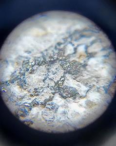
Micro-photograph of RC drill chip with sulfide in hydrothermal quartz from drill hole AMRC22_001 at 705 feet depth. Field of view is 1cm. First-pass drilling by VR in 2022 is targeting the main IP anomalies at Amsel for pyrite and hydrothermal quartz in altered rhyolite tuffisite breccia because there is an association of gold and silver mineralization with pyrite alteration on surface at Amsel, and along the entire 20 km trend of mineral showings in the Big Ten caldera.
Figure 2.
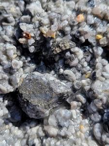
Photograph of RC drill chips from drill hole AMRC22_002 at 370 feet, including pyrite in hydrothermal quartz and individual grains of sulfide. First-pass drilling by VR in 2022 is targeting the main IP anomalies at Amsel for pyrite and hydrothermal quartz in altered rhyolite tuffisite breccia because there is an association of gold and silver mineralization with pyrite alteration on surface at Amsel, and along the entire 20 km trend of mineral showings in the Big Ten caldera.
Figure 3.
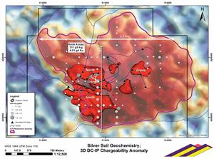
Location of the three RC holes completed in March, 2022, relative to the DCIP anomalies shown in in red, themselves located in the southwest quadrant of the large airborne radiometric potassium anomaly which is coincident with quartz-adularia alteration map on surface and covering the hilltop at Amsel. The north-south profile line locates the cross-section shown in Figure 4. Black triangles are permitted drill holes. First-pass drilling is in two stages: RC drill holes completed this winter test the northern IP anomaly, and the south IP anomaly, and Grove, will be drill tested this summer.
Figure 4.
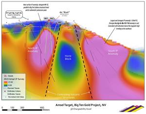
A north-south section through the 3D inversion block model derived from the DIAS 3D-array DCIP survey completed in 2019. Shown schematically are the three RC drill holes completed in the northern IP anomaly. The second leg of drilling planned for this summer will focus on the larger, southern IP anomaly. For reference, the chargeability anomalies in pink are shown in red on the plan map in Figure 3.
2022 GlobeNewswire, Inc., source
