VANCOUVER, British Columbia, June 11, 2019 (GLOBE NEWSWIRE) -- VR Resources Ltd. (TSX.V: VRR, FSE: 5VR; OTCBB: VRRCF), the "Company", or “VR”, is pleased to announce that exploration is underway at its recently staked Ranoke copper-gold property in northern Ontario. This work will refine drill targets already apparent from the compilation of regional government surveys and archived mineral exploration assessment reports.
Figure 1. High resolution airborne gravity and magnetic survey.
A graphic accompanying this announcement is available at https://www.globenewswire.com/NewsRoom/AttachmentNg/303cec8d-9e4b-422f-89bf-6962434f90ea
The Company has executed a service agreement with Sander Geophysics Ltd. for an airborne geophysical survey which is now underway at Ranoke. Final data and reports are anticipated within 4-8 weeks. The fixed wing survey will produce high resolution gravity and magnetic data over a block approximately 13 x 14 kilometres in size, with a 200 metre line-spacing, and orthogonal tie lines flown on a one kilometre spacing for improved data modeling. The fixed-wing gravity system includes three separate cesium vapour magnetometer sensors to provide integrated horizontal gradient magnetic data.
The gravity signature of iron oxide copper gold deposits (IOCG) in Australia is well-established because of the high density of iron oxide and copper sulfide minerals in massive breccia form. The high sensitivity, low frequency AIRGrav system of Sander chosen for the Ranoke survey will achieve a sensitivity of 0.1mGal, and provide two key exploration vectors to evaluate, refine, and prioritize specific IOCG targets within the Ranoke magnetic complex for first-pass drill testing being considered for this fall:
- Given the number of magnetic anomalies at Ranoke, the survey will prioritize which anomalies are the highest density and therefore the most prospective for an iron-copper breccia body;
- Given the size of the individual magnetic anomalies, the survey will map density variations within any given anomaly and prioritize high density zones more prospective for iron-copper breccia.
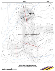
Figure 2. High Resolution soil gas geochemical transects.
A graphic accompanying this announcement is available at https://www.globenewswire.com/NewsRoom/AttachmentNg/6079a039-c6a0-490d-91b8-ab7ff9ecb190
The Company has executed a service agreement with C.O. Geosciences Inc. for a high-resolution soil gas geochemical survey utilizing proprietary, AGI sorbent-based passive samplers. Some 156 stations are planned on five separate transects four to five kilometres long across the five largest magnetic anomalies to test for large, degassing sulfide bodies at depth. The initial field component of sampler deployment is underway. Final data and reports are anticipated in August.
The AGI samplers will collect and measure volatile and semi-volatile compounds present in air, soil, gas and water. The technology has been refined and proven by use in more than 40 countries during the past decade. Importantly, the survey design at Ranoke calls for sampler deployment four to six feet below surface, in the upper-most layers of till and soil and below water-saturated surface muskeg.
The soil gas technology being used is not hindered by the moisture content of bog terrain, nor are resultant anomalies impeded by thick till above a buried sulfide target. The technology is proven for gold and base metal exploration in similar terrain farther to the south in the Abitibi Belt in central Ontario.
From VR’s CEO Dr. Michael H. Gunning “VR is committed to the innovative application of new exploration technologies towards previously untested targets within proven, established mineral belts. Both the airborne gravity and soil gas geochemical surveys at Ranoke have been three months in survey design and planning, from the selection of technologies available, to the design of survey parameters specific to the Ranoke target. Our goal is the discovery of a copper-gold deposit at one or more of the large magnetic pipes at Ranoke, and we believe the gravity and soil gas technologies at Sander and AGI respectively will optimize our chance of success. These surveys epitomize the low cost but high impact value of blue-sky exploration; VR will advance the Ranoke IOCG targets with both discipline and conviction, and we look forward to providing further updates as our work advances.”
About the Ranoke Property
The Ranoke property is located in northern Ontario, Canada. Infrastructure local to Ranoke is shown on location figures provided at the Company’s website at www.vrr.ca. The property is 15 kilometers west of the CNR railway spur which supplies Moosonee located on tide water 100 kilometres to the northeast, and it is 50 kilometres north of road access to Coral Rapids, an Ontario hydroelectric facility serviced by Highway 634. Exploration at Ranoke is facilitated by the town of Cochrane which is located about 100 kilometres to the south on the Trans Canada Highway, and is the major service hub to the region.
The Ranoke property is large. It consists of 345 claims in one contiguous block covering 7,072 ha in an area 12 x 12 kilometres in size. The Ranoke property was staked directly by VR. It is owned 100% by VR, free and clear of any interests or royalties.
Technical Information
Summary technical and geological information on the Company’s various exploration properties is available at the Company’s website at www.vrr.ca.
Technical information for this news release has been prepared in accordance with the Canadian regulatory requirements set out in National Instrument 43-101. Justin Daley, P.Geo., Principal Geologist at VR and a non-independent Qualified Person oversees and/or participates in all aspects of the Company’s mineral exploration projects. The content of this news release has been reviewed on behalf of the Company by the CEO, Dr. Michael Gunning, P.Geo., a non-independent Qualified Person.
Corporate Update
For greater clarity, the Closing Date of the non-brokered financing previously announced on May 10, 2019, has been extended to June 24, 2019.
About VR Resources
VR is an emerging junior exploration company focused on greenfields opportunities in copper and gold (TSX.V: VRR; Frankfurt: 5VR; OTCBB: VRRCF). The diverse experience and proven track record of its Board in early-stage exploration, discovery and M&A is the foundation of VR. The Company is focused on exploring large copper-gold mineral systems in the western United States and Canada. VR is the continuance of 4 years of active exploration in Nevada by a Vancouver-based private exploration company. VR is well financed for its exploration strategy. VR owns its properties outright, and evaluates new opportunities on an ongoing basis, whether by staking or acquisition.
ON BEHALF OF THE BOARD OF DIRECTORS:
“Michael H. Gunning”
_____________________________
Dr. Michael H. Gunning, PhD, PGeo
President & CEO
For general information please use the following:
Website: www.vrr.ca
Email: info@vrr.ca
Phone: 604-262-1104
Forward Looking Statements
This press release contains forward-looking statements. Forward-looking statements are typically identified by words such as: believe, expect, anticipate, intend, estimate, and similar expressions or are those which, by their nature, refer to future events. Forward looking statements in this release include but are not limited to: “ … drill targets already apparent from the compilation of regional government surveys; … final data and reports are anticipated in August.”
Although the Company believes that the use of such statements are reasonable, there can be no assurance that such statements will prove to be accurate, and actual results and future events could differ materially from those anticipated in such statements. The Company cautions investors that any forward-looking statements by the Company are not guarantees of future performance, and that actual results may differ materially from those in forward-looking statements. Trading in the securities of the Company should be considered highly speculative. All of the Company’s public disclosure filings are available at www.sedar.com; readers are urged to review these materials.
Neither the TSX Venture Exchange nor its Regulation Services Provider (as that term is defined in Policies of the TSX Venture Exchange) accepts responsibility for the adequacy or accuracy of this release.
![]()
Figure 1.
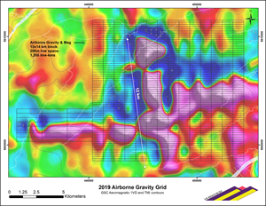
Airborne gravity and magnetic survey grid for the Ranoke property in northern Ontario. Survey grid lines and orthogonal tie lines are shown on a regional magnetic base map from the Geological Survey of Canada, flown at 800 metre line-spacing.
Figure 2.