(via TheNewswire)
 | |||||||||
The program is planned around 2 – 4 drill holes, for between 1,500 and 2,000 metres in total, projected to take approximately one month to complete, with assays expected through May and June.
Water supply, heavy equipment services, and camp are all located just six kilometres from the drill, with access off state highway I95.
Strategy
The drill program is the result of two years of field-based mapping and sampling by VR, and the utilization of four, state-of-the-art geophysical surveys completed in succession, and utilizing technologies not available during the main period of exploration at New Boston from the mid–1960s through the late 1970s. For example, this drill program will focus on the new,
Historic drill holes located to both the east and the south of the west-plunging
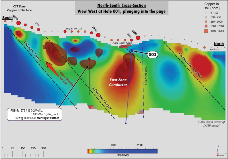
Look at the cross-section in Figure 3. The large volume DCIP conductor at
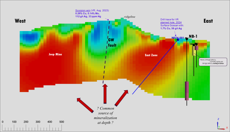
The long-section in Figure 4 demonstrates the potential for hole NB24-001 shown in Figure 1:
The drill hole is literally starting in quartz vein rubble with copper sulfide and copper oxide at surface, grading up to 1.7% copper in hand samples, and;
Our planned drill holes at
East Zone stay within the structural, stratigraphic and 3D conductivity models for copper mineralization for their entirety.
From VR’s CEO, Dr.
We look forward to providing further updates as our drilling progresses. In concert with the strengthening price in copper as the Green Economy emerges, New Boston’s time has arrived.
Field Videos
A short video from several previous site visits are available on the New Boston Project Page on the Company’s website at www.vrr.ca. Also, on the Home Page itself, is a 20 minute video overview of the New Boston project and drill targets, illustrated in PowerPoint.
Technical Information
Summary technical and geological information for the Company’s various exploration properties including New Boston is available at the Company’s website atwww.vrr.ca.
Technical information for this news release has been prepared in accordance with the Canadian regulatory requirements set out in National Instrument 43-101.
About the New Boston Property
Location
New Boston is within the
New Boston is located in the
The property location facilitates cost-effective exploration, year-round. Access is from the nearby town of
Property Description
The New Boston property is large: it consists of 77 claims in one contiguous block approximately 3 x 5km in size and covering 583 hectares in total (1,441 acres). It covers the entire extent of the known copper-moly-silver porphyry-skarn mineral system exposed on surface between
The property is on federal land administered by the
The property is owned 100% by VR. There are no underlying annual lease payments; nor are there any joint venture or back-in interests. The vendor of the property retains a royalty.
About
VR is an established junior exploration company based in
ON BEHALF OF THE BOARD OFDIRECTORS:
“Michael H. Gunning”
____________________________
Dr.
President & CEO
For general information please use the following:
Website: www.vrr.ca
Email: info@vrr.ca
Phone: 778-731-9292
Forward Looking Statements
This news release contains statements that constitute "forward-looking statements". Such forward looking statements involve known and unknown risks, uncertainties and other factors that may cause the Company’s actual results, performance or achievements, or developments in the industry to differ materially from the anticipated results, performance or achievements expressed or implied by such forward-looking statements. Forward-looking statements are statements that are not historical facts and are generally, but not always, identified by the words "expects," "plans," "anticipates," "believes," "intends," "estimates," "projects," "potential" and similar expressions, or that events or conditions "will," "would," "may," "could" or "should" occur. Forward-looking statements in this document include statements concerningVR’splans to drill its New Bostonproperty, the current price strength of copper, and all other statements that are not statements of historical fact.
Although the Company believes the forward-looking information contained in this news release is reasonable based on information available on the date hereof, by their nature forward-looking statements involve assumptions, known and unknown risks, uncertainties and other factors which may cause our actual results, performance or achievements, or other future events, to be materially different from any future results, performance or achievements expressed or implied by such forward-looking statements.
Examples of such assumptions, risks and uncertainties include, without limitation, assumptions, risks and uncertainties associated with general economic conditions; the Covid-19 pandemic; adverse industry events; future legislative and regulatory developments in the mining sector; the Company’s ability to access sufficient capital from internal and external sources, and/or inability to access sufficient capital on favorable terms; mining industry and markets in
The forward-looking information contained in this news release represents the expectations of the Company as of the date of this news release and, accordingly, is subject to change after such date. Readers should not place undue importance on forward-looking information and should not rely upon this information as of any other date. While the company may elect to, it does not undertake to update this information at any particular time except as required in accordance with applicable laws.
This news release may also contain statements and/or information with respect to mineral properties and/or deposits which are adjacent to and/or potentially similar to the Company’s mineral properties, but which the Company has no interest in nor rights to explore. Readers are cautioned that mineral deposits on similar properties are not necessarily indicative of mineral deposits on the Company’s properties.
Trading in the securities of the Company should be considered highly speculative. All of the Company’s public disclosure filings may be accessed viawww.sedarplus.caand readers are urged to review them.
Neither the
-----
Click Image To View Full Size
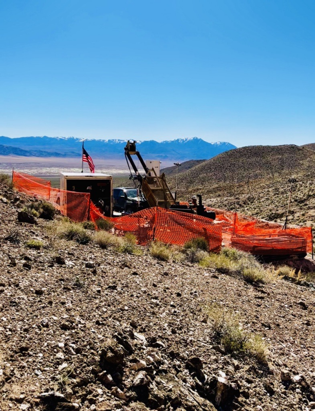
Figure 1. Photo of the drill on
Click Image To View Full Size
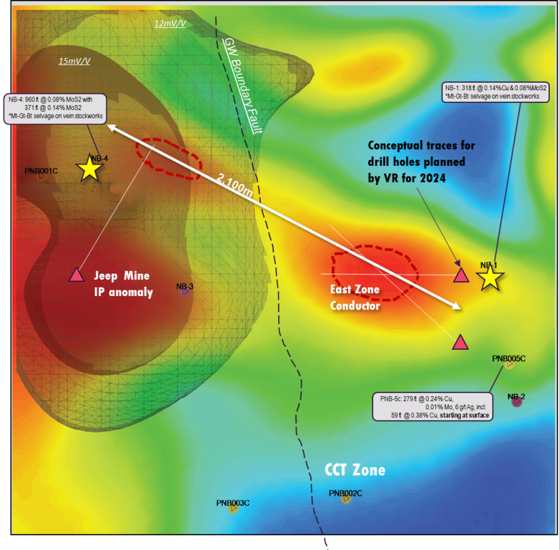
Figure 2. DCIP plan map with IP isoshells overlain on a conductivity depth slice base map. The IP anomaly at
Click Image To View Full Size
Figure 3. North-south cross-section through the 3D conductivity model shown on plan map in Figure 2. Note soil with up to 0.8% Cu above
Click Image To View Full Size
Figure 4. View north at east-west long section through the 3D conductivity model shown on plan map in Figure 2. Copper-silver veins on surface along the central GW fault and gossan trace (see Figure 2) emanate vertically upwards from a potential source porphyry stock where the
Copyright (c) 2024 TheNewswire - All rights reserved.
Copyright (c) 2024 TheNewswire - All rights reserved., source
